Credit: Credit: NASA Worldview, Earth Observing System Data and Information System (EOSDIS)
Satellite data has confirmed that Humberto, once a major hurricane is now a post-tropical cyclone. NASA’s Terra Satellite provided a visible image of Post-Tropical Cyclone Humberto as it continued moving in an easterly direction through the North Atlantic Ocean.
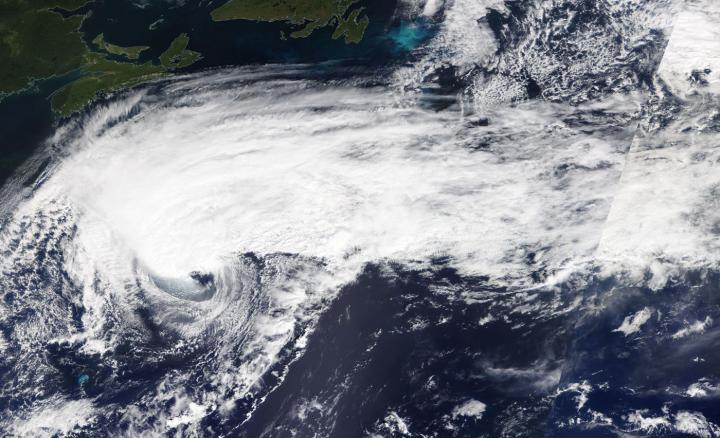
At 11 a.m. EDT on Sept. 19, Humberto was still a powerful hurricane, but the system was in the process of transitioning to an extratropical cyclone. NASA satellite images indicated that frontal features had formed as indicated by its elongated appearance. Cooler and drier air was also wrapping around the western and southern sides of the circulation.
On Sept. 19 at 1:30 p.m. EDT, the Moderate Imaging Spectroradiometer or MODIS instrument that flies aboard NASA’s Terra satellite provided a visible image of Humberto and it was almost a post-tropical cyclone. The image and other satellite images showed a well-defined cold and warm front, but they did not appear to be fully connected to the center of circulation. The MODIS image indicated Humberto was still producing an area of strong thunderstorms northwest of the exposed low-level center.
By 11 p.m. EDT, satellite images showed little strong thunderstorm development, and it was well to the north of the center of the cyclone. Imagery also showed cold air stratocumulus clouds over the western and southern portions. Those cold clouds are indicative of cold air advection (cold air moving in) that is characteristic of an extratropical cyclone. As a result, Humberto was designated post-tropical and the final advisory on the system was issued by the National Hurricane Center.
A Post-Tropical Storm is a generic term for a former tropical cyclone that no longer possesses sufficient tropical characteristics to be considered a tropical cyclone. Former tropical cyclones that have become fully extratropical, subtropical, or remnant lows, are three classes of post-tropical cyclones. In any case, they no longer possesses sufficient tropical characteristics to be considered a tropical cyclone. However, post-tropical cyclones can continue carrying heavy rains and high winds.
At 11 p.m. EDT on Sept. 19 (0300 UTC on Sept. 20), the center of Hurricane Humberto was located near latitude 40.0 degrees north and longitude 58.0 degrees west making the center about 525 nautical miles south-southwest of Cape Race, Newfoundland, Canada. Humberto is moving toward the north-northeast and had maximum sustained winds near 85 knots (98 mph/157 kph).
Humberto is expected to be a large and powerful extratropical cyclone for a couple of days before it is absorbed by another extratropical low-pressure area over the North Atlantic Ocean.
NOAA’s National Hurricane Center noted that large swells would continue to affect Bermuda, the northwestern Bahamas, and the east coast of the United States from east-central Florida to the Mid-Atlantic states during the next couple of days. These swells could create life-threatening surf and rip current conditions.
Hurricanes are the most powerful weather event on Earth. NASA’s expertise in space and scientific exploration contributes to essential services provided to the American people by other federal agencies, such as hurricane weather forecasting.
###
For updated forecasts, visit: http://www.
By Rob Gutro
NASA’s Goddard Space Flight C
Media Contact
Rob Gutro
[email protected]
Original Source
https:/


