Credit: NASA JPL, Sang-Ho Yun and Jungkyo Jung
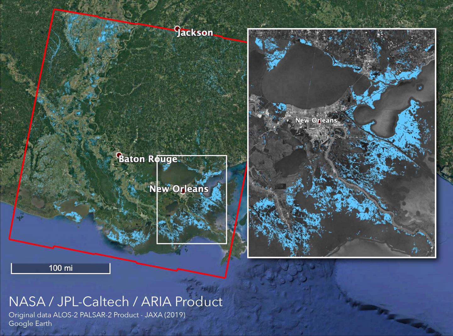
Even before Tropical Storm Barry made landfall in Louisiana on Saturday, July 13, it had already dropped a lot of rain on the state. Using satellite data, NASA created a map that shows areas that are likely flooded.
The Advanced Rapid Imaging and Analysis (ARIA) team at NASA’s Jet Propulsion Laboratory (JPL) in Pasadena, Calif., created an ARIA Flood Proxy Map (FPM) on July 13, depicting areas of Louisiana that are likely flooded as a result of heavy rain and Tropical storm Barry,” said Judy Lai, project manager for ARIA at NASA’s JPL. Those areas appear in light blue pixels on the map.
The maps were created from synthetic aperture radar (SAR) data acquired on July 13, 2019 by the ALOS-2 satellite operated by the Japan Aerospace Exploration Agency (JAXA). The map covers an area of 220 by 236 miles (355 by 380 kilometers). Each pixel measures about 27 yards (25 meters) across. This flood proxy map can be used as guidance to identify areas that are likely flooded, and may be less reliable over urban and vegetated areas.
On July 15, the National Weather Service of New Orleans noted, “Heavy rain bands associated with Tropical Depression Barry will continue to impact the area today and tonight. Additional rainfall amounts of 1 to 3 inches will be possible in these heavy rain bands, especially north of the Interstate 10 and 12 corridors. Potential impacts include flash flooding due to excessive rainfall and rises on area rivers. If you live in a flood-prone area, take action to protect your property ahead of time. As always, have multiple ways to receive warnings and know where you will go if you need to move to higher ground.”
At 11:14 a.m. EDT on July 15, there were many Flash Flood Warnings still in effect. They include:
- Southeastern Rapides Parish in central Louisiana…
Northern Jefferson Davis Parish in southwestern Louisiana…
Beauregard Parish in southwestern Louisiana…
Evangeline Parish in central Louisiana…
Northwestern Acadia Parish in southwestern Louisiana…
Central Calcasieu Parish in southwestern Louisiana…
Avoyelles Parish in central Louisiana…
Northern St. Landry Parish in central Louisiana…
Allen Parish in southwestern Louisiana…
At 1:30 p.m. EDT on July 15, the flood warning continues for the Intracoastal Waterway at Bayou Sorrel Lock affecting Iberville Parish, Louisiana.
The original data to created that map was provided by JAXA. It was then analyzed by the NASA-JPL/Caltech ARIA team and carried out at JPL, funded by NASA Disasters Program.
At 11 a.m. EDT on July 15, Barry was located about 70 miles (115 km) west-northwest of Little Rock, Arkansas. Barry continues to track to the north near 12 mph (19 kph) and this motion is expected to become northeasterly on Tuesday and easterly on Wednesday.
###
For more information about ARIA, visit: http://aria.
By Rob Gutro
NASA’s Goddard Space Flight Center
Media Contact
Rob Gutro
[email protected]
Original Source
https:/


