• HOME
  • NEWS
  • EXPLORE
    • CAREER
      • Companies
      • Jobs
    • EVENTS
    • iGEM
      • News
      • Team
    • PHOTOS
    • VIDEO
    • WIKI
  • BLOG
  • COMMUNITY
    • FACEBOOK
    • INSTAGRAM
    • TWITTER
Monday, July 28, 2025
BIOENGINEER.ORG
No Result
View All Result
  • Login
  • HOME
  • NEWS
  • EXPLORE
    • CAREER
      • Companies
      • Jobs
        • Lecturer
        • PhD Studentship
        • Postdoc
        • Research Assistant
    • EVENTS
    • iGEM
      • News
      • Team
    • PHOTOS
    • VIDEO
    • WIKI
  • BLOG
  • COMMUNITY
    • FACEBOOK
    • INSTAGRAM
    • TWITTER
No Result
View All Result
Bioengineer.org
No Result
View All Result
Home NEWS Science News

NASA catches Tropical Storm Tapah by the tail

Bioengineer by Bioengineer
September 20, 2019
in Science News
Reading Time: 2 mins read
0
ADVERTISEMENT
Share on FacebookShare on TwitterShare on LinkedinShare on RedditShare on Telegram

IMAGE

Credit: Credit: NASA Worldview

Tropical Storm Tapah has a huge “tail” on NASA satellite imagery. NASA’s Terra satellite captured an image of the northwestern Pacific Ocean storm that revealed a large band of thunderstorms that resemble a large tail. The NASA imagery also indicated that the storm is getting better organized.

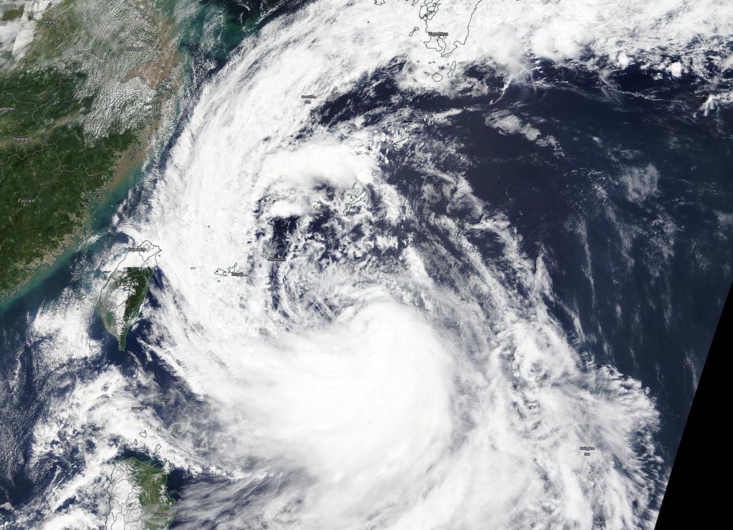
On Sept. 19, the Moderate Imaging Spectroradiometer or MODIS instrument that flies aboard NASA’s Terra satellite provided a visible image of Tapah. The image showed the center of the storm was a good distance east of Taiwan and the northern Philippines. From the storm’s center a large band of thunderstorms extended from its western side, and stretched through the East China Sea all the way north into the Sea of Japan. That large thunderstorm band made up Tapah’s “tail.”

The image also showed that there is a large band of powerful thunderstorms circling Tapah’s low-level center of circulation. The shape of the storm is a clue to forecasters that a storm is either strengthening or weakening. If a storm takes on a more rounded shape it is getting more organized and strengthening. Conversely, if it becomes less rounded or elongated, it is a sign the storm is weakening. Tapah has appeared to become more symmetrical in the MODIS imagery, indicating it is getting better organized.
At 11 a.m. EDT (1500 UTC) on Sept. 20, the center of Tropical Storm Tapah was located near latitude 24.6 degrees north and longitude 127.1 degrees east. That puts the center about 147 nautical miles south of Kadena Air Force Base, Okinawa, Japan. Maximum sustained winds were near 50 knots (57 mph/92 kph).

The Joint Typhoon Warning Center or JTWC noted that Tapah was moving to the north-northeast. JTWC uses satellite imagery in their forecasts and has indicated that Tapah is strengthening. The JTWC forecast takes Tapah on a curved path to the northwest then northeast and through the Sea of Japan over Sept. 22 and 23.

Hurricanes are the most powerful weather event on Earth. NASA’s expertise in space and scientific exploration contributes to essential services provided to the American people by other federal agencies, such as hurricane weather forecasting.

For updated forecasts, visit: https://www.nhc.noaa.gov

###

Media Contact
Rob Gutro
[email protected]

Original Source

https://blogs.nasa.gov/hurricanes/2019/09/20/tapah-northwestern-pacific-ocean-2/

Tags: Atmospheric ChemistryAtmospheric ScienceClimate ChangeClimate ScienceEarth ScienceMeteorologyTechnology/Engineering/Computer ScienceTemperature-Dependent PhenomenaWeather/Storms
Share14Tweet9Share2ShareShareShare2

Related Posts

blank

Advanced Pressure-Velocity Patch Enhances Flight Detection

July 27, 2025
blank

Durable, Flexible Electrochemical Transistors via Electropolymerized PEDOT

July 26, 2025

Challenges and Opportunities in High-Filled Polymer Manufacturing

July 26, 2025

Epicardial Fat: Protector or Threat to Heart Health?

July 26, 2025
Please login to join discussion

POPULAR NEWS

  • Blind to the Burn

    Overlooked Dangers: Debunking Common Myths About Skin Cancer Risk in the U.S.

    52 shares
    Share 21 Tweet 13
  • USF Research Unveils AI Technology for Detecting Early PTSD Indicators in Youth Through Facial Analysis

    42 shares
    Share 17 Tweet 11
  • Dr. Miriam Merad Honored with French Knighthood for Groundbreaking Contributions to Science and Medicine

    45 shares
    Share 18 Tweet 11
  • Engineered Cellular Communication Enhances CAR-T Therapy Effectiveness Against Glioblastoma

    35 shares
    Share 14 Tweet 9

About

We bring you the latest biotechnology news from best research centers and universities around the world. Check our website.

Follow us

Recent News

Advanced Pressure-Velocity Patch Enhances Flight Detection

Durable, Flexible Electrochemical Transistors via Electropolymerized PEDOT

Challenges and Opportunities in High-Filled Polymer Manufacturing

  • Contact Us

Bioengineer.org © Copyright 2023 All Rights Reserved.

Welcome Back!

Login to your account below

Forgotten Password?

Retrieve your password

Please enter your username or email address to reset your password.

Log In
No Result
View All Result
  • Homepages
    • Home Page 1
    • Home Page 2
  • News
  • National
  • Business
  • Health
  • Lifestyle
  • Science

Bioengineer.org © Copyright 2023 All Rights Reserved.