Credit: NASA JPL/Heidar Thrastarson
Tropical Cyclone Pola was passing near the Southern Pacific country of Fiji when NASA’s Aqua satellite analyzed the storm in infrared light and found it strengthening.
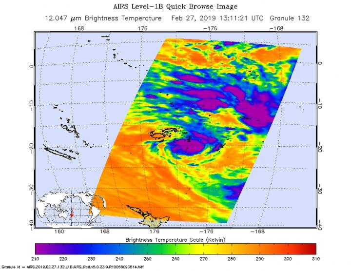
On Feb. 27 at 8:11 p.m. EDT (1311 UTC) the Atmospheric Infrared Sounder or AIRS instrument aboard NASA’s Aqua satellite analyzed cloud top temperatures of Tropical Cyclone Pola in infrared light. AIRS found cloud top temperatures were getting colder. Colder cloud tops mean the uplift of air in the storm is strengthening and pushing the cloud tops higher. It’s an indication of a strengthening storm.
Strongest thunderstorms as cold as or colder than minus 63 degrees Fahrenheit (minus 53 degrees Celsius) circling the center. Enhanced infrared satellite imagery shows deep and persistent convection continues to wrap around the low level circulation center. Cloud top temperatures that cold indicate strong storms that have the capability to create heavy rain. Microwave imagery revealed a partial eye developing.
On Feb. 21 at 10 a.m. EST (1500 UTC), the center of Tropical Cyclone Pola was located near latitude 21.0 degrees south and longitude 178.0 degrees west. That puts the center of Pola between Fiji and Tonga and about 258 nautical miles southeast of Suva, Fiji. Pola was moving to the south-southwest. Maximum sustained winds were near 75 knots (86 mph/139 kph). The Joint Typhoon Warning Center expects Pola to strengthen in the next day before slow weakening begins.
###
By Rob Gutro
NASA’s Goddard Space Flight Center
Media Contact
Rob Gutro
[email protected]
Original Source
https:/


