Credit: NASA JPL/Heidar Thrastarson
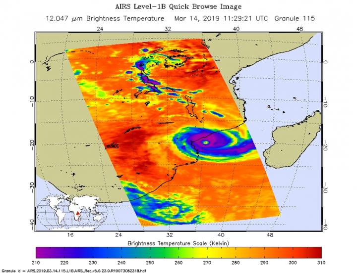
Tropical Cyclone Idai was approaching landfall in Mozambique when NASA’s Aqua satellite provided an infrared look at the cloud top temperatures to determine the strongest parts of the storm.
On March 14, warnings were in effect in Mozambique as Idai nears landfall. Idai will affect (parts of) the Mozambique provinces of Zambézia, Sofala, Manica and Inhambane with very strong winds (190 to 210 kilometers per hour), accompanied by very heavy rains (more than 150 mm in 24 hours) and severe thunderstorms. INAM also foresees the continuation of moderate to strong rains (30 to 50 mm / 24h), accompanied by severe thunderstorms and gusty winds north of the provinces of Niassa and Cabo Delgado.
On March 14 at 7:29 a.m. EDT (1129 UTC) the Atmospheric Infrared Sounder or AIRS instrument aboard NASA’s Aqua satellite analyzed cloud top temperatures of Tropical Cyclone Idai in infrared light. AIRS found cloud top temperatures were as cold as or colder than minus 63 degrees Fahrenheit (minus 53 degrees Celsius) circling the eye. Cloud top temperatures that cold indicate strong storms that have the capability to create heavy rain.
On March 14 at 11 a.m. EDT (1500 UTC), the center of Tropical Cyclone Idai was located near latitude 19.9 degrees south and longitude 36.3 degrees east. That puts the center of Idai about 258 nautical miles west-northwest of Europa Island. Idai’s western quadrant was already pummeling Mozambique. Maximum sustained winds were near 100 knots (115 mph/185 kph). The Joint Typhoon Warning Center expects that Idai will maintain current intensity until landfall occurs near Beira, Mozambique within 24 hours.
###
For the latest advisory from the Mozambique National Meteorology Institute (INAM), visit: http://www.
By Rob Gutro
NASA’s Goddard Space Flight Center
Media Contact
Rob Gutro
[email protected]
Original Source
https:/


