Credit: Courtesy: NASA Worldview, Earth Observing System Data and Information System (EOSDIS).
Tropical Depression 15 strengthened into a tropical storm late on Sept. 1 and was renamed Omar. Visible imagery from NASA-NOAA’s Suomi NPP satellite was compiled into an animation that showed the system’s formation and strengthening. NASA’s Terra satellite also provided temperature data on Omar that revealed wind shear was affecting the storm.
Another Record-Breaker
Omar is the 15th named storm of the 2020 Atlantic hurricane season, and is the earliest 15th storm on record, besting the previous mark by about a week from Ophelia of 2005.
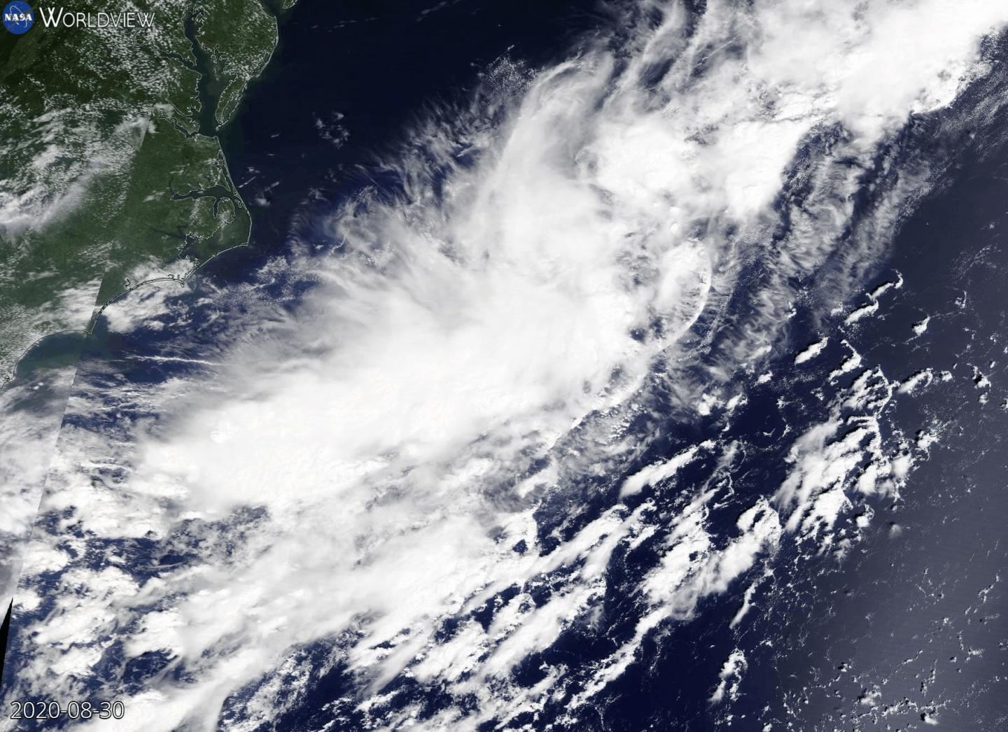
NASA Animates Omar’s Development
At NASA’s Goddard Space Flight Center in Greenbelt, Md. using the NASA Worldview platform an animation of satellite imagery was created to show Omar over three days. Using visible imagery from the Visible Infrared Imaging Radiometer Suite (VIIRS) instrument aboard NASA-NOAA’s Suomi NPP satellite, an animation shows the development, organization and movement of Tropical Depression 15 from Aug. 30 to Sept. 1 off the coast of North Carolina. On Sept. 2, it became Tropical Storm Omar.
This animation of visible imagery from the VIIRS instrument aboard NASA-NOAA’s Suomi NPP satellite shows the organization and movement of Tropical Depression 15 from Aug. 30 to Sept. 1 off the coast of North Carolina. On Sept. 2, it became Tropical Storm Omar. Courtesy: NASA Worldview, Earth Observing System Data and Information System (EOSDIS).
Infrared Data Reveals Wind Shear Battering Omar
Strong upper-level winds are battering Omar and pushing the strongest storms to the southeastern quadrant. Those northwesterly winds are not expected to let up, putting Omar on a weakening trend. NASA’s infrared data showed how those outside winds were displacing the strongest storms in Omar’s circulation.
On Sept. 1 at 10 p.m. EDT (Sept. 2 at 0200 UTC), the Moderate Resolution Imaging Spectroradiometer or MODIS instrument aboard NASA’s Terra satellite gathered temperature information about Tropical Storm Omar’s cloud tops. MODIS found the most powerful thunderstorms were on the southeastern side of the storm, where temperatures were as cold as or colder than minus 70 degrees Fahrenheit (minus 56.6 Celsius). Cloud top temperatures that cold indicate strong storms with the potential to generate heavy rainfall.
“Satellite images show that the system remains sheared with a bursting pattern on satellite, occasionally exposing the center, and a large area of curved bands in the southeastern quadrant of the circulation,” Eric Blake wrote in the 5 a.m. EDT Omar Discussion. Blake is a senior hurricane specialist at NOAA’s National Hurricane Center (NHC) in Miami, Florida.
Omar’s Status on Sept. 2
At 5 a.m. EDT (0900 UTC), NOAA’s NHC noted the center of Tropical Storm Omar was located near latitude 36.2 degrees north and longitude 68.7 degrees west. Omar was centered about 350 miles (560 km) northwest of Bermuda. The storm is moving toward the east-northeast near 14 mph (22 kph), and this general motion is expected to continue through this afternoon. Maximum sustained winds are near 40 mph (65 km/h) with higher gusts. Little change in strength is expected through tonight. The estimated minimum central pressure is 1003 millibars.
Omar’s Bleak Forecast
The NHC forecast calls for Omar to turn toward the east during the evening hours on Sept. 2, with a reduction in forward speed occurring through Friday, Sept. 4. Weakening should begin by Thursday, Sept. 3, with Omar likely to become a remnant low-pressure area by Thursday night.
###
About NASA’s Worldview
NASA’s Earth Observing System Data and Information System (EOSDIS) Worldview application provides the capability to interactively browse over 700 global, full-resolution satellite imagery layers and then download the underlying data. Many of the available imagery layers are updated within three hours of observation, essentially showing the entire Earth as it looks “right now.”
Tropical cyclones/hurricanes are the most powerful weather events on Earth. NASA’s expertise in space and scientific exploration contributes to essential services provided to the American people by other federal agencies, such as hurricane weather forecasting.
For updated forecasts, visit: http://www.
By Rob Gutro
NASA’s Goddard Space Flight Center
Media Contact
Rob Gutro
[email protected]
Original Source
https:/


