Credit: NASA/NRL
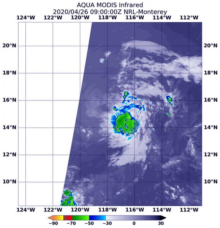
The Eastern Pacific Ocean’s hurricane season may not officially start until mid-May, but the first tropical cyclone of the season formed over the weekend of April 25 and 26. NASA’s Aqua satellite provided an infrared look at the small depression when it was at its peak and before it became post-tropical.
Tropical Depression 1E formed on Saturday, April 25 and by the next day, it was not in a favorable environment for further development, according to the National Hurricane Center (NHC). NASA’s Aqua satellite provided forecasters with a look at 1E’s cloud top temperatures to assess the strength of the storm.
NASA’s Aqua satellite passed over Tropical Depression 1E on Sunday, April 26, 2020 at 5 a.m. EDT (0900 UTC) and the Moderate Resolution Imaging Spectroradiometer or MODIS instrument aboard analyzed 1E in infrared light. Infrared light is used to determine temperature of cloud tops in storms, and the colder the cloud top, the higher it is in the troposphere (lowest layer of the atmosphere), and the stronger the storm tends to be. MODIS found cloud top temperatures as cold as minus 50 degrees Fahrenheit in the depression, not cold enough to suggest heavy rainfall.
On April 26, the National Hurricane Center (NHC) reported, “Deep convection has been waning quickly in the southeastern quadrant since the previous advisory, and the system barely met criteria for identifying it as a tropical cyclone at 1200 UTC (8 a.m. EDT).”
NHC said at 11 a.m. EDT (8 a.m. PDT) the center of Tropical Depression 1E was located near latitude 15.7 north, longitude 118.8 west. At that time, 1E reached its peak with maximum sustained winds near 35 mph (55 kph). The system weakened throughout the day and overnight as it encountered, “Deep-layer dry air and cooler sea-surface temperatures, combined with strong westerly shear of 25 to 30 knots,” NHC noted.
On Monday, April 27, 2020, the NHC said that post-tropical remnant low 1E was far from land areas as it continued to degenerate. It was centered near latitude 17 degrees north and longitude 121 degrees west. The estimated minimum central pressure was 1010 millibars. Maximum sustained winds were 25 knots (29 mph/46 kph).
A post-tropical storm is a generic term for a former tropical cyclone that no longer possesses sufficient tropical characteristics to be considered a tropical cyclone. Former tropical cyclones can become fully extratropical, subtropical, or remnant lows, which are three classes of post-tropical cyclones. In any case, they no longer possesses sufficient tropical characteristics to be considered a tropical cyclone. However, post-tropical cyclones can continue carrying heavy rains and high winds.
This system was only retaining shallow convection. It continued to weaken as it moved toward the west-northwest. NHC expects the system to dissipate by Tuesday, April 28.
Hurricane season officially begins on May 15 in the Eastern Pacific Ocean, so this depression was early for season. For more information about NHC, visit: http://www.
Typhoons/ hurricanes are the most powerful weather events on Earth. NASA’s expertise in space and scientific exploration contributes to essential services provided to the American people by other federal agencies, such as hurricane weather forecasting.
The MODIS instrument is one of six instruments flying on board NASA’s Aqua satellite which launched on May 4, 2002.
###
Media Contact
Rob Gutro
[email protected]
Original Source
https:/


