Credit: Credit: NASA JPL/Heidar Thrastarson
NASA’s Aqua satellite analyzed a low-pressure area in the far eastern Atlantic Ocean, and it showed the system becoming more organized. Soon after Aqua passed overhead, the low became Tropical Depression 21. Hours later, the storm strengthened into Tropical Storm Vicky.
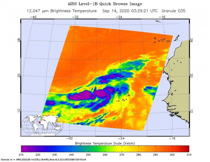
Infrared Imagery Revealed a Consolidating System
One of the ways NASA researches tropical cyclones is using infrared data that provides temperature information. The AIRS instrument aboard NASA’s Aqua satellite captured a look at those temperatures in the developing low-pressure area and gave insight into the size of the storm and its rainfall potential.
Cloud top temperatures provide information to forecasters about where the strongest storms are located within a tropical cyclone. Tropical cyclones do not always have uniform strength, and some sides are stronger than others. The stronger the storms, the higher they extend into the troposphere, and the colder the cloud temperatures. NASA provides that data to forecasters at NOAA’s National Hurricane Center or NHC so they can incorporate in their forecasting.
On Sept. 14 at 0329 UTC (Sept. 13 at 11:29 a.m. EDT) NASA’s Aqua satellite analyzed the low-pressure area using the Atmospheric Infrared Sounder or AIRS instrument. AIRS found coldest cloud top temperatures as cold as or colder than minus 63 degrees Fahrenheit (minus 53 degrees Celsius) around the center of circulation. NASA research has shown that cloud top temperatures that cold indicate strong storms that have the capability to create heavy rain.
Forecasters looked at wind speeds in the storm to determine that it had strengthened into a tropical storm. The Advanced Scatterometer (ASCAT) winds products are processed by NOAA/NESDIS utilizing measurements from the scatterometer instrument aboard the European Organisation for the Exploitation of Meteorological Satellites (EUMETSAT) Metop satellites.
U.S. Navy Hurricane Specialist Dave Roberts at NOAA’s National Hurricane Center in Miami, Fla. noted, “A METOP A/B ASCAT scatterometer pass over the cyclone showed a large swath of winds in the northeast quadrant on the order of 35 to 39 knots. Deep convection in that region of the cyclone continues to increase as well as near the center of circulation. Accordingly, the initial intensity is raised to 40 knots, making this the twentieth named storm of the season.”
Vicky’s Status of Sept. 14
At 11 a.m. EDT (1500 UTC), Vicky was centered about 350 miles (565 km) west-northwest of the Cabo Verde Islands. The center was near latitude 18.7 degrees north and longitude 28.5 degrees west. Vicky was moving toward the northwest near 6 mph (9 kph) and this motion is forecast to continue into this afternoon. A turn toward the northwest is forecast tonight, with a west-northwestward motion expected on Tuesday and Wednesday.
Maximum sustained winds have increased to near 45 mph (75 kph) with higher gusts. Little change in strength is expected during the next day or so. The estimated minimum central pressure is 1002 millibars.
Vicky’s Forecast
NHC expects Vicky will be a short-lived tropical cyclone as increasing southwesterly wind shear (winds from the outside of the tropical cyclone that batter and weaken them) is expected to quickly weaken Vicky to a depression in a couple days, and the system is expected to degenerate to a remnant low pressure area on Thursday, Sept. 17.
The AIRS instrument is one of six instruments flying on board NASA’s Aqua satellite, launched on May 4, 2002.
NASA Researches Tropical Cyclones
Hurricanes/tropical cyclones are the most powerful weather events on Earth. NASA’s expertise in space and scientific exploration contributes to essential services provided to the American people by other federal agencies, such as hurricane weather forecasting.
For more than five decades, NASA has used the vantage point of space to understand and explore our home planet, improve lives and safeguard our future. NASA brings together technology, science, and unique global Earth observations to provide societal benefits and strengthen our nation. Advancing knowledge of our home planet contributes directly to America’s leadership in space and scientific exploration.
###
For updated forecasts, visit: http://www.
By Rob Gutro
NASA’s Goddard Space Flight Center
Media Contact
Rob Gutro
[email protected]
Original Source
https:/


