Credit: Credit: NASA/NRL
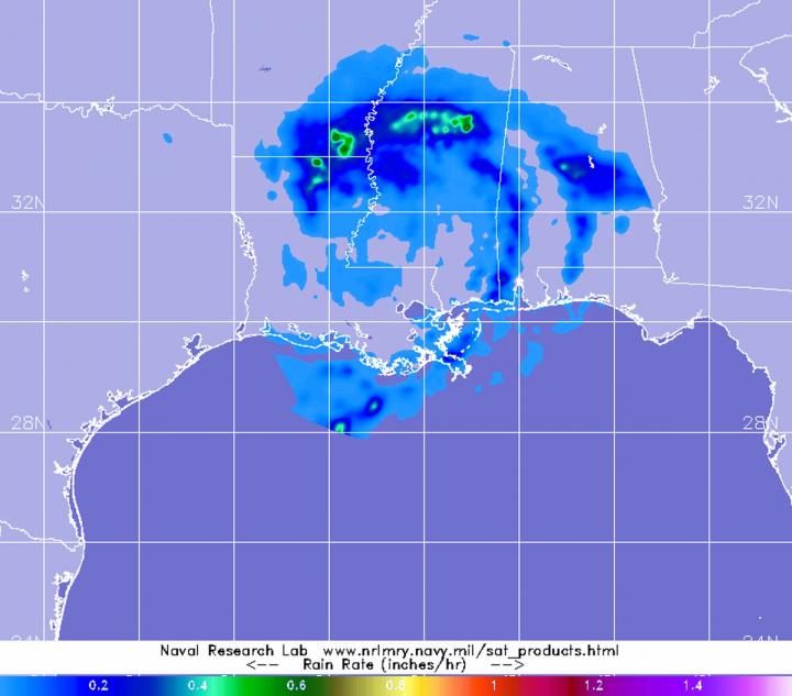
When Tropical Storm Cristobal made landfall in southern Louisiana yesterday, May 7, it dropped a lot of rain, and continues to as it weakens and moves inland. NASA’s GPM satellite provided a look at the rainfall rates in the now depression.
The Global Precipitation Measurement mission or GPM core satellite passed over Cristobal on June 8 at 7:46 a.m. EDT (1146 UTC). GPM found heaviest rainfall north of center falling at rates of 1 inch (25 mm) per hour over northern Louisiana, southern Arkansas and northern Mississippi. Light rain appears around the entire system, falling at less than 0.2 inches (less than 5 millimeters) per hour.
Large Rainfall Totals Expected
The heavy rainfall rates that GPM observed are expected to add up to large amounts of rain on the ground, and the National Hurricane Center provided an estimate in the latest forecast on June 8, 2020.
NHC said, “Cristobal is expected to produce storm total rainfall accumulations of 5 to 10 inches across portions of the central to eastern Gulf Coast into the Lower Mississippi Valley, with isolated amounts to 15 inches. Rainfall totals of 2 to 4 inches with local amounts to 6 inches are expected across portions of the mid-to-Upper Mississippi Valley and Northern Plains near and in advance of Cristobal. This rainfall has led to flash flooding and forecast widespread river flooding across portions of the central Gulf Coast into the Lower Mississippi Valley. Smaller streams across southeast Louisiana and southern Mississippi have begun to rise and are forecast to crest mid-week. New and renewed significant river flooding is possible across the mid and upper Mississippi Valley.”
Gusty winds and isolated tornadoes are possible today with the depression. Gusty winds could also occur Tuesday night and Wednesday over portions of the Midwest and western Great Lakes as Cristobal becomes an extratropical low. Isolated tornadoes are possible today and tonight across Mississippi, Alabama, southeastern Louisiana, eastern Arkansas, western Tennessee, and southeastern Missouri. Ocean swells generated by Cristobal are still affecting portions of the northern and eastern Gulf coast and are likely causing life-threatening surf and rip current conditions.
Cristobal’s Status on Monday, June 8, 2020
At 8 a.m. EDT (1200 UTC), the center of Tropical Depression Cristobal was located near latitude 31.8 degrees north and longitude 91.6 degrees west. That puts the center of circulation about 50 miles (75 km) south-southeast of Monroe, Louisiana. The depression is moving toward the north-northwest near 10 mph (17 km/h) and this motion should continue today. Maximum sustained winds were 35 mph (55 kph) with higher gusts. The estimated minimum central pressure based on surface observations is 994 millibars.
Cristobal’s Forecast Path
NHC forecasters expect that Cristobal will weaken through Tuesday. However, Cristobal is expected to strengthen some as it becomes an extratropical low pressure area Tuesday [June 9] night and Wednesday [June 10].
NHC expects a turn toward the north tonight, followed by a faster north-northeast motion Tuesday and Wednesday. On the forecast track, the center of Cristobal should move through northeastern Louisiana today, through Arkansas and eastern Missouri tonight and Tuesday, and reach Wisconsin and the western Great Lakes by Wednesday.
Tropical cyclones/hurricanes are the most powerful weather events on Earth. NASA’s expertise in space and scientific exploration contributes to essential services provided to the American people by other federal agencies, such as hurricane weather forecasting.
GPM is a joint mission between NASA and the Japan Aerospace Exploration Agency, JAXA. The Suomi NPP satellite is a joint mission with NASA and NOAA.
For updated forecasts, visit: http://www.
###
Media Contact
Rob Gutro
[email protected]
Original Source
https:/


