Credit: Credits: NASA/NRL
NASA’s Aqua satellite analyzed the cloud top temperatures and water vapor content in Hurricane Sally as it crawls toward landfall, and found the potential for large amounts of rainfall, which, coupled with slow movement, can lead to catastrophic flooding. Two instruments provided three views of Sally’s temperatures and water vapor that revealed the soaking capability of the slow-moving hurricane.
At 8 a.m. EDT on Sept. 15, NOAA’s National Hurricane Center (NHC) cautioned, “Historic flooding is possible from Sally with extreme life-threatening flash flooding likely through Wednesday [Sept. 16] along portions of the northern Gulf Coast.” Forecasters are using NASA’s infrared and water vapor data to analyze the rainfall potential from Sally.
Warnings and Watches in Effect on Sept. 15
NHC issued a Storm Surge Warning for the mouth of the Mississippi River to the Okaloosa/Walton County Line, Florida and for Mobile Bay. A Hurricane Warning is in effect for east of the Mouth of the Pearl River to Navarre, Florida. A Tropical Storm Warning is in effect for east of Navarre, Florida to Indian Pass, Florida and from the mouth of the Pearl River westward to Grand Isle, Louisiana, including Lake Pontchartrain and Lake Maurepas and metropolitan New Orleans.
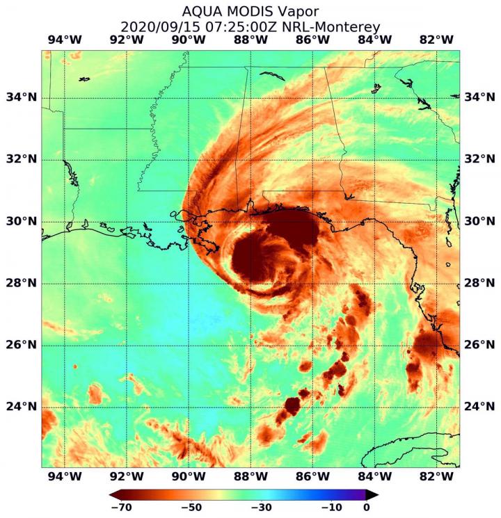
NASA’s Infrared Data Reveals Heavy Rainmakers
Tropical cyclones consist of hundreds of thunderstorms, and infrared data can show where the strongest storms are located. That is because infrared data provides temperature information, and the strongest thunderstorms that reach highest into the atmosphere have the coldest cloud top temperatures. Two instruments aboard NASA’s Aqua satellite provided infrared data on Sally’s cloud tops.
On Sept. 15 at 3:25 a.m. EDT (0725 UTC), the Moderate Resolution Imaging Spectroradiometer or MODIS instrument that flies aboard NASA’s Aqua satellite revealed the most powerful thunderstorms were around Hurricane Sally’s center and in the northeastern quadrant. In those areas, cloud top temperatures were as cold as or colder than minus 80 degrees Fahrenheit (minus 62.2 Celsius). They were located over the Gulf of Mexico and just offshore from coastal Alabama, Mississippi and the Florida Panhandle. Strong storms with cloud top temperatures as cold as minus 70 degrees Fahrenheit (minus 56.6. degrees Celsius) surrounded both areas and were generating large amounts of rain.
Four minutes later, another instrument aboard NASA’s Aqua satellite analyzed Sally’s cloud top temperatures to verify the data from MODIS. The Atmospheric Infrared Sounder or AIRS instrument or AIRS instrument showed the strongest storms were offshore in the northern Gulf of Mexico where they were as cold as or colder than 210 Kelvin (minus 81 degrees Fahrenheit (minus 63.1 degrees Celsius). NASA research has shown that cloud top temperatures that cold indicate strong storms that have the capability to create heavy rain.
Water Vapor Content
Water vapor analysis of tropical cyclones tells forecasters how much potential a storm has to develop. Water vapor releases latent heat as it condenses into liquid. That liquid becomes clouds and thunderstorms that make up a tropical cyclone. Temperature is important when trying to understand how strong storms can be. The higher the cloud tops, the colder and stronger the storms.
On Sept. 15 at 3:25 a.m. EDT (0725 UTC) Aqua’s MODIS instrument also gathered water vapor content and temperature information on Sally. The MODIS image showed the highest concentrations of water vapor and coldest cloud top temperatures were around the center of circulation and in the northeastern quadrant of the storm. The water vapor data showed the coldest cloud top temperatures were as cold as or colder than minus 70 degrees Fahrenheit (minus 56.6 degrees Celsius) in those storms. Storms with cloud top temperatures that cold have the capability to produce heavy rainfall.
Sally’s Rainfall Forecast from NHC
The NHC warns, “Sally is expected to be a slow moving system as it approaches land producing 10 to 20 inches of rainfall with isolated amounts of 30 inches along and just inland of the central Gulf Coast from the western Florida Panhandle to far southeastern Mississippi. Historic flooding is possible with extreme life-threatening flash flooding likely through Wednesday. In addition, this rainfall will lead to widespread moderate to major flooding on area rivers.
Sally is forecast to move inland early Wednesday and move across the Southeast producing rainfall of 4 to 8 inches, with isolated maximum amounts of 12 inches, across portions of southeastern Mississippi, southern and central Alabama, northern Georgia, and the western Carolinas. Significant flash and urban flooding is likely, as well as widespread minor to moderate flooding on some rivers.”
Sally’s Status on Sept. 15
At 8 a.m. EDT (1200 UTC) on Sept. 15, the National Hurricane Center noted the center of Hurricane Sally was located near latitude 29.1 degrees north and longitude 88.0 degrees west. That is about 65 miles (110 km) east of the mouth of the Mississippi River.
Sally is moving toward the northwest near 2 mph (4 kph), and this general motion is expected to continue this morning. A northward turn is expected this afternoon, followed by a slow north-northeastward to northeastward motion tonight and continuing through Wednesday night. Maximum sustained winds are near 85 mph (140 kph) with higher gusts. The estimated minimum central pressure based on data from the Air Force Hurricane Hunter aircraft is 982 millibars.
Sally’s Forecast Track
NHC said, “Although little change in strength is forecast until landfall occurs, Sally is still expected to be a dangerous hurricane when it moves onshore along the north-central Gulf coast. On the forecast track, the center of Sally will pass near the coast of southeastern Louisiana today, and make landfall in the hurricane warning area tonight or Wednesday morning.”
NASA Researches Tropical Cyclones
Hurricanes are the most powerful weather event on Earth. NASA’s expertise in space and scientific exploration contributes to essential services provided to the American people by other federal agencies, such as hurricane weather forecasting.
NASA’s Aqua satellite is one in a fleet of NASA satellites that provide data for hurricane research.
For more than five decades, NASA has used the vantage point of space to understand and explore our home planet, improve lives and safeguard our future. NASA brings together technology, science, and unique global Earth observations to provide societal benefits and strengthen our nation. Advancing knowledge of our home planet contributes directly to America’s leadership in space and scientific exploration.
By Rob Gutro
NASA’s Goddard Space Flight Center
###
Media Contact
Rob Gutro
[email protected]
Original Source
https:/


