Credit: Credits: NASA/NRL
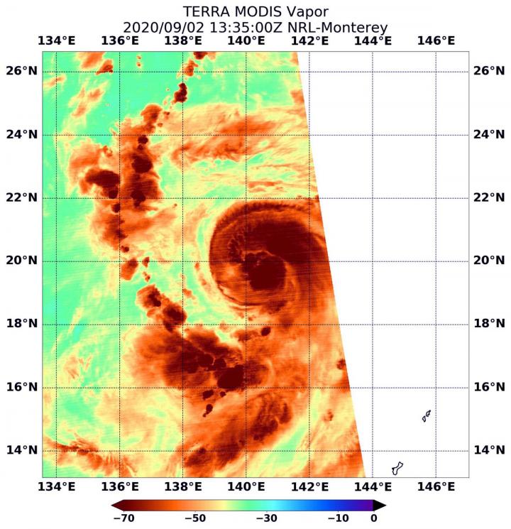
When NASA’s Terra satellite passed over the Northwestern Pacific Ocean, it gathered water vapor data on recently developed Typhoon Haishen and found powerful storms in two locations.
Haishen strengthened quickly. It developed on August 31 as Tropical Depression 11W, and by Sept. 1, it had reached tropical storm status. By Sept. 2, it was a typhoon.
Water vapor analysis of tropical cyclones tells forecasters how much potential a storm has to develop. Water vapor releases latent heat as it condenses into liquid. That liquid becomes clouds and thunderstorms that make up a tropical cyclone. Temperature is important when trying to understand how strong storms can be. The higher the cloud tops, the colder and the stronger the storms.
NASA’s Terra satellite passed over Haishen on Sept. 2 at 9:35 a.m. EDT (1335 UTC), and the Moderate Resolution Imaging Spectroradiometer or MODIS instrument gathered water vapor content and temperature information. The MODIS image showed highest concentrations of water vapor and coldest cloud top temperatures were around the center of circulation and in a large band of thunderstorms in the northeastern quadrant of the storm.
MODIS data also showed coldest cloud top temperatures were as cold as or colder than minus 70 degrees Fahrenheit (minus 56.6 degrees Celsius) in those storms. Storms with cloud top temperatures that cold have the capability to produce heavy rainfall.
On Sept. 2 at 11 a.m. EDT (1500 UTC), Typhoon Haishen had maximum sustained winds near 70 knots (80 mph/130 kph) and it was strengthening. It was centered near latitude 19.5 degrees north and longitude 140.4 degrees east, about 812 nautical miles east-southeast of Kadena Air Base, Okinawa, Japan. Haishen was moving to the west-northwest.
Haishen’s Forecast Path Expected Similar to Maysak’s
As Typhoon Maysak approaches landfall in southern South Korea today, forecasters at the Joint Typhoon Warning Center now expect Haishen to follow a similar path.
Haishen will veer to the northwest while intensifying to 120 knots. The storm is forecast to move west of Kyushu, Japan, and will make landfall in South Korea after four days.
NASA’s Terra satellite is one in a fleet of NASA satellites that provide data for hurricane research.
NASA Researches Tropical Cyclones
Hurricanes/tropical cyclones are the most powerful weather events on Earth. NASA’s expertise in space and scientific exploration contributes to essential services provided to the American people by other federal agencies, such as hurricane weather forecasting.
For more than five decades, NASA has used the vantage point of space to understand and explore our home planet, improve lives and safeguard our future. NASA brings together technology, science, and unique global Earth observations to provide societal benefits and strengthen our nation. Advancing knowledge of our home planet contributes directly to America’s leadership in space and scientific exploration.
###
By Rob Gutro
NASA’s Goddard Space Flight Center
Media Contact
Rob Gutro
[email protected]
Original Source
https:/


