Credit: Credit: NASA/NOAA/NRL
Using a NASA satellite rainfall product that incorporates data from satellites and observations, NASA estimated Hurricane Teddy’s rainfall rates as it approaches Bermuda on Sept. 21. Teddy is a large hurricane and growing. It is also churning up seas all the way to the U.S. and Canadian coastlines.
Watches and Warnings on Sept. 21
NOAA’s National Hurricane Center posted a Tropical Storm Warning for Bermuda and a Tropical Storm Watch is in effect from Lower East Pubnico to Main-a-Dieu, Nova Scotia, Canada.
Teddy’s Status on Sept. 21
At 11 a.m. EDT (1500 UTC), the center of Hurricane Teddy was located near latitude 31.1 degrees north and longitude 62.7 degrees west. That is about 150 miles (240 km) east-southeast of Bermuda and about 935 miles (1,500 km) south of Halifax, Nova Scotia, Canada.
Teddy was moving toward the north-northeast near 14 mph (22 kph), and this motion is expected to continue today, followed by a turn toward the north overnight and north-northwest on Tuesday. Maximum sustained winds were near 90 mph (150 kph) with higher gusts. Teddy is a large hurricane. Hurricane-force winds extend outward up to 80 miles (130 km) from the center and tropical-storm-force winds extend outward up to 230 miles (370 km).
An Air Force Reserve Hurricane Hunter aircraft recently reported a minimum central pressure of 960 millibars.
Estimating Teddy’s Rainfall Rates from Space
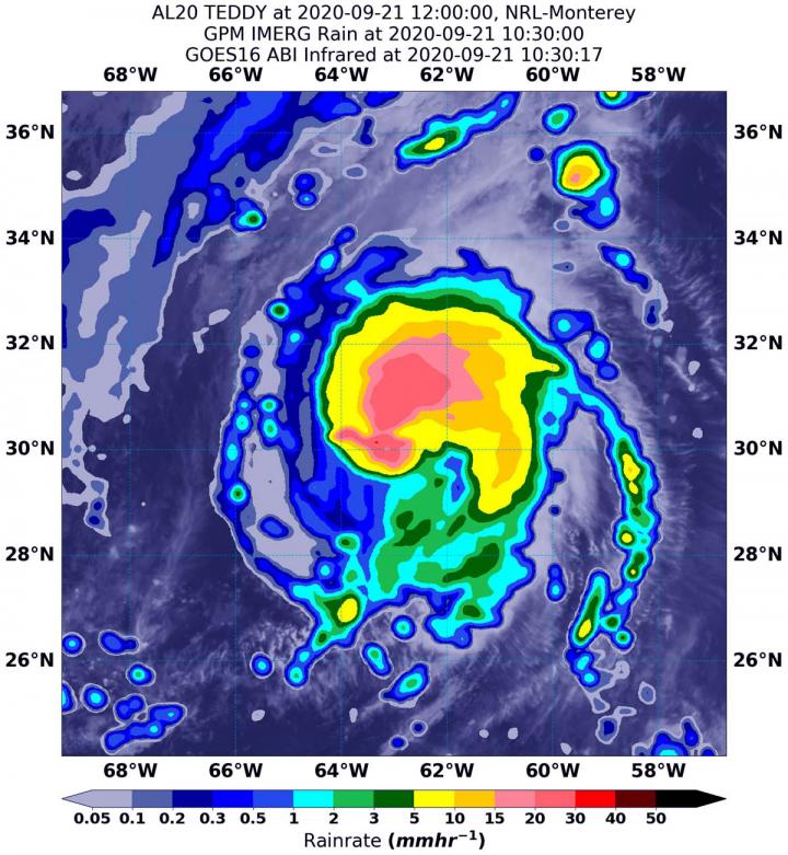
NASA’s Integrated Multi-satellitE Retrievals for GPM or IMERG, which is a NASA satellite rainfall product, estimated on Sept. 21 at 6:30 a.m. EDT (1030 UTC), Teddy was generating as much as 30 mm (1.18 inches) of rain per hour around the center of circulation.
Rainfall throughout most of the storm was estimated as falling at a rate between 5 and 15 mm (0.2 to 0.6 inches) per hour. At the U.S. Naval Laboratory in Washington, D.C., the IMERG rainfall data was overlaid on infrared imagery from NOAA’s GOES-16 satellite to provide a full extent of the storm.
As Teddy moves north, that heavy rainfall is expected across Atlantic Canada between Tuesday and Thursday.
What Does IMERG Do?
This near-real time rainfall estimate comes from the NASA’s IMERG, which combines observations from a fleet of satellites, in near-real time, to provide near-global estimates of precipitation every 30 minutes. By combining NASA precipitation estimates with other data sources, we can gain a greater understanding of major storms that affect our planet.
What the IMERG does is “morph” high-quality satellite observations along the direction of the steering winds to deliver information about rain at times and places where such satellite overflights did not occur. Information morphing is particularly important over the majority of the world’s surface that lacks ground-radar coverage. Basically, IMERG fills in the blanks between weather observation stations
NHC Key Messages
The National Hurricane Center issued three key messages as Hurricane Teddy approaches Bermuda and grows in size:
The center of Teddy is forecast to move east of Bermuda today. Wind gusts of tropical-storm-force have been reported on the island, and tropical storm conditions could continue today.
`Teddy is expected to transition to a powerful post-tropical cyclone as it moves near or over portions of Atlantic Canada late Tuesday through Thursday, where there is an increasing risk of direct impacts from wind, rain, and storm surge. A Tropical Storm Watch is in effect for portions of Nova Scotia, and heavy rainfall across Atlantic Canada is expected with Teddy between Tuesday and Thursday after it becomes a strong post-tropical cyclone.
`Large swells produced by Teddy are expected to affect portions of Bermuda, the Leeward Islands, the Greater Antilles, the Bahamas, the east coast of the United States, and Atlantic Canada during the next few days. These swells will likely cause life-threatening surf and rip current conditions.
Teddy’s Forecast
“Teddy’s size will likely increase substantially during the next couple of days as it moves northward and interacts with a frontal system,” said Eric Blake, a senior hurricane specialist at NOAA’s National Hurricane Center in Miami, Florida. “Gale force winds are likely along portions of the near shore waters of the northeast U.S.”
NHC forecasters said Teddy should turn to the north-northeast as it approaches Nova Scotia on Wednesday. Teddy is expected to gain strength overnight, but weaken steadily by Wednesday and become a strong post-tropical cyclone.
NASA Researches Tropical Cyclones
Hurricanes/tropical cyclones are the most powerful weather events on Earth. NASA’s expertise in space and scientific exploration contributes to essential services provided to the American people by other federal agencies, such as hurricane weather forecasting.
For more than five decades, NASA has used the vantage point of space to understand and explore our home planet, improve lives and safeguard our future. NASA brings together technology, science, and unique global Earth observations to provide societal benefits and strengthen our nation. Advancing knowledge of our home planet contributes directly to America’s leadership in space and scientific exploration.
###
For more information about NASA’s IMERG, visit: https:/
For forecast updates on hurricanes, visit: http://www.
By Rob Gutro
NASA’s Goddard Space Flight Center
Media Contact
Rob Gutro
[email protected]
Original Source
https:/


