Credit: NASA/JAXA/NRL
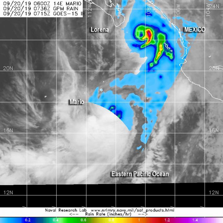
Two tropical cyclones are very close together near the coast of western Mexico. Hurricane Lorena was moving over the southern tip of Baja California, and Tropical Storm Mario was south of Lorena over the Eastern Pacific Ocean. NASA calculated the rainfall rates happening in both of those tropical cyclones.
NASA has the unique capability of peering under the clouds in storms and measuring the rate in which rain is falling. The Global Precipitation Measurement mission or GPM core satellite passed over the region from its orbit in space and measured rainfall rates in these storms.
GPM passed over the Eastern Pacific Ocean on Sept. 20 at 3:36 a.m. EDT (0736 UTC) and provided rainfall rates in Hurricane Lorena and Tropical Storm Mario, close in proximity. The heaviest rainfall was occurring in the eastern side of Lorena, falling at a rate of over 36 mm (about 1.4 inch) per hour and at a rate of 25 mm (about 1 inch) per hour around the center and band of thunderstorms east of center.
Forecasters at NOAA’s National Hurricane Center or NHC incorporate the rainfall data into their forecasts. NHC said that Lorena is expected to produce rainfall accumulations of 3 to 6 inches, with maximum amounts around 8 inches, across the far southern Baja California Sur. This rainfall may result in flash flooding.
GPM also showed rain rates of 25 mm (about 1 inch) per hour around the center of Mario. Microwave imagery has indicated that Mario has been able to maintain its low-level structure, but deep convection was mostly southwest of the cyclone’s surface center, although that was outside of the GPM overpass. Both the Japan Aerospace Exploration Agency, JAXA and NASA manage GPM.
Hurricane Lorena Affecting Baja California, Mexico
A Hurricane Warning is in effect for Baja California peninsula from La Paz to Puerto Cortes, a Hurricane Watch is in effect for the East coast of the Baja California peninsula north of La Paz to San Evaristo. A Tropical Storm Warning is in effect for Puerto Cortes to Cabo San Lazaro, a Tropical Storm Watch is in effect for the east coast of the Baja California peninsula north of San Evaristo to Loreto and for the west coast of the Baja California peninsula north of Cabo San Lazaro to Puerto San Andresito.
Compact Hurricane Lorena on Sept. 20, 2019
NASA satellite data has also shown that Lorena is a compact hurricane. Hurricane-force winds extend outward up to 10 miles (20 km) from the center and tropical-storm-force winds extend outward up to 60 miles (95 km).
At 11 a.m. EDT (1500 UTC), the center of Hurricane Lorena was located near latitude 22.7 North, longitude 109.0 West. Lorena is moving toward the west at near 2 mph (4 kph), and a turn toward the west-northwest with some increase in forward speed is expected on Saturday, Sept. 20. Maximum sustained winds are near 75 mph (120 kph) with higher gusts. Some additional strengthening is possible today, but weakening is likely to begin by Saturday night, and then either degenerate into a remnant low, or become absorbed by Tropical Storm Mario in a couple of days. The estimated minimum central pressure is 987 millibars.
On the forecast track, the center of Lorena will pass near or over the southern portion of the Baja California peninsula later today, and then gradually move away from the west coast of the peninsula tonight and Saturday.
Tropical Storm Mario on Sept. 20, 2019
At 11 a.m. EDT (1500 UTC), the center of Tropical Storm Mario was located near latitude 17.9 degrees north and longitude 110.1 degrees west. That is about 345 miles (555 km) south of the southern tip of Baja California, Mexico.
Mario is moving toward the north-northeast at near 5 mph (7 kph). A sharp turn toward the north and then toward the northwest is expected later today. A turn toward the west-northwest is forecast on Saturday; however, confidence in the forecast is low. Maximum sustained winds are near 65 mph (100 kph) with higher gusts. Some strengthening is possible today, with weakening expected to begin on Saturday and continue through Sunday night.
The estimated minimum central pressure is 994 millibars. Interests in the southern Baja California peninsula should monitor the progress of Mario.
Hurricanes are the most powerful weather event on Earth. NASA’s expertise in space and scientific exploration contributes to essential services provided to the American people by other federal agencies, such as hurricane weather forecasting.
For updated forecasts, visit: http://www.
###
Media Contact
Rob Gutro
[email protected]
Original Source
https:/


