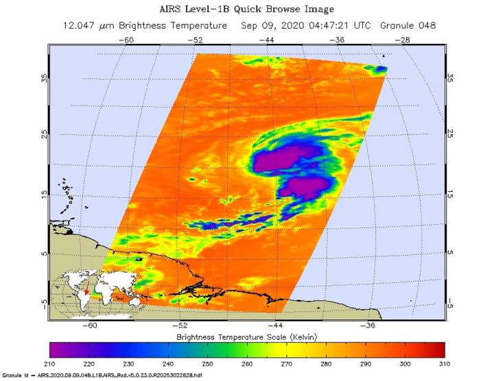
Credit: NASA JPL/Heidar Thrastarson
NASA’s Aqua satellite analyzed Tropical Storm Paulette in infrared imagery as it moved through the Central Atlantic Ocean. At NASA, the imagery was false-colored to show cloud-top temperature gradients and identify the locations of the strongest storms. The imagery also indicated Paulette was being affected by wind shear.
Infrared Imagery and Paulette’s Strength
One of the ways NASA researches tropical cyclones is using infrared data that provides temperature information. The AIRS instrument aboard NASA’s Aqua satellite captured a look at those temperatures in Paulette and gave insight into the size of the storm and its rainfall potential.
Cloud top temperatures provide information to forecasters about where the strongest storms are located within a tropical cyclone. Tropical cyclones do not always have uniform strength, and some sides have stronger sides than others. The stronger the storms, the higher they extend into the troposphere, and the colder the cloud top temperatures. NASA provides that data to forecasters at NOAA’s National Hurricane Center or NHC so they can incorporate in their forecasting.
On Sept. 9 at 12:47 a.m. EDT (0447 UTC) NASA’s Aqua satellite analyzed Tropical Storm Paulette using the Atmospheric Infrared Sounder or AIRS instrument. AIRS found coldest cloud top temperatures as cold as or colder than minus 63 degrees Fahrenheit (minus 53 degrees Celsius) northeast of the center and in a band of thunderstorms south of center. The center is near the southern side of a large thunderstorm cluster, with the bulk of deep convection in the northeastern quadrant of the cyclone.
NASA research has shown that cloud top temperatures that cold indicate strong storms that have the capability to create heavy rain.
Paulette had maximum sustained winds near 60 mph (95 kph) at the time of the AIRS image. Wind shear continued to affect the storm and weakened it over the next day.
What is Wind Shear?
In general, wind shear is a measure of how the speed and direction of winds change with altitude. Tropical cyclones are like rotating cylinders of winds. Each level needs to be stacked on top each other vertically in order for the storm to maintain strength or intensify. Wind shear occurs when winds at different levels of the atmosphere push against the rotating cylinder of winds, weakening the rotation by pushing it apart at different levels. Wind shear from the west-southwest was pushing the bulk of strong thunderstorms northeast of Paulette’s center.
Paulette’s Status of Sept. 10
By 5 a.m. EDT (0900 UTC) on Sept. 10, although Paulette’s center of circulation had separated farther south from the cloud mass during the early morning hours, infrared imagery showed the cyclone was still producing an area of deep convection and strong thunderstorms consisting of minus 79 degrees Celsius (minus 110.2 degrees Fahrenheit) cold cloud tops.
Robbie Berg, hurricane specialist at NOAA’s National Hurricane Center in Miami, Florida, noted at 11 a.m. EDT on Sept. 10, “Southwesterly shear has increased over the cyclone as expected, with the latest University of Wisconsin-Madison-CIMSS analysis now between 35 and 40 knots.” The wind shear is expected to peak by 11 p.m. EDT on Sept. 10, so a little more weakening is anticipated over the next day or so. The shear is then forecast to gradually abate.
At 11 a.m. EDT (1500 UTC), NHC reported the center of Tropical Storm Paulette was located near latitude 21.5 degrees north and longitude 49.1 degrees west. That is about 935 miles (1,510 km) east-northeast of the Northern Leeward Islands. Paulette is moving toward the west-northwest near 10 mph (17 kph). A west-northwestward or northwestward motion with some increase in forward speed is expected through the weekend. Maximum sustained winds have decreased to near 50 mph (85 kph) with higher gusts.
Paulette’s Forecast
NHC expects a west-northwestward or northwestward motion with some increase in forward speed through the weekend. Some additional slight weakening is expected during the next day or so, but Paulette is then forecast to re-strengthen by Saturday. Paulette could become a hurricane by Sunday or Monday.
There are no coastal watches or warnings in effect. Interests in Bermuda should monitor the progress of this system. Ocean swells forecast to spread across the southwestern Atlantic through the weekend.
###
The AIRS instrument is one of six instruments flying on board NASA’s Aqua satellite, launched on May 4, 2002.
For more than five decades, NASA has used the vantage point of space to understand and explore our home planet, improve lives and safeguard our future. NASA brings together technology, science, and unique global Earth observations to provide societal benefits and strengthen our nation. Advancing knowledge of our home planet contributes directly to America’s leadership in space and scientific exploration.
For updated forecasts, visit: http://www.
By Rob Gutro
NASA’s Goddard Space Flight Center
Media Contact
Rob Gutro
[email protected]
Original Source
https:/


