
Credit: Visual by Garrett Dash Nelson and Alasdair Rae.
Geographers from Dartmouth College and the University of Sheffield provide new insight into the economic geography of commuter megaregions in the U.S., by using an empirical approach that combines visual interpretation with statistical analysis. The findings appear in "PLOS One" and shed light on an old geographic problem: how to divide space into coherent unit areas.
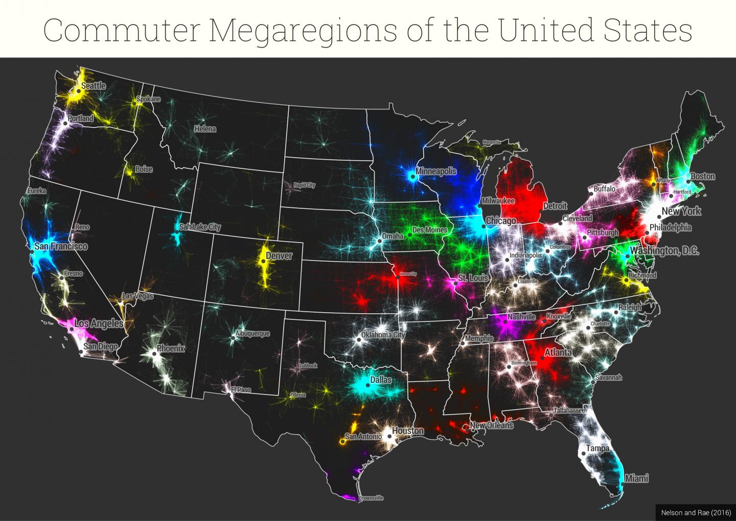
These emerging "megaregions" reflect the economic links woven by millions of commuters traveling to and from work each day. They map out complex networks in which economic systems, natural resources and infrastructure are linked. Understanding the way functional geographic connections cross over the existing borderlines of states and regions is vital for developing institutional forms that match the patterns of the contemporary world.
"We know just how interconnected people are across vast distances in the modern economy–that's one of the basic principles of globalization," says co-author Garrett Dash Nelson, a postdoctoral fellow in the department of Geography and the Society of Fellows at Dartmouth College. "But we still need bounded areal units for things like regional administration and transportation planning. Our paper offers a new way of thinking about how these economic flows and megaregional boundaries are related."
The study examines 4 million commuter flows based on Census Tract data from the Census Bureau's American Community Survey (ACS) 2006-2010. The Census Tract was selected as the spatial unit of measure given that with an average population of 4,000, this unit was geographically large enough to reflect a major number of employers.
The geographers applied two methodologies: a visual heuristic approach and an algorithmic approach, and explain the shortcomings of relying on one approach. For the visual heuristic approach, which is based on a trial and error method to produce results, the ACS data was filtered based on distance and flow volume thresholds until visually effective results were obtained. For this approach, 50 miles was used as the threshold to measure "long distance commutes." The visual approach enables an interpretive depiction of centers of employment and suburban flows; however, with no hard edges within the visual, it is difficult to determine where a functional commuter region or community may exist. This approach therefore requires subjective guesswork to determine regional edges.
The algorithmic approach tries to assign the census tracts or nodes into communities based on the number of commuters, using the Combo software developed at MIT's Senseable City Lab. The algorithm relies on the connectivity between nodes and does not take into consideration geographic proximity. This method can identify spatially contiguous areas that one would not ordinarily be able to determine visually. The algorithm is able to make judgement calls that one cannot make with a map.
Below are visuals from the study reflecting commutes to Minneapolis-St.Paul within a 50-mile radius based on the visual heuristic approach as compared to commutes within the Twin Cities region using the algorithmic approach. The map of the Twin Cities region illustrates the spatial connectivity or in this case, the functional commuter regions or communities, within the broader megaregion of which the largest part is Minneapolis-St. Paul.
The study highlights the complexity of accurately capturing spatial economic analyses and is a reminder that spatial data visualizations are subjective and are not value neutral. Moreover, it reinforces how megaregions and the functional regions that comprise them serve as another way to define community, demonstrating the role that economic geography can have in assessing the needs of our society.
###
Garrett Dash Nelson is available for comment at [email protected]. In addition, co-author Alasdair Rae, senior lecturer in the department of Urban Studies and Planning at the University of Sheffield, is also available for comment at: [email protected].
Media Contact
Amy D. Olson
[email protected]
603-646-3274
@dartmouth
http://www.dartmouth.edu
############
Story Source: Materials provided by Scienmag


