• HOME
  • NEWS
  • EXPLORE
    • CAREER
      • Companies
      • Jobs
    • EVENTS
    • iGEM
      • News
      • Team
    • PHOTOS
    • VIDEO
    • WIKI
  • BLOG
  • COMMUNITY
    • FACEBOOK
    • INSTAGRAM
    • TWITTER
Sunday, July 27, 2025
BIOENGINEER.ORG
No Result
View All Result
  • Login
  • HOME
  • NEWS
  • EXPLORE
    • CAREER
      • Companies
      • Jobs
        • Lecturer
        • PhD Studentship
        • Postdoc
        • Research Assistant
    • EVENTS
    • iGEM
      • News
      • Team
    • PHOTOS
    • VIDEO
    • WIKI
  • BLOG
  • COMMUNITY
    • FACEBOOK
    • INSTAGRAM
    • TWITTER
No Result
View All Result
Bioengineer.org
No Result
View All Result
Home NEWS Science News Science

Barbara now a major hurricane on NASA satellite imagery

Bioengineer by Bioengineer
July 2, 2019
in Science
Reading Time: 2 mins read
0
ADVERTISEMENT
Share on FacebookShare on TwitterShare on LinkedinShare on RedditShare on Telegram

IMAGE

Credit: NASA Worldview, Earth Observing System Data and Information System (EOSDIS)

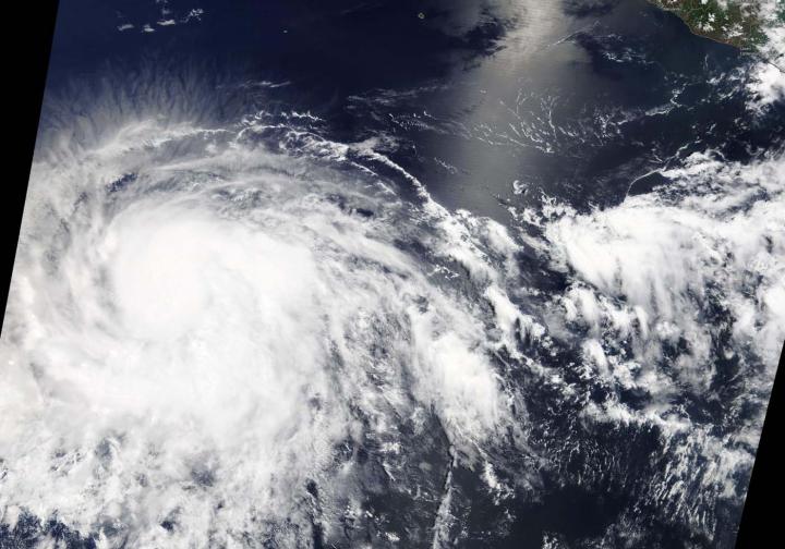
NASA’s Terra and Aqua satellites passed over the Eastern Pacific Ocean after Tropical Storm Barbara strengthened into the first hurricane of the season. Barbara intensified rapidly into a major hurricane.

NOAA’s National Hurricane Center (NHC) noted that Barbara intensified early during the morning of July 2 and could strengthen a little more. Fortunately, Barbara is over 1,000 miles west of the southern tip of Baja California, and there are no coastal watches or warnings in effect.

On July 2, the Moderate Resolution Imaging Spectroradiometer or MODIS instrument aboard NASA’s Terra satellite provided a visible image of Barbara that showed powerful thunderstorms circling an eye. Bands of thunderstorms wrapped into the center from the southern and eastern quadrants.

An infrared look by NASA’s Aqua satellite on July 2, at 5:17 a.m. EDT (0917 UTC revealed where the strongest storms were located within Hurricane Barbara. The Atmospheric Infrared Sounder or AIRS instrument aboard NASA’s Aqua satellite analyzed cloud top temperatures and found cloud top temperatures of strongest thunderstorms as cold as or colder than minus 81.6 degrees Fahrenheit (minus 63.1 degrees Celsius) circling the eye, which was seen in a lighter color in a false-colored NASA image. Cloud top temperatures that cold indicate strong storms that have the capability to create heavy rain.

At 11 a.m. EDT (1500 UTC), the NHC noted the eye of Hurricane Barbara was located near latitude 12.5 degrees north and longitude 122.2 degrees west. Barbara is about 1,080 miles or 1,740 km southwest of the southern tip of Baja California, Mexico. Barbara is moving toward the west-northwest near 14 mph (22 kph). Barbara is forecast to slow in forward speed later today and then turn toward the northwest in a day or two. The estimated minimum central pressure is 948 millibars (28.00 inches).

Satellite data indicate that the maximum sustained winds have increased to near 130 mph (215 kph) with higher gusts.  Barbara is a category 4 hurricane on the Saffir-Simpson Hurricane Wind Scale. Hurricane-force winds extend outward up to 25 miles (35 km) from the center and tropical-storm-force winds extend outward up to 185 miles (295 km).

Some additional strengthening is possible today, but weakening is likely to begin on Wednesday and continue into Thursday.

###

For updated forecasts, visit: http://www.nhc.noaa.gov

By Rob Gutro

NASA’s Goddard Space Flight Center

Media Contact
Rob Gutro
[email protected]

Original Source

https://blogs.nasa.gov/hurricanes/2019/07/02/barbara-eastern-pacific-ocean-2/

Tags: Atmospheric ChemistryAtmospheric ScienceClimate ChangeClimate ScienceEarth ScienceMeteorologyTechnology/Engineering/Computer ScienceTemperature-Dependent PhenomenaWeather/Storms
Share12Tweet8Share2ShareShareShare2

Related Posts

Five or more hours of smartphone usage per day may increase obesity

July 25, 2019
IMAGE

NASA’s terra satellite finds tropical storm 07W’s strength on the side

July 25, 2019

NASA finds one burst of energy in weakening Depression Dalila

July 25, 2019

Researcher’s innovative flood mapping helps water and emergency management officials

July 25, 2019
Please login to join discussion

POPULAR NEWS

  • Blind to the Burn

    Overlooked Dangers: Debunking Common Myths About Skin Cancer Risk in the U.S.

    51 shares
    Share 20 Tweet 13
  • USF Research Unveils AI Technology for Detecting Early PTSD Indicators in Youth Through Facial Analysis

    42 shares
    Share 17 Tweet 11
  • Dr. Miriam Merad Honored with French Knighthood for Groundbreaking Contributions to Science and Medicine

    45 shares
    Share 18 Tweet 11
  • New Measurements Elevate Hubble Tension to a Critical Crisis

    43 shares
    Share 17 Tweet 11

About

We bring you the latest biotechnology news from best research centers and universities around the world. Check our website.

Follow us

Recent News

Advanced Pressure-Velocity Patch Enhances Flight Detection

Durable, Flexible Electrochemical Transistors via Electropolymerized PEDOT

Challenges and Opportunities in High-Filled Polymer Manufacturing

  • Contact Us

Bioengineer.org © Copyright 2023 All Rights Reserved.

Welcome Back!

Login to your account below

Forgotten Password?

Retrieve your password

Please enter your username or email address to reset your password.

Log In
No Result
View All Result
  • Homepages
    • Home Page 1
    • Home Page 2
  • News
  • National
  • Business
  • Health
  • Lifestyle
  • Science

Bioengineer.org © Copyright 2023 All Rights Reserved.