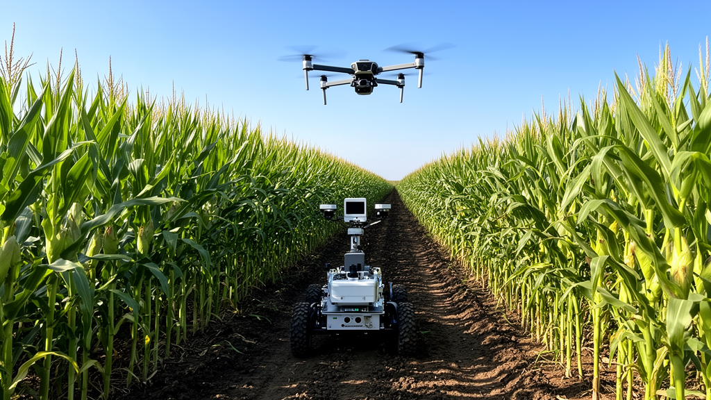
Agricultural engineers have developed an integrated field phenotyping framework that combines unmanned aerial vehicles and autonomous ground rovers to measure critical structural architecture across diverse maize varieties. In field experiments conducted at the Nanfan Experimental Base of the National Nanfan Research Institute in Sanya City, Hainan Province, China, the coordinated multi-platform system successfully extracted plant height, ear height, and the ear height-to-plant height ratio across a breeding population of 823 maize varieties. Plant height and ear placement are central agronomic indicators in cereal breeding, directly influencing canopy light interception, lodging resistance under adverse weather, and mechanical harvesting efficiency. While top-down aerial imagery reliably captures overall canopy elevation, intra-canopy traits such as ear position remain largely shielded from overhead cameras by dense upper foliage. To resolve this observational limitation without relying on labor-intensive manual surveys, the research team paired high-altitude photogrammetry with ground-level depth sensing and customized deep-learning algorithms.
The physical layout of the testing site utilized a plot-based experimental design comprising 823 maize varieties supplied by the Yazhouwan National Laboratory. Each experimental plot was structured with two rows spaced in a wide-narrow configuration, featuring a wide row spacing of 130 centimeters, a narrow row spacing of 35 centimeters, and an intra-row plant spacing of 20 centimeters, with eight plants per row. Data acquisition was conducted in February 2025 during the maturity stage of the crop, when vegetative vertical elongation had stabilized and plant heights ranged from approximately 1.8 to 2.6 meters. During the campaign, manual validation measurements were gathered across 320 representative plots, sampling 2,560 individual plants to provide baseline physical measurements for plant height and ear height.
Aerial data acquisition was performed using a DJI Mini 4 Pro drone equipped with an integrated high-resolution RGB camera operating at a maximum resolution of 8064 by 4536 pixels. The drone followed pre-planned autonomous flight paths maintained at an operational altitude of approximately 20 meters above ground level, capturing oblique imagery with an 80 percent forward and side overlap between adjacent flight lines. Covering the entire experimental area required approximately 30 minutes of total flight time. In post-processing, the resulting aerial collection was processed through Agisoft Metashape software to reconstruct a digital orthomosaic and a three-dimensional digital surface model representing total vegetation elevation. Ground surface elevation was established by selecting over 100 exposed soil points in CloudCompare and applying inverse distance weighting interpolation to yield a digital elevation model. Subtracting the ground elevation model from the surface model produced a canopy height model, from which plot-level plant height was extracted using vector field boundaries in QGIS.
Ground-level measurements were executed simultaneously by a custom-built unmanned ground vehicle equipped with an Intel RealSense D455i depth camera and an onboard NVIDIA Jetson AGX Orin computing unit. The rover traveled between crop rows at a constant traversal velocity of 0.25 meters per second, capturing RGB-D imagery at regular one-second intervals aligned with the drone survey grids. Traversing an individual plot required approximately one minute, including navigational steering and image capture, yielding a curated analysis dataset of 3,218 multi-modal field images. To ensure precise spatial alignment between the independent airborne and terrestrial collections without requiring live telemetry transmission between the platforms, the researchers matched data streams during post-processing using assigned plot identifiers and surveyed boundary records. Ground-truth field teams recorded manual plant height from the soil to the plant apex and ear height from the ground to the ear base, taking between five and eight minutes per plot.
To locate maize ear bases within dense foliage, the researchers designed an optimized pose estimation neural network named LP-YOLO, built upon the YOLOv11 pose baseline architecture. Unlike conventional human pose estimation frameworks that leverage rigid multi-joint skeletal constraints, maize ear pose estimation represents a weak-structure target scenario restricted to only two keypoints: the ear tip and the ear base. In agricultural field conditions, keypoint detection is frequently degraded by shifting natural illumination, soil background clutter, and leaf occlusion. To enhance subtle endpoint representations, the LP-YOLO architecture replaces standard bottleneck blocks with an Adaptive Progressive Fusion Bottleneck. This bottleneck integrates a Progressive Feature Refinement Unit that continuously accumulates fine endpoint cues across multi-stage feature hierarchies, pairing with GSConv modules to maintain cross-channel interaction while preserving lightweight computational efficiency suitable for edge deployment.
Complementing the backbone architecture, the researchers integrated a Lightweight Keypoint Mutual-refinement Module directly into the network prediction head to model bidirectional dependencies between coordinate predictions and confidence features. Standard architectures handle spatial regression and detection confidence as decoupled outputs, which can yield inconsistent localization when background noise from leaf margins or weed textures mimics crop endpoints. The mutual-refinement module establishes bidirectional cross-attention across spatially downsampled feature representations, allowing spatial coordinates to be refined through confidence weights while prediction reliability is verified against structural spatial constraints. Gated residual connections dynamically balance raw and enhanced feature contributions depending on localized occlusion levels. In comparative benchmark testing against RTM-Pose, YOLOv8-Pose, YOLOv10-Pose, and baseline YOLOv11-Pose, LP-YOLO attained the highest detection accuracy, achieving a box precision of 90.8 percent, a box recall of 90.2 percent, a pose precision of 82.9 percent, and a pose recall of 74.4 percent.
Recovering the physical three-dimensional coordinates of ear insertion points required resolving foreground leaf occlusions that distort consumer-grade depth sensors. When foliage crosses the line of sight between the camera and the ear base, registered depth pixels capture the closer foreground leaf rather than the underlying stalk junction. To correct these systematic artifacts, the team implemented a depth-aware compensation algorithm based on local geometric continuity along the longitudinal ear axis. After sampling intermediate depth values between the detected ear tip and base, adjacent depth differentials were evaluated against an empirical discontinuity threshold of 2.5 centimeters. Discontinuities exceeding this value were classified as occlusions, triggering a reconstruction routine that projected depth increments forward from the last unoccluded segment along the ear axis. Among 550 evaluated maize plants, 59.4 percent exhibited unobstructed views, 16.2 percent had mild occlusion, 10.9 percent displayed moderate occlusion, 4.9 percent experienced severe occlusion, and 8.6 percent failed valid estimation.
For absolute height calculation, the ground elevation datum at each plant base was established using root region detections identified by YOLOv11 object bounding boxes. The center points of the lower bounding box edges were projected into three-dimensional camera space to identify candidate soil contact points, which were visually checked and supplemented where necessary to maintain a minimum of six distributed points across the plot. A local ground plane was subsequently fitted to these candidate coordinates using the Random Sample Consensus algorithm with a maximum iteration cap of 1,000 and an inlier distance threshold of 0.02 meters. Individual ear height was calculated as the perpendicular Euclidean distance from the compensated three-dimensional ear base coordinate to the fitted planar equation. Plot-level ear height estimates were derived by averaging valid individual plant measurements within each respective plot.
Validation across independent test plots demonstrated high estimation fidelity between the automated multi-platform phenotyping system and manual field measurements. For plant height, linear regression across 100 validation plots yielded a coefficient of determination of 0.92, a root mean square error of 6.82 centimeters, and a mean absolute error of 5.31 centimeters, with over 90 percent of errors falling within a range of plus or minus 10 centimeters. For ear height, ground rover observations achieved an R-squared of 0.86, a root mean square error of 4.89 centimeters, and a mean absolute error of 3.96 centimeters, outperforming earlier LiDAR-based canopy penetration studies that reported R-squared values between 0.46 and 0.54 with errors exceeding 18 centimeters. Evaluating the depth compensation routine independently on 176 ear-base-occluded specimens revealed a 41.5 percent drop in overall root mean square error, falling from 9.05 centimeters uncompensated down to 5.30 centimeters following geometric depth reconstruction.
Combining aerial plant height and ground-level ear height enabled plot-scale calculation of the ear height-to-plant height ratio, yielding a coefficient of determination of 0.82, a root mean square error of 0.0531, and a mean absolute error of 0.012 when compared with manual measurements. Spatial heatmap analysis across the breeding nursery revealed that while absolute plant height was primarily concentrated between 2.1 and 2.4 meters and showed lower values along outer field boundaries, the ear height ratio exhibited relative independence from absolute plant height variations. Because the normalized ratio dampens localized environmental noise and microclimate gradients, it offers a robust physiological metric for selecting lodging-resistant plant architecture across extensive germplasm collections.
The authors noted several operational limitations and practical boundaries associated with the dual-platform framework. The geometric depth compensation routine requires at least one reliable unoccluded segment along the ear body; instances where extreme biomass completely obscures the entire ear cannot be resolved computationally. Future developments aim to compress LP-YOLO using pruning and distillation for live edge inference on the Jetson AGX Orin platform, integrate multi-view side-scanning geometries, and extend static maturity surveys into multi-temporal four-dimensional phenotyping across progressive vegetative stages.
Subject of Research: High-throughput field phenotyping of maize structural traits using coordinated unmanned aerial and ground vehicles
Article Title: An air-ground phenotyping framework for precise estimation of maize structural traits
Article References: Li, R., Wang, Z., Li, H., Shen, J., Xu, M., Zhou, G., & Zhang, J. (2026). An air-ground phenotyping framework for precise estimation of maize structural traits. Smart Agricultural Technology, 15, Article 102707. https://doi.org/10.1016/j.atech.2026.102707
Image Credits: AI Generated
DOI: 10.1016/j.atech.2026.102707
Keywords: Maize Phenotyping, Unmanned Aerial Vehicles, Unmanned Ground Vehicles, Agricultural Robotics, Computer Vision, Plant Architecture, Crop Breeding, Remote Sensing, air-ground, phenotyping, framework, precise
News Source: Alan Morgan. (November 9, 2026). Autonomous Drone and Rover System Measures Maize Traits in Field Trials. Scienmag.