• HOME
  • NEWS
  • EXPLORE
    • CAREER
      • Companies
      • Jobs
    • EVENTS
    • iGEM
      • News
      • Team
    • PHOTOS
    • VIDEO
    • WIKI
  • BLOG
  • COMMUNITY
    • FACEBOOK
    • INSTAGRAM
    • TWITTER
Friday, August 1, 2025
BIOENGINEER.ORG
No Result
View All Result
  • Login
  • HOME
  • NEWS
  • EXPLORE
    • CAREER
      • Companies
      • Jobs
        • Lecturer
        • PhD Studentship
        • Postdoc
        • Research Assistant
    • EVENTS
    • iGEM
      • News
      • Team
    • PHOTOS
    • VIDEO
    • WIKI
  • BLOG
  • COMMUNITY
    • FACEBOOK
    • INSTAGRAM
    • TWITTER
No Result
View All Result
Bioengineer.org
No Result
View All Result
Home NEWS Science News

A nighttime view of Tropical Storm Hernan from a NASA-NOAA satellite

Bioengineer by Bioengineer
August 27, 2020
in Science News
Reading Time: 3 mins read
0
Share on FacebookShare on TwitterShare on LinkedinShare on RedditShare on Telegram

IMAGE

Credit: NASA Worldview, Earth Observing System Data and Information System (EOSDIS)

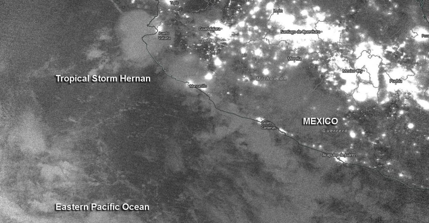
Nighttime imagery from NASA-NOAA’s Suomi NPP satellite revealed the Eastern Pacific Ocean’s Tropical Storm Hernan along the coast of western Mexico. By the weekend, Hernan is expected to absorb nearby Tropical Storm Iselle.

Tropical Depression 13E formed by 5 a.m. EDT on Aug. 26 in the Eastern Pacific. Twelve hours later it strengthened to a tropical storm and was renamed Hernan.

NASA’s Night-Time View

The Visible Infrared Imaging Radiometer Suite (VIIRS) instrument aboard Suomi NPP provided a nighttime image of Hernan on Aug. 26 at 10 p.m. EDT (Aug. 27 at 0000 UTC).

At 5 a.m. EDT on Aug. 27, the National Hurricane Center noted, “Although Hernan is a sheared tropical cyclone, another strong burst of deep convection with cloud tops of minus 83 to minus 86 degrees Celsius has developed near and south through west of the center.” NASA research has shown that cloud tops that cold have the ability to generate heavy rainfall. By 11 a.m. EDT, first light visible satellite imagery reveals that Hernan remains a sheared tropical cyclone with most of the deep convection confined to the western semicircle.

Hernan’s Status of Aug. 27

At 11 a.m. EDT (1500 UTC) NOAA’s National Hurricane Center noted the center of Tropical Storm Hernan was located near latitude 19.1 degrees north and longitude 106.2 degrees west. That is 95 miles (155 km) southwest of Cabo Corrientes, Mexico. Hernan was moving toward the north-northwest near 5 mph (7 kph). Maximum sustained winds are near 45 mph (75 km/h) with higher gusts. The estimated minimum central pressure is 1001 millibars.

Hernan’s Forecast Track

NHC predicts Hernan will turn to the northwest, along with an increase in forward speed is expected to occur by tonight. A turn to the west is forecast this weekend. On the forecast track, the center of Hernan, along with the strongest winds and heaviest rains, is expected to remain just offshore of the southwestern coast of Mexico. Nearby Tropical Storm Iselle is expected to begin weakening on Friday, and the system is forecast to degenerate into a remnant low-pressure area on Saturday. Iselle’s remnants are expected to be absorbed by the circulation of Hernan to its west on Sunday.

###

About NASA’s EOSDIS Worldview

NASA’s Earth Observing System Data and Information System (EOSDIS) Worldview application provides the capability to interactively browse over 700 global, full-resolution satellite imagery layers and then download the underlying data. Many of the available imagery layers are updated within three hours of observation, essentially showing the entire Earth as it looks “right now.”

NASA Researches Earth from Space

For more than five decades, NASA has used the vantage point of space to understand and explore our home planet, improve lives and safeguard our future. NASA brings together technology, science, and unique global Earth observations to provide societal benefits and strengthen our nation. Advancing knowledge of our home planet contributes directly to America’s leadership in space and scientific exploration.

For updated forecasts, visit: http://www.nhc.noaa.gov

By Rob Gutro

NASA’s Goddard Space Flight Center

Media Contact
Rob Gutro
[email protected]

Original Source

https://blogs.nasa.gov/hurricanes/2020/08/27/hernan-eastern-pacific-ocean/

Tags: Atmospheric ChemistryAtmospheric ScienceClimate ChangeClimate ScienceEarth ScienceMeteorologyTechnology/Engineering/Computer ScienceTemperature-Dependent PhenomenaWeather/Storms
Share12Tweet8Share2ShareShareShare2

Related Posts

blank

Integrating Genetics, Modeling, and Climate Data: A Breakthrough Method for Predicting Rice Flowering

August 1, 2025
Hollings Researchers Demonstrate How Natural Language Processing Enhances Medical Practice

Hollings Researchers Demonstrate How Natural Language Processing Enhances Medical Practice

August 1, 2025

Developing Neonatal Point-of-Care Ultrasound Programs

August 1, 2025

DCAF13 Crucial for Mouse Uterine Function, Fertility

August 1, 2025
Please login to join discussion

POPULAR NEWS

  • Blind to the Burn

    Overlooked Dangers: Debunking Common Myths About Skin Cancer Risk in the U.S.

    60 shares
    Share 24 Tweet 15
  • Dr. Miriam Merad Honored with French Knighthood for Groundbreaking Contributions to Science and Medicine

    46 shares
    Share 18 Tweet 12
  • Study Reveals Beta-HPV Directly Causes Skin Cancer in Immunocompromised Individuals

    37 shares
    Share 15 Tweet 9
  • Sustainability Accelerator Chooses 41 Promising Projects Poised for Rapid Scale-Up

    35 shares
    Share 14 Tweet 9

About

We bring you the latest biotechnology news from best research centers and universities around the world. Check our website.

Follow us

Recent News

Integrating Genetics, Modeling, and Climate Data: A Breakthrough Method for Predicting Rice Flowering

Hollings Researchers Demonstrate How Natural Language Processing Enhances Medical Practice

Developing Neonatal Point-of-Care Ultrasound Programs

  • Contact Us

Bioengineer.org © Copyright 2023 All Rights Reserved.

Welcome Back!

Login to your account below

Forgotten Password?

Retrieve your password

Please enter your username or email address to reset your password.

Log In
No Result
View All Result
  • Homepages
    • Home Page 1
    • Home Page 2
  • News
  • National
  • Business
  • Health
  • Lifestyle
  • Science

Bioengineer.org © Copyright 2023 All Rights Reserved.