• HOME
  • NEWS
  • EXPLORE
    • CAREER
      • Companies
      • Jobs
    • EVENTS
    • iGEM
      • News
      • Team
    • PHOTOS
    • VIDEO
    • WIKI
  • BLOG
  • COMMUNITY
    • FACEBOOK
    • INSTAGRAM
    • TWITTER
Thursday, October 23, 2025
BIOENGINEER.ORG
No Result
View All Result
  • Login
  • HOME
  • NEWS
  • EXPLORE
    • CAREER
      • Companies
      • Jobs
        • Lecturer
        • PhD Studentship
        • Postdoc
        • Research Assistant
    • EVENTS
    • iGEM
      • News
      • Team
    • PHOTOS
    • VIDEO
    • WIKI
  • BLOG
  • COMMUNITY
    • FACEBOOK
    • INSTAGRAM
    • TWITTER
No Result
View All Result
Bioengineer.org
No Result
View All Result
Home NEWS Science News

A NASA-NOAA nighttime view finds a slightly better organized tropical storm Karina

Bioengineer by Bioengineer
September 15, 2020
in Science News
Reading Time: 3 mins read
0
IMAGE
Share on FacebookShare on TwitterShare on LinkedinShare on RedditShare on Telegram

IMAGE

Credit: Credit: NASA Worldview, Earth Observing System Data and Information System (EOSDIS)

NASA-NOAA’s Suomi NPP satellite provided an infrared look at Tropical Storm Karina in the Eastern Pacific Ocean that gave forecasters a nighttime view of the storm. It revealed a slightly more organized tropical storm.

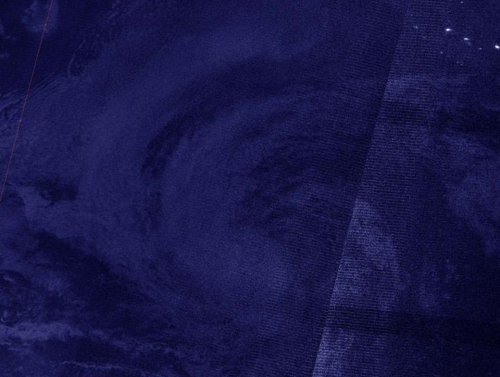
NASA’s Night-Time View  

On Sept. 15 at 6:50 a.m. EDT (3:50 a.m. PDT/1050 UTC), the Visible Infrared Imaging Radiometer Suite (VIIRS) instrument aboard Suomi NPP passed over the Eastern Pacific Ocean and captured an early morning image of Tropical Storm Karina. The image showed that Karina continued to become a little better organized with a concentrated area of deep convection near and over the estimated low-level center. The image was created using the NASA Worldview application at NASA’s Goddard Space Flight Center in Greenbelt, Md.

By 11 a.m. EDT (8 a.m. PDT) on Sept. 15, Andrew Latto, Hurricane Specialist at NOAA’s National Hurricane Center in Miami, Fla. noted in the storm’s Discussion, “Karina has changed little in organization over the past several hours. [It has] a concentrated area of deep convection mostly over the southwestern portion of the circulation and over the estimated position of the low-level center.”

Karina’s Status on Sept. 15

At 11 a.m. EDT (1500 UTC), the center of Tropical Storm Karina was located near latitude 20.4 degrees north and longitude 121.1 degrees west. That is about 740 miles (1,190 km) west of the southern tip of Baja California, Mexico.

Karina was moving toward the northwest near 10 mph (17 kph), and this motion is expected to continue for the next couple of days. A turn to the west and then toward the west-southwest is expected late this week. Maximum sustained winds were near 60 mph (95 kph) with higher gusts. Some weakening is forecast during the next 48 hours. The estimated minimum central pressure was 996 millibars.

Karina’s Forecast

“The cyclone is forecast to move over progressively cooler waters and into a drier, more stable atmosphere over the next couple of days. These conditions should induce a weakening trend soon, and the deep convection is expected to gradually wane during that time,” Latto said in the Discussion.

Gradual weakening should begin by tonight, and Karina is forecast to become a remnant low in two or three days.

###

About NASA’s EOSDIS Worldview

NASA’s Earth Observing System Data and Information System (EOSDIS) Worldview application provides the capability to interactively browse over 700 global, full-resolution satellite imagery layers and then download the underlying data. Many of the available imagery layers are updated within three hours of observation, essentially showing the entire Earth as it looks “right now.”

NASA Researches Earth from Space

For more than five decades, NASA has used the vantage point of space to understand and explore our home planet, improve lives and safeguard our future. NASA brings together technology, science, and unique global Earth observations to provide societal benefits and strengthen our nation. Advancing knowledge of our home planet contributes directly to America’s leadership in space and scientific exploration.

For updated forecasts, visit: http://www.hurricanes.gov

By Rob Gutro 

NASA’s Goddard Space Flight Center

Media Contact
Rob Gutro
[email protected]

Original Source

https://blogs.nasa.gov/hurricanes/2020/09/15/karina-eastern-pacific-2/

Tags: Atmospheric ChemistryAtmospheric ScienceClimate ChangeClimate ScienceEarth ScienceMeteorologyTechnology/Engineering/Computer ScienceTemperature-Dependent PhenomenaWeather/Storms
Share12Tweet8Share2ShareShareShare2

Related Posts

Tidal Volume and Peak Pressure: Key Predictors in Jet Ventilation

Tidal Volume and Peak Pressure: Key Predictors in Jet Ventilation

October 23, 2025
TU Graz Explores Preservation of Endangered Cultural Heritage in the Western Himalayas

TU Graz Explores Preservation of Endangered Cultural Heritage in the Western Himalayas

October 23, 2025

SARS-CoV-2 mRNA Vaccines Boost Tumor Immunotherapy

October 23, 2025

Global Coral Phylogeny Unveils Ancient Resilience, Risks

October 23, 2025
Please login to join discussion

POPULAR NEWS

  • Sperm MicroRNAs: Crucial Mediators of Paternal Exercise Capacity Transmission

    1275 shares
    Share 509 Tweet 318
  • Stinkbug Leg Organ Hosts Symbiotic Fungi That Protect Eggs from Parasitic Wasps

    307 shares
    Share 123 Tweet 77
  • ESMO 2025: mRNA COVID Vaccines Enhance Efficacy of Cancer Immunotherapy

    159 shares
    Share 64 Tweet 40
  • New Study Suggests ALS and MS May Stem from Common Environmental Factor

    132 shares
    Share 53 Tweet 33

About

We bring you the latest biotechnology news from best research centers and universities around the world. Check our website.

Follow us

Recent News

Tidal Volume and Peak Pressure: Key Predictors in Jet Ventilation

TU Graz Explores Preservation of Endangered Cultural Heritage in the Western Himalayas

SARS-CoV-2 mRNA Vaccines Boost Tumor Immunotherapy

Subscribe to Blog via Email

Enter your email address to subscribe to this blog and receive notifications of new posts by email.

Join 66 other subscribers
  • Contact Us

Bioengineer.org © Copyright 2023 All Rights Reserved.

Welcome Back!

Login to your account below

Forgotten Password?

Retrieve your password

Please enter your username or email address to reset your password.

Log In
No Result
View All Result
  • Homepages
    • Home Page 1
    • Home Page 2
  • News
  • National
  • Business
  • Health
  • Lifestyle
  • Science

Bioengineer.org © Copyright 2023 All Rights Reserved.