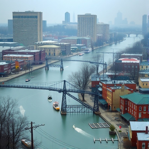
As climate change accelerates, the patterns of extreme weather events are undergoing a profound transformation, not least in the way urban centers experience flooding. Philadelphia, with its complex interface between river systems and dense urban infrastructure, has become an important case study illuminating the intricate dynamics of climate-induced flooding. Recent interdisciplinary research led by the University of Pennsylvania has constructed one of the most granular flood models ever developed for a major city, revealing how the convergence of rising climate extremes and urban development is pushing the Schuylkill River basin toward critical flood tipping points.
The increased frequency, intensity, and scale of flooding that Philadelphia witnessed during Hurricane Ida in 2021 exposed how deeply vulnerable the city is to climate-driven hydrological shocks. Unlike traditional flood events expected to occur once every half-century, such severe flooding now transpires on timescales as short as three years, a stark indicator of how the baseline hydrological environment has shifted. This emerging reality calls for a reexamination of the classical return intervals that planners and engineers use to prepare for flood risks. The Penn team’s research examines this phenomenon through an enhanced high-resolution model, which goes beyond conventional coarse-grained simulations, effectively capturing the detailed interaction between the river, urban infrastructure, and extreme rainfall.
The crux of the study involves identifying a “tipping point” in flood behavior that coincides with the 1-in-100-year flood event threshold. Once river levels exceed this critical boundary, floodwaters no longer remain confined by channel banks but cascade rapidly and uncontrollably into neighborhoods, overwhelming existing mitigation measures. This nonlinear response signifies not just an intensification in flood severity but also a fundamental regime shift in urban flood dynamics. Through meticulously integrating hydrological data with 3D LiDAR terrain models and detailed land-use classification, the researchers have achieved a street-level understanding of flooding patterns, exposing hotspots of vulnerability that standard models typically overlook.
Philadelphia’s urban fabric, characterized by a dense overlay of impervious surfaces such as asphalt and concrete, drastically limits the natural infiltration of stormwater, converting nearly all precipitation from intense storms into immediate surface runoff. This imperviousness, combined with the city’s aging and constrained drainage infrastructure, acts as a bottleneck, impeding water evacuation and causing protracted inundation in low-lying districts. Moreover, buildings, roads, bridges, and artificial levees collectively form labyrinthine barriers that trap floodwaters, exacerbating their persistence long after rainfall has ceased. Such findings underscore how urbanization compounds climate impacts, transforming natural hydrological events into urban disasters with amplified spatial reach and duration.
One of the most striking revelations from the economic analysis embedded in this study involves the unusual vulnerability profile of Philadelphia’s communities with respect to flood risk. Both the city’s wealthiest and most socioeconomically marginalized populations face elevated exposure levels, albeit driven by distinct structural factors. Affluent neighborhoods often experience flood risk due to infrastructural weight causing ground subsidence and extensive impermeable development, while poorer communities suffer from systemic underinvestment, housing affordability pressures, and inadequate flood preparedness. This dual exposure underscores the need for nuanced, equity-centered resilience policies that recognize the heterogeneity of flood risk drivers across socioeconomic spectra.
The disaster loan data analyzed in this research further highlight gaps in current mitigation and recovery frameworks. Federal disaster assistance, as it currently stands, falls significantly short of addressing the scale and distribution of flood-related damages in Philadelphia, pointing to systemic underfunding and inefficiencies that leave many residents underprotected. This discrepancy between damage magnitude and relief efforts exacerbates long-term economic and social inequities, and demands coordinated interventions at federal, state, and local levels informed by scientific insight.
Beyond the immediate devastation wrought by floodwaters, the study sheds light on a less visible, yet equally pernicious, aftermath: environmental contamination and public health hazards from trapped floodwaters in urban basins. Floodwaters in Philadelphia frequently carry a complex cocktail of pollutants including sewage, human waste, and riverine contaminants into city streets, where thick sediment deposits dry into dust layers with potential airborne toxicity. This protracted contamination represents a persistent health hazard that often escapes routine disaster discourse but demands urgent attention. If unaddressed, these residues can catalyze outbreaks of disease and chronic respiratory problems, especially in vulnerable urban populations.
Given the impracticality of retreating from the Schuylkill River’s densely inhabited corridor, the research recommends an integrated approach emphasizing green infrastructure as a long-term resilience strategy. This paradigm shift involves redesigning urban landscapes to incorporate permeable surfaces and engineered natural features that act as water sponges, helping to absorb runoff and attenuate flood peaks. Such blue-green innovations, including constructed wetlands, rain gardens, and enhanced green roofs, could transform the city’s role from flood victim to flood manager, harmonizing urban living with the hydrological realities of a warming climate.
The research team aims to propel these insights into actionable forecasting tools by developing an AI-driven “digital twin” of the Philadelphia flood model. This digital twin will leverage comprehensive physical models and real-time data inputs to produce rapid, precise street-level flood predictions as storms unfold, reducing response times from days to minutes. Such advanced modeling capabilities, when integrated with emergency response protocols, could revolutionize urban flood management by enabling proactive, data-informed decision-making that minimizes human and economic losses.
At the technical core, this research applied autonomous surface vehicle mapping for high-resolution bathymetric data acquisition of the Schuylkill Riverbed, capturing important micro-topography obscured in larger-scale surveys. Advanced LiDAR surveys allowed reconstruction of detailed urban terrain, including buildings and infrastructure footprints, furnishing the model with the granularity essential for resolving local flood dynamics. The integration of multidisciplinary expertise spanning geophysics, climate science, robotics, and economics highlighted how collaborative efforts can yield holistic understandings of complex urban-climate systems.
This work not only pushes the frontiers of urban hydrology but also highlights the profound challenge climate extremes pose to existing urban planning and infrastructure paradigms. Cities like Philadelphia must confront an evolving flood regime that defies traditional engineering assumptions, urging the development of adaptive, resilient frameworks grounded in dynamic scientific observation. By demonstrating the interconnectedness of climate change, urban design, and socioeconomic vulnerability, this research offers a crucial roadmap for metropolitan regions confronting the realities of the climate crisis.
Reflecting on Hurricane Ida’s impact through this scientific lens reveals how extreme weather acts as a stress test that exposes the limitations of current urban infrastructure and disaster preparedness. The insights gained point decisively toward the necessity of evolving from reactive disaster response towards anticipatory, integrated water management strategies that embrace the coupled forces of climate and urbanization. In this sense, Philadelphia’s ordeal provides both a cautionary tale and an opportunity—a call to innovate and adapt in order to safeguard cities at the frontline of climate change.
As cities globally face accelerating urbanization combined with intensifying climate extremes, the frameworks developed in this study have broad applicability. Urban planners, policymakers, and scientists must work in concert to harness high-resolution models and cutting-edge computational tools to anticipate tipping points, manage flood risks, and promote social equity. Failure to do so risks recurrent humanitarian crises and exacerbated environmental degradation, underscoring the imperative of translating science into robust, actionable urban resilience.
Subject of Research: Not applicable
Article Title: Climate extremes and urbanization drive flood tipping points at the city–river interface
News Publication Date: 25-Feb-2026
Web References: http://dx.doi.org/10.1038/s44304-026-00186-8
References: Natural Hazards (journal)
Image Credits: Not specified
Keywords: Extreme weather events, Hurricanes, Tornadoes, Weather forecasting, Weather simulations, Climate change, Climate data, Climate systems, Groundwater, Estuaries, Watersheds, Economics research, Developmental economics, Socioeconomics, Robotics, Mechanical engineering, Robot control
Tags: changing flood return intervalsclimate change impact on urban floodingclimate extremes and urban developmentclimate-induced hydrological shocksextreme weather event frequency increaseflood risk management in citiesgranular flood prediction modelshigh-resolution urban flood modelingHurricane Ida 2021 Philadelphia floodinterdisciplinary flood research PhiladelphiaSchuylkill River flood dynamicsurban infrastructure flood vulnerability
