• HOME
  • NEWS
  • EXPLORE
    • CAREER
      • Companies
      • Jobs
    • EVENTS
    • iGEM
      • News
      • Team
    • PHOTOS
    • VIDEO
    • WIKI
  • BLOG
  • COMMUNITY
    • FACEBOOK
    • INSTAGRAM
    • TWITTER
Wednesday, October 1, 2025
BIOENGINEER.ORG
No Result
View All Result
  • Login
  • HOME
  • NEWS
  • EXPLORE
    • CAREER
      • Companies
      • Jobs
        • Lecturer
        • PhD Studentship
        • Postdoc
        • Research Assistant
    • EVENTS
    • iGEM
      • News
      • Team
    • PHOTOS
    • VIDEO
    • WIKI
  • BLOG
  • COMMUNITY
    • FACEBOOK
    • INSTAGRAM
    • TWITTER
No Result
View All Result
Bioengineer.org
No Result
View All Result
Home NEWS Science News

NASA satellite finds Haishen now a super typhoon

Bioengineer by Bioengineer
September 4, 2020
in Science News
Reading Time: 2 mins read
0
IMAGE
Share on FacebookShare on TwitterShare on LinkedinShare on RedditShare on Telegram

IMAGE

Credit: NASA Worldview, Earth Observing System Data and Information System (EOSDIS)

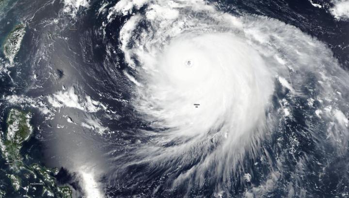
NASA-NOAA’s Suomi NPP satellite passed over the Philippine Sea on Sept. 4 and provided a visible image of Haishen that had strengthened into a super typhoon.

The Visible Infrared Imaging Radiometer Suite (VIIRS) instrument aboard Suomi NPP provided a visible image of Haishen that revealed a large, circular, organized structure of strong thunderstorms circling the open eye. The eyewall, the strong thunderstorms that circle the open eye, is estimated to be 81 nautical miles-wide. Satellite data indicate the eye is about 31 nautical miles wide. The storm is at least 450 miles in diameter, as tropical storm-force winds extend up to 225 miles from the center.

The Joint Typhoon Warning Center (JTWC) in Honolulu, Hawaii noted at 5 a.m. EDT (0900 UTC) on Sept. 4, that Super Typhoon Haishen had maximum sustained winds near 135 knots (155 mph/250 kph). It is currently a Category 4 hurricane/typhoon. It was centered near latitude 22.2 degrees north and longitude 134.3 degrees east, about 439 nautical miles southeast of Kadena Air Base, Okinawa Island, Japan. The storm was moving to the northwest.

JTWC forecasters expect Haishen will turn to the north-northwest while intensifying more. It is expected to peak later on Sept. 4 with sustained winds near 140 knots (161 mph/259 kph) which would make it equivalent to a Category 5 hurricane on the Saffir-Simpson Hurricane Wind Scale. JWTC forecasts Haishen to pass west of Kyushu, Japan and make landfall in South Korea after 3 days.

###

NASA Researches Tropical Cyclones

Hurricanes/tropical cyclones are the most powerful weather events on Earth. NASA’s expertise in space and scientific exploration contributes to essential services provided to the American people by other federal agencies, such as hurricane weather forecasting.

For more than five decades, NASA has used the vantage point of space to understand and explore our home planet, improve lives and safeguard our future. NASA brings together technology, science, and unique global Earth observations to provide societal benefits and strengthen our nation. Advancing knowledge of our home planet contributes directly to America’s leadership in space and scientific exploration.

By Rob Gutro 

NASA’s Goddard Space Flight Center

Media Contact
Rob Gutro
[email protected]

Original Source

https://blogs.nasa.gov/hurricanes/2020/09/04/haishen-northwestern-pacific-ocean-3/

Tags: Atmospheric ChemistryAtmospheric ScienceClimate ChangeClimate ScienceEarth ScienceMeteorologyTechnology/Engineering/Computer ScienceTemperature-Dependent PhenomenaWeather/Storms
Share13Tweet8Share2ShareShareShare2

Related Posts

Decoding Molecular Learning with Hypergraph Insights

October 1, 2025

Correlated CDC20, UBCH10 Signal Poor Cancer Prognosis

October 1, 2025

Dual Dynamic Helical Poly(disulfide)s: Adaptive, Recyclable Polymers

October 1, 2025

Clinicopathological and Molecular Insights into Synovial Sarcoma

October 1, 2025
Please login to join discussion

POPULAR NEWS

  • New Study Reveals the Science Behind Exercise and Weight Loss

    New Study Reveals the Science Behind Exercise and Weight Loss

    89 shares
    Share 36 Tweet 22
  • Physicists Develop Visible Time Crystal for the First Time

    74 shares
    Share 30 Tweet 19
  • How Donor Human Milk Storage Impacts Gut Health in Preemies

    62 shares
    Share 25 Tweet 16
  • Scientists Discover and Synthesize Active Compound in Magic Mushrooms Again

    57 shares
    Share 23 Tweet 14

About

We bring you the latest biotechnology news from best research centers and universities around the world. Check our website.

Follow us

Recent News

Decoding Molecular Learning with Hypergraph Insights

Correlated CDC20, UBCH10 Signal Poor Cancer Prognosis

Dual Dynamic Helical Poly(disulfide)s: Adaptive, Recyclable Polymers

Subscribe to Blog via Email

Enter your email address to subscribe to this blog and receive notifications of new posts by email.

Join 59 other subscribers
  • Contact Us

Bioengineer.org © Copyright 2023 All Rights Reserved.

Welcome Back!

Login to your account below

Forgotten Password?

Retrieve your password

Please enter your username or email address to reset your password.

Log In
No Result
View All Result
  • Homepages
    • Home Page 1
    • Home Page 2
  • News
  • National
  • Business
  • Health
  • Lifestyle
  • Science

Bioengineer.org © Copyright 2023 All Rights Reserved.