Credit: Credit: NASA/ISS/Chris Cassidy
NASA provided a series of photos of Hurricane Genevieve as it affected Mexico’s southern Baja California peninsula. An astronaut aboard the International Space Station provided wide-angle photos of Genevieve, showing the size of the storm. Warnings and watches are in effect on Aug. 20.
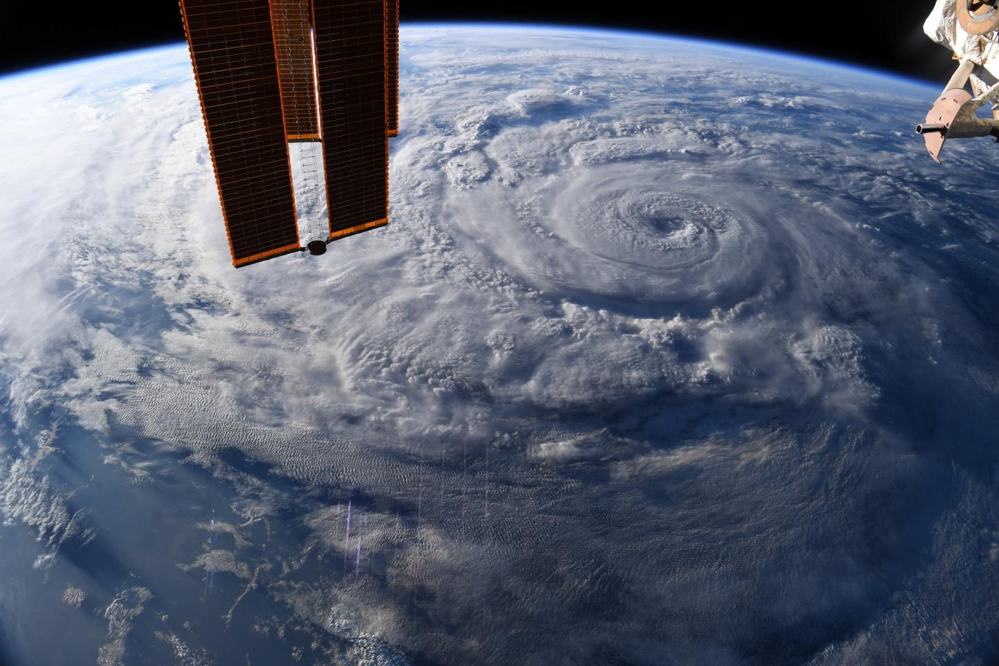
International Space Station Astronaut Chris Cassidy snapped photos of the Eastern Pacific Ocean’s Hurricane Genevieve on Aug 19, 2020 at 4 p.m. EDT. The photos revealed a clear eye surrounded by a ring of powerful thunderstorms. At the time of the photo Genevieve’s tropical-storm force winds extended out 280 miles. By Aug. 20 as the storm weakened, its wind field expanded and hurricane-force winds extended outward up to 30 miles (45 km) from the center and tropical-storm-force winds extended outward up to 115 miles (185 km).
On Aug. 20, Genevieve was moving in a northerly direction, paralleling the coast of Baja California Sur.
Warnings and Watches on Aug. 20
On Thursday, August 20, 2020, NOAA’s National Hurricane Center (NHC) posted a Tropical Storm Warning for Mexico’s Baja California peninsula from Los Barriles to Cabo San Lazaro. A Tropical Storm Watch is in effect for the east coast of the Baja California peninsula from Los Barriles to La Paz. At 11 a.m. EDT (1500 UTC), the NHC reported, “Tropical storm conditions have already been occurring along the southern tip of the Baja California peninsula since last night, and these conditions continue to spread northward over the Southern Baja California peninsula, especially over higher terrain.”
Genevieve on Thursday, August 20
At 11 a.m. EDT (1500 UTC), the center of Hurricane Genevieve was located near latitude 23.3 degrees north and longitude 111.4 degrees west. That is about 100 miles (160 km) west-northwest of the southern tip of Baja California and about 120 miles (190 south-southeast of Cabo San Lazaro, Mexico. Genevieve was moving toward the northwest near 12 mph (19 kph) and this motion is expected to continue through Saturday.
Maximum sustained winds are near 75 mph (120 kph) with higher gusts. Further gradual weakening is expected today and through the weekend. However, Genevieve is expected to remain a hurricane through much of today while it passes just to the southwest and west of the southern Baja California peninsula. The estimated minimum central pressure is 984 millibars.
Baja California Hazards
NHC noted the Baja is facing strong winds, heavy rainfall, and large ocean swells. “Tropical storm conditions will spread northward within the warning area in the southern Baja California peninsula through today and may linger into tonight. Tropical storm conditions are possible within the watch area through the early afternoon, especially over higher terrain.
Genevieve is expected to produce additional rainfall amounts of 2 to 4 inches across southern Baja California Sur, with isolated storm totals of 12 inches across far southern Baja California Sur. This rainfall may lead to life-threatening flash flooding and mudslides.
Large swells produced by Genevieve are affecting portions of the west-central coast of Mexico and are spreading northward along the coast of the Baja California peninsula. These swells are likely to cause life-threatening surf and rip current conditions.”
Genevieve’s Forecast Track
The National Hurricane Center forecast said the center of Genevieve is expected to pass just to the southwest and west of the southern portion of the Baja California peninsula today (Aug. 20), and move away from the peninsula on Friday, Aug. 21.
NASA Researches Tropical Cyclones
Hurricanes/tropical cyclones are the most powerful weather events on Earth. NASA’s expertise in space and scientific exploration contributes to essential services provided to the American people by other federal agencies, such as hurricane weather forecasting.
For more than five decades, NASA has used the vantage point of space to understand and explore our home planet, improve lives and safeguard our future. NASA brings together technology, science, and unique global Earth observations to provide societal benefits and strengthen our nation. Advancing knowledge of our home planet contributes directly to America’s leadership in space and scientific exploration.
###
For updated forecasts, visit: http://www.
By Rob Gutro
NASA’s Goddard Space Flight Center
Media Contact
Rob Gutro
[email protected]
Original Source
https:/
