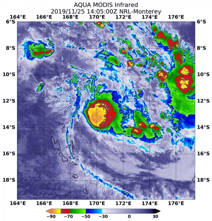
Credit: Credit: NASA/NRL
The tropical cyclone season in the Southern Pacific Ocean has kicked off with Tropical Cyclone Rita, and NASA’s Aqua satellite passed over the storm and analyzed it in infrared light for temperature data.
Rita developed on Nov. 24 as Tropical Cyclone 1P, 452 miles north of Port Vila, Vanuatu. By 10 a.m. EST (1500 UTC) on Nov. 24, Tropical Cyclone 1P strengthened into a tropical storm and was named Rita.
NASA’s Aqua satellite used infrared light to analyze the strength of storms in newly developed Rita. Infrared data provides temperature information, and the strongest thunderstorms that reach high into the atmosphere have the coldest cloud top temperatures. On Nov. 25 at 9:05 a.m. EST (1405 UTC), the Moderate Resolution Imaging Spectroradiometer or MODIS instrument gathered that temperature information. MODIS found a large area of powerful thunderstorms circling Rita’s center with cloud top temperatures as cold as or colder than minus 80 degrees Fahrenheit (minus 62.2 Celsius). Cloud top temperatures that cold indicate strong storms with the potential to generate heavy rainfall.
At the time of the MODIS image, Rita was located northeast of Vanuatu. Because of Rita’s close proximity, there are Vanuatu warnings in effect on Nov. 26. Those warnings include a Red alert is in effect for the Torba province and a Yellow Alert applies to Penama and Sanma provinces.
On Nov. 26 at 10 a.m. EST (1500 UTC), Tropical Cyclone Rita was located near latitude 12.6 degrees south and longitude 170.3 degrees east. That is about 344 nautical miles north-northeast of Port Vila, Vanuatu. Rita was moving to the south-southeast at 3 knots. Maximum sustained winds 60 knots (69 mph/96 kph).
Rita is forecast to move south-southeast. The storm is weakening and is expected to dissipate within three days.
Typhoons and hurricanes are the most powerful weather event on Earth. NASA’s expertise in space and scientific exploration contributes to essential services provided to the American people by other federal agencies, such as hurricane weather forecasting.
###
Media Contact
Rob Gutro
[email protected]
Original Source
https:/


