• HOME
  • NEWS
  • EXPLORE
    • CAREER
      • Companies
      • Jobs
    • EVENTS
    • iGEM
      • News
      • Team
    • PHOTOS
    • VIDEO
    • WIKI
  • BLOG
  • COMMUNITY
    • FACEBOOK
    • INSTAGRAM
    • TWITTER
Monday, October 6, 2025
BIOENGINEER.ORG
No Result
View All Result
  • Login
  • HOME
  • NEWS
  • EXPLORE
    • CAREER
      • Companies
      • Jobs
        • Lecturer
        • PhD Studentship
        • Postdoc
        • Research Assistant
    • EVENTS
    • iGEM
      • News
      • Team
    • PHOTOS
    • VIDEO
    • WIKI
  • BLOG
  • COMMUNITY
    • FACEBOOK
    • INSTAGRAM
    • TWITTER
No Result
View All Result
Bioengineer.org
No Result
View All Result
Home NEWS Science News Science

NASA satellites track Tropical Cyclone Fani along Eastern India’s coastline

Bioengineer by Bioengineer
May 1, 2019
in Science
Reading Time: 2 mins read
0
IMAGE
Share on FacebookShare on TwitterShare on LinkedinShare on RedditShare on Telegram

IMAGE

Credit: NASA Worldview, Earth Observing System Data and Information System (EOSDIS)

NASA’s Aqua and Terra satellites have been providing infrared, microwave and visible imagery of Tropical Cyclone Fani as it continued to move northward along the eastern coast of India.

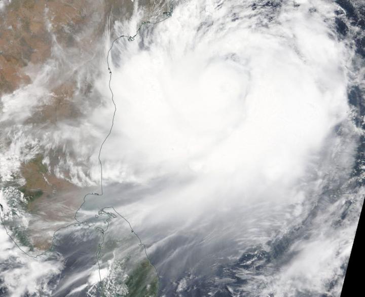
Tropical Cyclone Fani continued to strengthen and move north through the Northern Indian Ocean on April 30 and May 1 when NASA’s Aqua and Terra satellite provided imagery of the strengthening storm. Fani is located off the southeastern coast of India, north of the island of Sri Lanka. Sri Lanka is an island country located southwest of the Bay of Bengal and southeast of the Arabian Sea.

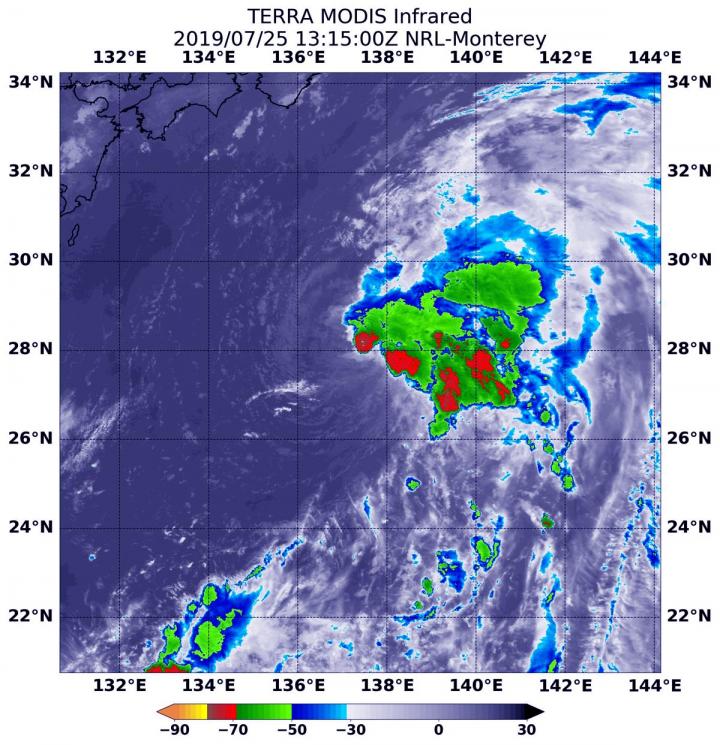
On April 30 at 3:35 a.m. EDT (0735 UTC) the Atmospheric Infrared Sounder or AIRS instrument aboard NASA’s Aqua satellite analyzed cloud top temperatures of Tropical Cyclone Fani in infrared light. AIRS found cloud top temperatures of strongest thunderstorms as cold as or colder than minus 63 degrees Fahrenheit (minus 53 degrees Celsius) circling the center and in a large band east of the center. Cloud top temperatures that cold indicate strong storms that have the capability to create heavy rain.

On May 1, the Moderate Resolution Imaging Spectroradiometer or MODIS instrument aboard NASA’s Terra satellite provided a visible image of Fani. Fani’s center appeared to have an eye obscured by high clouds. Infrared imagery revealed that ragged eye and microwave imagery showed curved bands of thunderstorms wrapping into the eye.

Fani was located off the coast of southeastern India. It was affecting the Coramandal Coast that stretches from the southeastern tip of India to east-central India’s Andhra Coast to the north.

On May 1 at 11 a.m. EST (1500 UTC), the center of Tropical Cyclone Fani was located near latitude 15.2 degrees north and longitude 84.3 degrees east. That is about 520 nautical miles south-southwest of Kolkata, India. Fani was moving to the north and maximum sustained winds were near 105 knots (121 mph/194 kph).

The Joint Typhoon Warning Center expects Fani to continue moving north and intensify slightly as it moves over warm waters. Fani is forecast to move to the north-northeast. The India Meteorological Department forecasts Fani to make landfall along the Odisha coastline between Gopalpur and Chandbali on May 3 at hurricane-strength.

###

For local forecasts, visit the India Meteorological Department: http://www.imd.gov.in/

By Rob Gutro

NASA’s Goddard Space Flight Center

Media Contact
Rob Gutro
[email protected]

Original Source

https://blogs.nasa.gov/hurricanes/2019/05/01/fani-northern-indian-ocean-3/

Tags: Atmospheric ChemistryAtmospheric ScienceClimate ChangeClimate ScienceEarth ScienceMeteorologyTechnology/Engineering/Computer ScienceTemperature-Dependent PhenomenaWeather/Storms
Share14Tweet8Share2ShareShareShare2

Related Posts

Five or more hours of smartphone usage per day may increase obesity

July 25, 2019
IMAGE

NASA’s terra satellite finds tropical storm 07W’s strength on the side

July 25, 2019

NASA finds one burst of energy in weakening Depression Dalila

July 25, 2019

Researcher’s innovative flood mapping helps water and emergency management officials

July 25, 2019
Please login to join discussion

POPULAR NEWS

  • New Study Reveals the Science Behind Exercise and Weight Loss

    New Study Reveals the Science Behind Exercise and Weight Loss

    94 shares
    Share 38 Tweet 24
  • New Study Indicates Children’s Risk of Long COVID Could Double Following a Second Infection – The Lancet Infectious Diseases

    92 shares
    Share 37 Tweet 23
  • New Insights Suggest ALS May Be an Autoimmune Disease

    71 shares
    Share 28 Tweet 18
  • Physicists Develop Visible Time Crystal for the First Time

    75 shares
    Share 30 Tweet 19

About

We bring you the latest biotechnology news from best research centers and universities around the world. Check our website.

Follow us

Recent News

cDC3s Impair Anti-TNF-α Therapy in Ulcerative Colitis

Revolutionary Memory Network Models Ionic-Electronic Interactions

New Survey Reveals Most Americans Recognize Life-Saving Power of Plasma Donation, But Few Have Participated

Subscribe to Blog via Email

Enter your email address to subscribe to this blog and receive notifications of new posts by email.

Join 63 other subscribers
  • Contact Us

Bioengineer.org © Copyright 2023 All Rights Reserved.

Welcome Back!

Login to your account below

Forgotten Password?

Retrieve your password

Please enter your username or email address to reset your password.

Log In
No Result
View All Result
  • Homepages
    • Home Page 1
    • Home Page 2
  • News
  • National
  • Business
  • Health
  • Lifestyle
  • Science

Bioengineer.org © Copyright 2023 All Rights Reserved.