Credit: NOAA-NASA
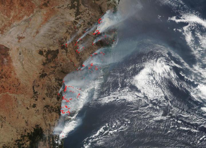
NOAA-NASA’s Suomi NPP satellite flew over the New South Wales fires in Australia on December 16, 2019 and found devastation from the ongoing fires. The New South Wales Rural Fire Service is reporting 96 fires are burning and to date the size of the area burned is 1.5 times the size of the state of Connecticut (approximately 5.3 million acres of land). These fires are largely the result of an atypical drought for the area, increasing temperatures, and low humidity. Coupled with the danger of the fires is the resulting shroud of smog that is currently covering Sydney.
The smoke released by any type of fire (forest, brush, crop, structure, tires, waste or wood burning) is a mixture of particles and chemicals produced by incomplete burning of carbon-containing materials. All smoke contains carbon monoxide, carbon dioxide and particulate matter (PM or soot). Smoke can contain many different chemicals, including aldehydes, acid gases, sulfur dioxide, nitrogen oxides, polycyclic aromatic hydrocarbons (PAHs), benzene, toluene, styrene, metals and dioxins. The type and amount of particles and chemicals in smoke varies depending on what is burning, how much oxygen is available, and the burn temperature.
Exposure to high levels of smoke should be avoided. Individuals are advised to limit their physical exertion if exposure to high levels of smoke cannot be avoided. Individuals with cardiovascular or respiratory conditions (e.g., asthma), infants, young children, and the elderly may be more vulnerable to the health effects of smoke exposure.
NASA’s Ozone Mapping and Profiler Suite (OMPS) is an instrument that flies aboard NASA-NOAA’s Suomi NPP satellite and provides data on ozone. The OMPS Aerosol Index layer (in the image above) indicates the presence of ultraviolet (UV)-absorbing particles in the air (aerosols) such as desert dust and, as in this case, soot particles in the atmosphere; it is related to both the thickness of the aerosol layer located in the atmosphere and to the height of the layer. The Aerosol Index is a unitless range from =5.00, where 5.0 indicates heavy concentrations of aerosols that could reduce visibility or impact human health. The Aerosol Index layer is useful for identifying and tracking the long-range transport of volcanic ash from volcanic eruptions, smoke from wildfires or biomass burning events and dust from desert dust storms, even tracking over clouds and areas of snow and ice. The yellow aerosols can also be seen in the South Pacific Ocean where winds have carried the aerosols away from fires and past New Zealand and beyond.
Aerosols absorb and scatter incoming sunlight, which reduces visibility and increases the optical depth. Aerosols have an effect on human health, weather and the climate. Sources of aerosols include pollution from factories, smoke from fires, dust from dust storms, sea salts, and volcanic ash and smog. Aerosols compromise human health when inhaled by people with asthma or other respiratory illnesses. Aerosols also have an affect on the weather and climate by cooling or warming the earth, helping or preventing clouds from forming.
NASA’s satellite instruments are often the first to detect wildfires burning in remote regions, and the locations of new fires are sent directly to land managers worldwide within hours of the satellite overpass. Together, NASA instruments detect actively burning fires, track the transport of smoke from fires, provide information for fire management, and map the extent of changes to ecosystems, based on the extent and severity of burn scars. NASA has a fleet of Earth-observing instruments, many of which contribute to our understanding of fire in the Earth system. Satellites in orbit around the poles provide observations of the entire planet several times per day, whereas satellites in a geostationary orbit provide coarse-resolution imagery of fires, smoke and clouds every five to 15 minutes. For more information visit: https:/
NASA’s Earth Observing System Data and Information System (EOSDIS) Worldview application provides the capability to interactively browse over 700 global, full-resolution satellite imagery layers and then download the underlying data. Many of the available imagery layers are updated within three hours of observation, essentially showing the entire Earth as it looks “right now.” Actively burning fires, detected by thermal bands, are shown as red points. Image Courtesy: NASA Worldview, Earth Observing System Data and Information System (EOSDIS). Caption: Lynn Jenner with information from New South Wales Rural Fire Service
###
Media Contact
Lynn Jenner
[email protected]
Original Source
https:/

