• HOME
  • NEWS
  • EXPLORE
    • CAREER
      • Companies
      • Jobs
    • EVENTS
    • iGEM
      • News
      • Team
    • PHOTOS
    • VIDEO
    • WIKI
  • BLOG
  • COMMUNITY
    • FACEBOOK
    • INSTAGRAM
    • TWITTER
Thursday, March 26, 2026
BIOENGINEER.ORG
No Result
View All Result
  • Login
  • HOME
  • NEWS
  • EXPLORE
    • CAREER
      • Companies
      • Jobs
        • Lecturer
        • PhD Studentship
        • Postdoc
        • Research Assistant
    • EVENTS
    • iGEM
      • News
      • Team
    • PHOTOS
    • VIDEO
    • WIKI
  • BLOG
  • COMMUNITY
    • FACEBOOK
    • INSTAGRAM
    • TWITTER
No Result
View All Result
Bioengineer.org
No Result
View All Result
Home NEWS Science News Biology

NASA’s Terra Satellite shows smoky pall over most of California

Bioengineer by Bioengineer
August 24, 2020
in Biology
Reading Time: 3 mins read
0
IMAGE
Share on FacebookShare on TwitterShare on LinkedinShare on RedditShare on Telegram

IMAGE

Credit: NASA Worldview

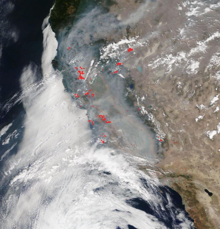
More than 650 wildfires are blazing in California after unprecedented lightning strikes, storms, and a heatwave that has set new records in the state and NASA’s Terra satellite captured the smoke-engulfed state on Aug. 24, 2020.

The two largest fires still burning the state are both named after the firefighting units that are battling them and the fact that both began with lightning strikes. The LNU Lightning Complex and the SCU Lightning Complex are both located in northern California. The LNU (Lake Napa Unit) Lightning Complex has burned 347,630 acres and is 21% contained and the SCU (Santa Clara Unit) Lightning Complex has consumed 343,965 acres and is 10% contained according to the CAL Fire website. These two fires are now second and third on the list of California’s largest wildfires.

Even discounting these fires there are still hundreds of other fires burning across the state as can be seen in this Terra satellite image taken on Aug. 24, 2020. Red dots litter the landscape designating areas which are most likely fires–so many fires, in fact, that the dots blur together and individual fire are no longer visible.

More insidious than the fires is the smoke that rises from the landscape. This aerosol image below shows not only California being affected by the heavy smoke as seen in the visible image above, but the smoke has traveled across much of the United States affecting areas from California all the way to Minnesota and Nebraska and air currents will undoubtedly carry the smoke across the entire U.S.

The aerosol index provides information about the presence of particles in the air. According to NASA Worldview: “The Aerosol Index is a unitless range from =5.00, where 5.0 [deepest red] indicates heavy concentrations of aerosols that could reduce visibility or impact human health. The Aerosol Index layer is useful for identifying and tracking the long-range transport of volcanic ash from volcanic eruptions, smoke from wildfires or biomass burning events and dust from desert dust storms, even tracking over clouds and areas of snow and ice.” In this image deep red areas can be seen in California but can also be seen as far east as Minnesota meaning the heavy aerosols do not necessarily diminish as they travel on the air currents.

###

NASA’s satellite instruments are often the first to detect wildfires burning in remote regions, and the locations of new fires are sent directly to land managers worldwide within hours of the satellite overpass. Together, NASA instruments detect actively burning fires, track the transport of smoke from fires, provide information for fire management, and map the extent of changes to ecosystems, based on the extent and severity of burn scars. NASA has a fleet of Earth-observing instruments, many of which contribute to our understanding of fire in the Earth system. Satellites in orbit around the poles provide observations of the entire planet several times per day, whereas satellites in a geostationary orbit provide coarse-resolution imagery of fires, smoke and clouds every five to 15 minutes. For more information visit: https://www.nasa.gov/mission_pages/fires/main/missions/index.html

Media Contact
Lynn Jenner
[email protected]

Original Source

https://www.nasa.gov/feature/goddard/2020/nasa-s-terra-satellite-shows-smoky-pall-over-most-of-california

Tags: AgricultureAtmospheric ChemistryAtmospheric ScienceClimate ChangeClimate ScienceEarth ScienceForestryPollution/RemediationTemperature-Dependent PhenomenaWeather/Storms
Share12Tweet8Share2ShareShareShare2

Related Posts

How to sway group opinions: Encourage opponents to stay undecided

How to sway group opinions: Encourage opponents to stay undecided

March 23, 2026
Deep Learning Model Maps How Individual Cells Shape Disease Outcomes

Deep Learning Model Maps How Individual Cells Shape Disease Outcomes

March 20, 2026

Removing only 15 female sharks annually could endanger the entire population, scientists warn

March 20, 2026

Scientists Urge Fragrance Industry to Transition from Sustainability Talk to Active Funding of Plant Conservation

March 20, 2026
Please login to join discussion

POPULAR NEWS

  • blank

    Revolutionary AI Model Enhances Precision in Detecting Food Contamination

    96 shares
    Share 38 Tweet 24
  • Imagine a Social Media Feed That Challenges Your Views Instead of Reinforcing Them

    1003 shares
    Share 397 Tweet 248
  • Uncovering Functions of Cavernous Malformation Proteins in Organoids

    54 shares
    Share 22 Tweet 14
  • Promising Outcomes from First Clinical Trials of Gene Regulation in Epilepsy

    51 shares
    Share 20 Tweet 13

About

We bring you the latest biotechnology news from best research centers and universities around the world. Check our website.

Follow us

Recent News

In-Sensor Cryptography Links Physical Process to Digital Identity

Can Psychosocial Factors Influence Cancer Risk?

Depression Factors in Elderly: Pre vs. Post-COVID Analysis

Subscribe to Blog via Email

Success! An email was just sent to confirm your subscription. Please find the email now and click 'Confirm' to start subscribing.

Join 78 other subscribers
  • Contact Us

Bioengineer.org © Copyright 2023 All Rights Reserved.

Welcome Back!

Login to your account below

Forgotten Password?

Retrieve your password

Please enter your username or email address to reset your password.

Log In
No Result
View All Result
  • Homepages
    • Home Page 1
    • Home Page 2
  • News
  • National
  • Business
  • Health
  • Lifestyle
  • Science

Bioengineer.org © Copyright 2023 All Rights Reserved.