Credit: Credits: NASA JPL/Ed Olsen
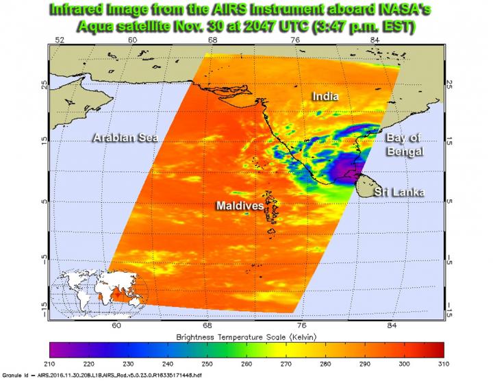
NASA's Aqua satellite flew over Tropical Cyclone Nada in the Northern Indian Ocean and infrared imagery showed that Nada had "nada" in terms of strong thunderstorms.
The Atmospheric Infrared Sounder or AIRS instrument aboard Aqua provided temperature data on Nada on Nov. 30 at 3:47 p.m. EST (2047 UTC). At the time of the overpass, the northwestern quadrant of the storm had already spread over southeastern India and the center was approaching landfall. There was a small area of cold cloud top temperatures (indicating strong thunderstorms) near minus 63 Fahrenheit (minus 53 degrees Celsius) over the Palk Strait. The Palk Strait lies between the Tamil Nadu state of India and the northern province of the island nation of Sri Lanka.
By early Dec. 1, infrared data showed and virtually no associated deep convection (rapidly rising air that creates the thunderstorms that make up a tropical cyclone) or strong thunderstorms.
Animated multispectral satellite on Dec. 1 at 5:49 a.m. EST (1049 UTC) showed that the low-level center of circulation was still symmetric, so the interaction with land had not yet elongated the storm.
The Joint Typhoon Warning Center (JTWC) issued their final warning on Nada on Dec. 1 at 10 a.m. EST (1500 UTC). At that time, Nada's maximum sustained winds were near 35 knots (40 mph/62 kph) and weakening. The storm was centered near 10.5 degrees north latitude and 80.7 degrees east longitude.
Nada is forecast to move west-northwest over southern India. Its remnants are expected to dissipate over land in the next day.
###
Media Contact
Rob Gutro
[email protected]
@NASAGoddard
http://www.nasa.gov/goddard
############
Story Source: Materials provided by Scienmag


