
Credit: Credits: NASA/JAXA, Hal Pierce
Tropical Cyclone Debbie generated a lot of rainfall before and after it made landfall in Queensland, Australia, and NASA analyzed how much rain fell from a vantage point of space. NASA's Terra satellite provided a look at the remnants early on March 30 is it lingered near Australia's Gold Coast.
The MODIS instrument aboard NASA's Terra satellite captured a visible image of the remnants of Tropical Cyclone Debbie over eastern Australia on March 30 at 0000 UTC (Mar. 29 at 8 p.m. EST). The image showed clouds associated with Debbie's remnants stretched from Mackay in Queensland south to Sydney in New South Wales. Debbie's elongated remnants also stretched further south-southeast into the Tasman Sea.
At 10 p.m. AEST (8 a.m. EST/U.S.) on March 30, the Australian Bureau of Meteorology (ABM) noted that Ex-Tropical Cyclone Debbie's remnants were located over land near the Gold Coast. The Gold Coast is located on Australia's east coast and is a metropolitan region south of Brisbane.
Debbie's remnants are expected to continue moving to the southeast. ABM said Debbie's remnants are "likely to strengthen off the northern New South Wales coast as it moves away from the coast during Friday, March 31."
ABM noted on March 30, "Dangerous surf conditions are likely to produce significant beach erosion over coastal parts of southeast Queensland for the rest of Thursday, March 30 and during Friday, March 31. Abnormally high tides are likely about beachfront areas south of Cape Moreton on the high tides during Friday. Locations which may be affected include the Gold Coast, the Sunshine Coast, Stradbroke Island, Moreton Island and Fraser Island." For updated warnings and forecasts, visit: http://www.bom.gov.au/qld/.
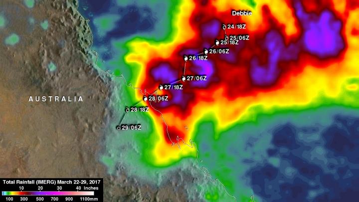
Tropical cyclone Debbie formed in the Coral Sea northeast of Australia on March 24, 2017. Debbie intensified and had hurricane force wind speeds within a day of formation. While headed toward northeastern Australia Debbie reached its maximum sustained wind speeds estimated at over 100 knots (115 mph) on March 27, 2017 (UTC). Tropical cyclone Debbie came ashore on March 28 and brought destructive winds and extremely heavy rain to northeastern Australia. It was reported that heavy rainfall caused flash flooding that cut off a coastal town and covered several roads in Queensland.
The Global Precipitation Measurement mission or GPM satellite viewed Debbie several times during its trek toward Australia. GPM flew over the tropical cyclone in the Coral Sea on March 24 shortly before it was assigned a name. With that pass GPM saw that the forming tropical cyclone was getting organized and contained bands of heavy rainfall south of the center of circulation. Debbie was close to hurricane intensity with bands of very heavy rain spiraling into the tropical cyclone's center when GPM passed over on March 25 at 1436 UTC (10:36 a.m. EST. GPM's Microwave Imager (GMI) showed a Debbie had developed an eye on March 26. Intense bands of rain circling a well-defined eye were revealed by GPM's GMI on March 27, 2017.
The GPM satellite flew above the center of intensifying tropical cyclone Debbie on March 25th. GPM's radar data collected with that pass showed that many storm tops in feeder bands (of thunderstorms) around the tropical cyclone were reaching heights above 13 kilometers (8 miles). GPM is a joint mission between NASA and the Japanese space agency JAXA.
Rainfall data was produced in near-real time at half hourly intervals from NASA's Integrated Multi-satellitE Retrievals for GPM (IMERG) data. The IMERG analysis from March 22 to 29 was created at NASA's Goddard Space Flight Center in Greenbelt, Maryland using data from several satellites in the GPM constellation of satellites. The data were calibrated with measurements from the GPM Core Observatory as well as rain gauge networks around the world.
The analysis covers the period from when Debbie was forming over the Coral Sea until the tropical cyclone dissipated over the interior of northeastern Australia. IMERG indicated that rainfall totals were greater than 500 mm (~ 20 inches) along many parts of Debbie's track. IMERG indicates that the most extreme rainfall fell along the coast where Debbie came ashore. Rainfall totals fell off rapidly as the tropical cyclone moved over land and dissipated. IMERG rainfall totals have been adjusted to reflect observed values in other similar extreme rainfall events.
###
Media Contact
Rob Gutro
[email protected]
@NASAGoddard
http://www.nasa.gov/goddard
############
Story Source: Materials provided by Scienmag
