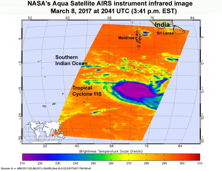
Credit: Credits: NASA JPL/Ed Olsen
Just after Tropical Cyclone 11S formed in the Southern Indian Ocean NASA's Aqua satellite passed overhead gathering data using infrared light. The Atmospheric Infrared Sounder or AIRS instrument aboard NASA's Aqua satellite looked at Tropical Cyclone 11S in infrared light. The AIRS image was taken on Mar. 8 at 20:41 UTC (3:41 p.m. EST) and showed some cloud top temperatures of thunderstorms around the center of circulation as cold as minus 63 degrees Fahrenheit (minus 53 degrees Celsius). NASA research has shown the storms with cloud tops that cold have the potential to generate heavy rainfall.
At 0900 UTC (4 a.m. EST), the Joint Typhoon Warning Center noted that 11S had maximum sustained winds near 46 mph (40 knots/74 kph). It was located about 700 nautical miles east-northeast of Mauritius, near 14.6 degrees south latitude and 68.6 degrees east longitude. 11S was moving to the west-northwest at 11.5 mph (10 knots/18.5 kph).
Tropical Cyclone 11S is forecast to move west then turn southwest, while slowing down. 11S is expected to pass close to Rodrigues Island on Saturday, March 11, and then south of La Reunion Island on March 12. It is forecast to reach hurricane force on March 13. Because of uncertainty in the track forecast, residents of the Mascareigne Islands should monitor closely the progression of this system.
###
Media Contact
Rob Gutro
[email protected]
@NASAGoddard
http://www.nasa.gov/goddard
############
Story Source: Materials provided by Scienmag


