Credit: Credit: NASA/JAXA, Hal Pierce
Tropical Cyclone Alcide dissipated over the weekend of Nov. 11 and 12 in the Southern Indian Ocean.
However, when it was near peak intensity, the Global Precipitation Measurement mission or GPM core satellite provided a look at the rain falling within.
The GPM core observatory satellite, a joint mission between NASA and the Japan Aerospace Exploration Agency, JAXA, had an excellent view of tropical cyclone Alcide on November 8, 2018 at 10:59 a.m. EDT (1559 UTC) after it had moved to a location northeast of Madagascar. At that time Alcide had reached its peak intensity with winds of about 95 knots (109 mph) making it the equivalent of a strong category two hurricane on the Saffir-Simpson hurricane wind scale.
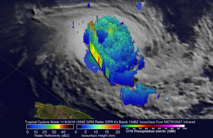
Data collected by GPM's Microwave Imager (GMI) and GPM's Dual-Frequency Precipitation Radar (DPR) instruments revealed that the powerful tropical cyclone was producing extremely heavy rainfall. GPM's radar (DPR Ku Band) indicated that tall convective storms in the northwestern side of Alcide's eyewall were dropping rain at a rate of more than 255 mm (10 inches) per hour.
GPM's radar data (DPR Ku Band) were used to create an image to probe the 3D structure of precipitation within tropical cyclone Alcide. The well-defined eye of the powerful tropical cyclone is revealed with this simulated view from the southwest. GPM's DPR found that the most powerful convective storms were located in tropical cyclone Alcide's western eye wall. A few of these tall storms were found by GPM to reach heights above 16.0 km (9.92 miles).
On Nov. 11, Tropical cyclone Alcide dissipated near 12.3 south latitude and 51.9 east longitude, about 529 miles north-northwest of St Denis, La Reunion.
###
Media Contact
Rob Gutro
[email protected]
@NASAGoddard
http://www.nasa.gov/goddard
Original Source
https://blogs.nasa.gov/hurricanes/tag/alcide-2018/


