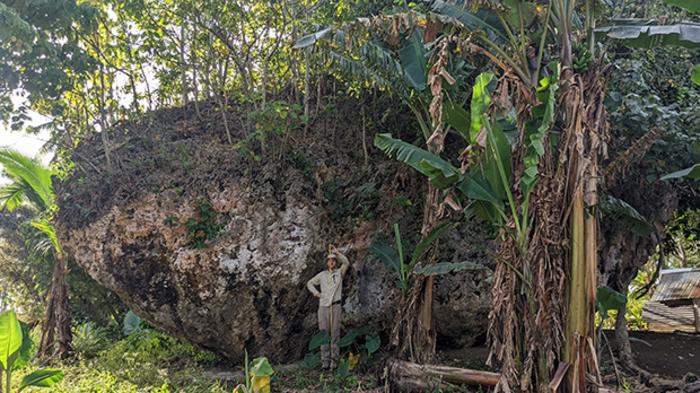

In a groundbreaking discovery that reshapes our understanding of coastal geology and tsunami dynamics, researchers have identified the world’s largest known cliff-top boulder located on the island of Tongatapu in Tonga. This colossal rock, known as the Maka Lahi boulder, weighs an estimated 1,200 tonnes and measures a staggering 14 by 12 by 6.7 meters. Its presence far inland and high above sea level challenges previous assumptions about the capabilities of tsunami waves in wave-rock transport and offers vital insights into the region’s geological history and future hazard risks.
The Maka Lahi boulder was discovered during a field survey conducted by a research team from The University of Queensland’s School of the Environment, led by PhD candidate Martin Köhler. Their work, which involved careful examination of the southern coastal cliffs of Tongatapu, tapped into evidence of past tsunamis imperceptible to casual observers. It was a fortuitous chance encounter with local farmers that directed the team to this extraordinary geological feature, situated over 200 meters inland from the coastline and perched on a cliff nearly 30 meters above current sea level.
This rock’s sheer size and location imply it was dislodged and transported by an exceptionally powerful tsunami event some 7,000 years ago, dating back to the early Holocene epoch. The Holocene, which started roughly 11,700 years ago, has witnessed significant climate and sea-level fluctuations, making the interpretation of natural phenomena such as tsunami deposits a crucial aspect of geoscientific research. Such a large cliff-top boulder carried inland provides formidable physical evidence of the magnitude and impact of prehistoric tsunami events in the Pacific region.
The research team employed advanced 3D modeling techniques to understand the precise dimensions of the Maka Lahi boulder and to estimate the forces necessary for its displacement. Their reconstruction traced the boulder’s probable origin point to a nearby coastal cliff rising over 30 meters above sea level. The numerical simulations conducted suggest that tsunami wave heights reaching approximately 50 meters with sustained wave energy lasting around 90 seconds would be necessary to uproot such a massive rock and transport it to its current resting place. This modeling challenges traditional estimates of tsunami wave dynamics by demonstrating the extraordinary power these natural disasters can exert.
Coastal geomorphologist Dr. Annie Lau, co-author of the study, emphasizes the geological and hazard significance of these findings. Tonga is a region of complex tectonic interactions, intersected by submarine volcanic chains like the Tofua Ridge and coupled with deep-sea trenches such as the Tonga Trench. This geodynamic environment makes the archipelago exceptionally vulnerable to tsunami generation, often triggered by seismic and volcanic events. The devastating 2022 tsunami, which claimed lives and caused widespread destruction, is a recent grim reminder of this threat. Understanding prehistoric tsunami occurrences, as revealed by geological evidence like the Maka Lahi boulder, is pivotal in enhancing risk assessment and mitigation strategies.
The discovery holds profound implications beyond Tonga’s shores. Wave-transported boulders have been considered indicators of tsunami intensity worldwide; however, few can compare to the magnitude and elevation of the Maka Lahi boulder. Its physical characteristics provide a unique natural laboratory for improving models of tsunami hydrodynamics, rock entrainment, and sediment transport under extreme wave conditions. Such advances contribute to refining predictive models essential for coastal hazard management globally, particularly for communities residing near vulnerable shorelines.
This study, published in the May 2025 issue of Marine Geology, represents a multidisciplinary effort integrating observational geomorphology with computational fluid dynamics. By quantifying the parameters required to move such a massive boulder, researchers can calibrate numerical tsunami models with greater accuracy and validate theoretical predictions against tangible real-world evidence. These insights are critical in reconstructing paleo-tsunami events that remain otherwise undocumented, expanding our geological archives.
Furthermore, the persistence of the Maka Lahi boulder in its current position over thousands of years exemplifies the stability of certain geological deposits amidst tropical environmental conditions, including dense vegetation growth surrounding the site. This stability allows scientists to reliably date the event and associate it with known climatic and tectonic phases during the Holocene. As such, the findings enrich our understanding of the frequency and scale of ancient tsunami events in the Pacific and their interaction with coastal topography.
The interdisciplinary nature of this research bridges the gap between geology, oceanography, and disaster risk science. It challenges previous models of rock transport by tsunami waves that underestimated the energy required or overlooked the potential for such large-scale inland displacement. By reshaping these paradigms, the discovery encourages a reassessment of tsunami hazard potential in island nations and coastal zones vulnerable to similar geological forces.
Future research inspired by this discovery will likely explore comparable records in other regions prone to large wave events, with an emphasis on identifying massive boulders displaced by tsunamis. Such investigations can help to forecast tsunami impact zones and improve early warning systems by providing empirical constraints on wave heights and run-up distances in complex coastal settings. Additionally, it underscores the importance of integrating local knowledge and field observations to uncover hidden geological phenomena that may otherwise elude technological detection.
In summary, the identification and analysis of the Maka Lahi boulder reveal the extraordinary capacity of past tsunamis to move massive geological objects far inland and high above sea level. The interdisciplinary approach, combining precise 3D mapping with numerical simulations, sets a new benchmark for tsunami research and coastal hazard assessment. This paradigm-shifting study not only enriches the geological history of Tonga but also resonates globally as nations seek to understand and mitigate their natural disaster risks in an era of climatic uncertainty and rising sea levels.
—
Subject of Research: Not applicable
Article Title: Discovery of the world’s largest cliff-top boulder: Initial insights and numerical simulation of its transport on a 30–40 m high cliff on Tongatapu (Tonga)
News Publication Date: 14-May-2025
Web References: http://dx.doi.org/10.1016/j.margeo.2025.107567
References: Köhler, M., Lau, A., et al. (2025). Discovery of the world’s largest cliff-top boulder: Initial insights and numerical simulation of its transport on a 30–40 m high cliff on Tongatapu (Tonga). Marine Geology.
Image Credits: Martin Köhler, The University of Queensland
Keywords
Tsunami, Cliff-top Boulder, Maka Lahi Boulder, Tonga, Wave Transport, Coastal Geomorphology, Numerical Modeling, Paleotsunami, Holocene, Marine Geology, Coastal Hazards, Geodynamics
Tags: Boulder geology and transportCliff-top boulder significanceCoastal erosion and sediment transportCoastal geology studiesGeological implications of tsunamisHistorical tsunami eventsMaka Lahi boulder discoveryPacific island geological historyTsunami dynamics researchTsunami evidence in TongaTsunami hazard risk assessmentUniversity of Queensland research


