Harnessing Machine Learning to Unravel the Mysteries of Siberia’s Land Cover
In the remote and expansive regions of Siberia, researchers have embarked on a groundbreaking initiative to develop a high-precision land cover map that significantly enhances our understanding of this crucial geographical area. Siberia, known for its vast forests, wetlands, and permafrost regions, plays an indispensable role in the global carbon cycle. With the accelerating impacts of climate change, the consequences of shifting vegetative patterns and thawing permafrost in this northern territory have become increasingly concerning. Thus, the classification and analysis of land cover in Siberia are not only important for ecological research but are essential for making informed predictions about future climate dynamics.
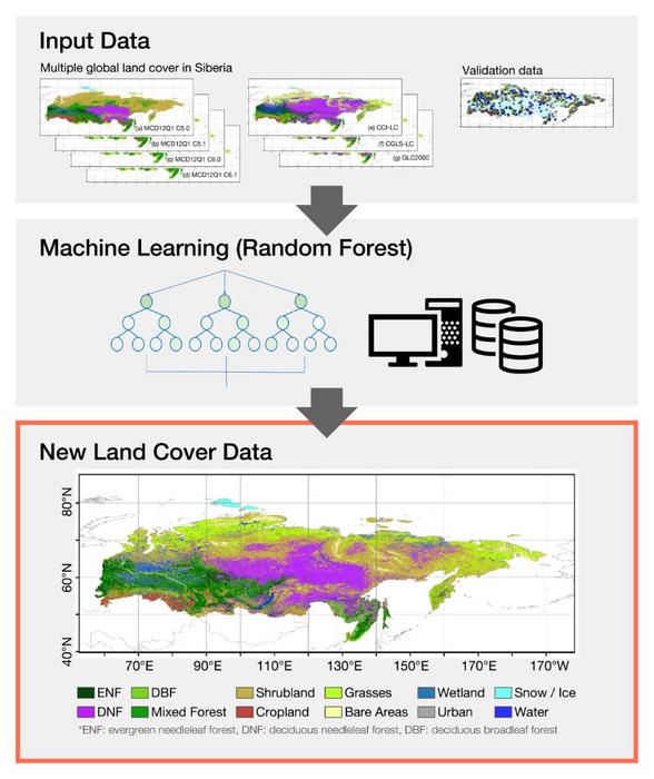
The study, led by Professor Kazuhito Ichii from Chiba University’s Center for Environmental Remote Sensing in Japan, marks a notable advancement in climatic sciences. The researchers capitalized on advanced machine learning techniques, specifically utilizing a random forest classifier, to synthesize multiple global land cover datasets. The unrivaled accuracy of 85.04% achieved in this study addresses significant discrepancies found in existing datasets, ultimately promising better reliability for climate models. Such an undertaking not only responds to the urgent need for accurate land classifications in poorly documented areas but also opens pathways for further explorations into ecological dynamics in Siberia.
As the researchers delved into the diverse array of global datasets, they identified substantial inconsistencies that undermined previous studies’ findings. Feedback from climate scientists indicated a surprising lack of coherence even in widely referenced datasets. This motivated the team led by Ichii to generate a more robust, cohesive dataset that would serve as a cornerstone for future research in climate models and ecological assessments. The integration of these advanced machine learning methods into environmental science not only exemplifies a practical application of technology in academia but also demonstrates the potential for significant breakthroughs in understanding complex systems like those found in Siberia.
Researcher Munseon Beak articulated the intent behind the study, suggesting that a concentrated focus on refining land cover classifications would elevate data quality in regions that had been historically underrepresented. She emphasized the potential of this comprehensive mapping project to rectify earlier erroneous interpretations of land use and vegetation distribution, especially in high-latitude regions. Further, the researchers observed that previous datasets often misrepresented the extent of carbon reserves, which is critical for formulating effective environmental policies.
In a collaborative effort with Nagoya University, the data compilation and analysis process began by meticulously comparing a multitude of existing datasets. The researchers aimed to discern patterns among the disparate datasets that could define land cover in Siberia more precisely. This comprehensive mapping initiative yielded clearer representations of forested areas, wetlands, and permafrost, which are vital ecosystems undergoing drastic transformations due to climate change and human activity. The improved insights gained from this study will not only aid in assessing current carbon flux but also facilitate more accurate predictions for future ecosystem changes.
The study holds profound implications for both academic researchers and policymakers alike. Climate change has led to observable shifts in Siberia’s landscape, including the northward migration of the Taiga and altered carbon dynamics. The enriched land cover dataset produced by Ichii and his team becomes a vital tool for scientists striving to monitor these transformations. It is through this enhanced understanding that researchers can develop strategies to manage and mitigate the adverse effects of climate phenomena impacting this fragile region.
As the research processes unfold, the study identifies critical factors that influence vegetation distribution. One significant finding noted by Professor Tetsuya Hiyama pertains to the role of precipitation in determining vegetation patterns, particularly in warmer summer conditions. As such, comprehending these climatic interactions may provide invaluable insights into broader environmental trends that transcend Siberia’s borders, giving rise to discussions on global climatic implications.
In addition to its academic contributions, the study serves a practical purpose for policy formulation. By delivering a more accurate assessment of land cover, the findings can assist in developing sustainable land management practices, which are increasingly necessary as the threats posed by climate change escalate. With Siberia’s unique ecosystems under threat, understanding the intricacies of their interactions can inform conservation efforts and disaster responses in the face of atmospheric shifts.
Moreover, the rich carbon reservoirs located in Siberia necessitate detailed assessments for evaluating greenhouse gas emissions and carbon sequestration processes. The new data will empower climate scientists to engage in carbon cycle evaluations, yielding insights that are critical for developing effective global climate strategies. The research exemplifies how technological advancements in data analysis can bolster our understanding of environmental patterns, thus underpinning future studies.
Professor Kazuhito Ichii’s commitment to research has long focused on terrestrial biosphere monitoring and modeling. With over 90 publications under his belt, he has pioneered various approaches to Earth system science. His extensive experience and innovative methodologies contribute significantly to the ongoing discourse surrounding climate change and ecological resilience. Ichii’s dedication to addressing the pressing issues in terrestrial studies conveys the importance of collaborative research efforts in driving the scientific community forward.
The outcomes of this research not only enrich the scientific database for Siberia but also establish a precedent for future studies concentrating on climate and land use. As climate conditions continue to evolve, such comprehensive datasets will be essential for developing responsive climate strategies and preserving Earth’s climatic equilibrium.
In summary, the multi-faceted approach utilized in the refined land cover mapping of Siberia serves as a template for integrating machine learning techniques into environmental science. By thoroughly assessing and reclassifying land cover, the research team has expanded the horizon for climate science, providing an invaluable resource for researchers, policymakers, and environmentalists alike. The rich findings are anticipated to resonate within the scientific community, potentially influencing future dialogues surrounding ecological preservation and climate dynamics.
Subject of Research:
Article Title:
News Publication Date:
Web References:
References:
Image Credits:
Keywords
Tags: advancements in climatic sciencesclimate change impacts on vegetationclimate models reliabilityecological research in Siberiaenvironmental remote sensing advancementsglobal carbon cycle dynamicshigh-precision land cover datamachine learning in climate sciencepermafrost thawing effectsrandom forest classifier applicationsSiberia land cover mappingsustainable land management strategies
