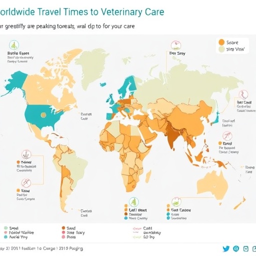
In a groundbreaking endeavor that bridges public health, animal welfare, and global infrastructure, researchers Criscuolo, Wang, and Van Boeckel have unveiled a comprehensive global map detailing travel times required to access veterinary services. Published in Nature Communications, this study marks a seminal advancement in understanding geographic disparities and accessibility barriers faced by countless populations reliant on veterinary care. The implications stretch beyond simple animal health, touching on zoonotic disease control, food security, and sustainable development goals worldwide.
Access to veterinary care is a fundamental yet often overlooked component of both human and animal health systems. Livestock, companion animals, and wildlife depend on veterinarians to manage illness, monitor zoonoses, and maintain ecological balance. Historically, data quantifying how far communities must travel to reach such essential services has been fragmented or region-specific. By harnessing high-resolution travel time modeling combined with an unprecedented aggregation of global infrastructural and demographic data, this new research fills a critical knowledge void.
The core methodological innovation of this study hinges on sophisticated geospatial analysis that integrates strata of road networks, transport modalities, and environmental barriers with the precise locations of veterinary service providers worldwide. Unlike previous studies that relied on simple proximity or population density measures, the authors employed a multi-modal routing algorithm that simulates real-world travel conditions under various terrains and infrastructural scenarios. This yields a finely granulated travel time surface, offering detailed insights into spatial accessibility dynamics on a truly global scale.
.adsslot_SaICRf6oYM{ width:728px !important; height:90px !important; }
@media (max-width:1199px) { .adsslot_SaICRf6oYM{ width:468px !important; height:60px !important; } }
@media (max-width:767px) { .adsslot_SaICRf6oYM{ width:320px !important; height:50px !important; } }
ADVERTISEMENT
Their analysis reveals stark disparities that correlate strongly with economic status, urbanization, and regional infrastructural investment. While developed regions display predictable patterns of short veterinary access times—often under 30 minutes—many rural communities, especially in low-income countries, face travel durations exceeding several hours. This extended travel time has severe repercussions: delayed treatment, increased animal morbidity and mortality, diminished productivity in agricultural sectors, and heightened risk of zoonotic disease transmission.
The researchers also highlight that travel time is a more meaningful metric than mere distance, as it accounts for transportation modes availability and road quality—factors critical in regions where paved roads are scarce and vehicles may be limited. For example, in parts of Sub-Saharan Africa and South Asia, travel time maps illustrate how seasonal weather conditions exacerbate inaccessibility by rendering roads impassable, a nuance that static distance maps fail to capture.
Beyond identifying geographic inequities, the study explores potential policy interventions. By overlaying their travel time maps with data on livestock density and disease prevalence, the authors pinpoint high-impact zones where infrastructure development or veterinary workforce deployment could yield outsized benefits. This kind of targeted resource allocation is essential to optimizing public health initiatives, particularly in regions vulnerable to emerging zoonotic outbreaks.
Importantly, the mapping tool developed by Criscuolo and colleagues is designed to be interactive and scalable. The open-access platform allows policymakers, researchers, and international organizations to dynamically query veterinary accessibility in relation to diverse parameters such as animal populations, median income, and healthcare infrastructure. This interconnectivity fosters cross-sectoral collaboration and data-driven decision-making at local, national, and global levels.
The interdisciplinary nature of this research also embodies the One Health concept, recognizing the inextricable links between human health, animal wellbeing, and ecosystem integrity. By improving access to veterinary care, communities can better prevent and control diseases that jump species boundaries—mitigating risks before they escalate into pandemics with devastating global impacts.
The authors underscore the urgency of integrating veterinary access metrics into broader health system strengthening and economic development agendas. As climate change, urban expansion, and globalization intensify, vulnerabilities in veterinary service delivery risk compounding, particularly in marginalized communities. This global map acts as both a diagnostic tool and a strategic guide for preventing service deserts that threaten both animal and human populations.
Technically, the study’s model integrates satellite-derived land cover data, elevation models, and census statistics alongside veterinary facility registries. Travel speeds were parameterized by road type classifications and adjusted according to environmental modifiers like slope gradient and seasonal flooding risks. This multilayered approach reduces biases inherent in previous assessments that either over- or underestimated accessibility due to simplistic assumptions.
Validation of the model employed ground-truthing methodologies in diverse pilot regions, comparing predicted travel times with actual data collected through community surveys and GPS tracking. The high concordance between modeled and empirical data strengthens confidence in the map’s applicability for real-world planning and resource prioritization.
This research emerges at a critical juncture—where equitably distributed veterinary services are no longer an ancillary concern but a cornerstone of planetary health resilience. The global community’s collective ability to mitigate animal disease outbreaks, safeguard food systems, and protect endangered species hinges upon actionable intelligence mapping disparities like those exposed here.
Moreover, this study invites future research into temporal variations of veterinary accessibility, considering factors such as conflict zones, migration patterns, and evolving infrastructure projects. Time-sensitive data could amplify the precision of emergency response planning and disease surveillance strategies, especially in times of crisis.
In summation, the publication of a global travel time map to veterinary services represents a milestone in the nexus of geospatial science, veterinary epidemiology, and public health policy. By illuminating the physical barriers that hinder critical veterinary access worldwide, Criscuolo, Wang, and Van Boeckel provide an indispensable instrument for stakeholders committed to sustainable, equitable, and integrated health solutions. Their work exemplifies the transformative power of cutting-edge data analytics when aligned with pressing global challenges.
The study’s influence is poised to reverberate across disciplines—from veterinary medicine and agriculture to international development and disaster risk reduction—stimulating innovation and collaborative interventions. As the world grapples with complex health threats, ensuring that veterinarians are reachable becomes not just a local improvement but a planetary imperative.
Subject of Research: Global geographic accessibility to veterinary services measured through travel time modeling.
Article Title: A global map of travel time to access veterinarians.
Article References:
Criscuolo, N.G., Wang, Y. & Van Boeckel, T.P. A global map of travel time to access veterinarians.
Nat Commun 16, 5849 (2025). https://doi.org/10.1038/s41467-025-60102-y
Image Credits: AI Generated
Tags: companion animal healthcare disparitiesfood security and animal healthgeographic disparities in animal healthcaregeospatial analysis in health researchglobal infrastructure and animal welfareglobal veterinary care accesslivestock health and veterinary servicespublic health and veterinary medicinesustainable development goals and veterinary caretravel time analysis for veterinary servicesveterinary care accessibility barrierszoonotic disease management

