
Credit: American Chemical Society
Engineering researchers at The University of Texas at Austin have developed the most detailed and extensive local map of air pollution ever produced for an urban area, using specially equipped Google Street View cars to measure air quality on a block-by-block basis. This new hyper-local mobile approach to measuring air quality, which reveals that air pollution can vary dramatically even within a single city block, could address major air quality monitoring gaps worldwide.
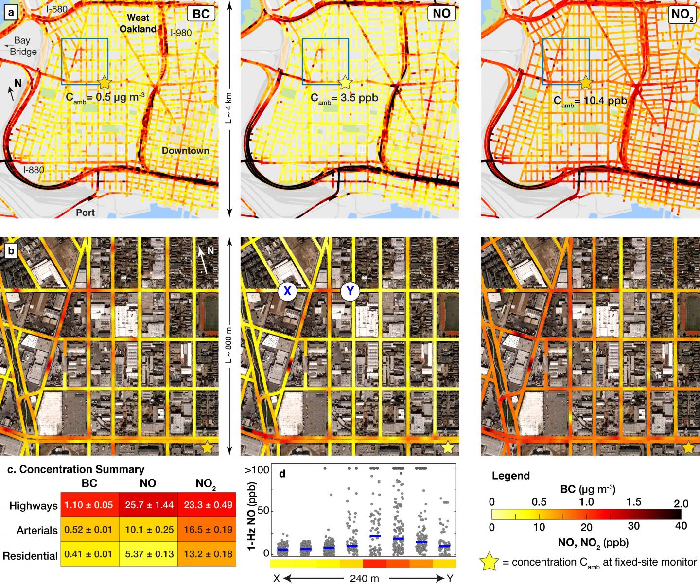
The research team was led by Cockrell School of Engineering assistant professor Joshua Apte in partnership with the Environmental Defense Fund (EDF), Google and Aclima, a California-based provider of environmental sensors. By integrating Aclima's sensor system into Google Street View cars, the team mapped air pollution in 78 square miles of Oakland, California, over an entire year, collecting one of the largest data sets of air pollution ever measured of single city streets. This new technique maps urban air pollution at 100,000 times greater spatial resolution than is possible with traditional government air quality monitors. Their approach and findings were published this week in the journal Environmental Science & Technology. The study included co-authors from the University of Washington, University of British Columbia, Utrecht University, Lawrence Berkeley National Laboratory, Aclima and EDF.
The team believes that their hyper-local mobile measurement system could be implemented in many cities throughout the world, providing detailed air quality information for citizens, families, local governments and scientists. The new technique could address major air quality monitoring gaps worldwide and has the potential to transform the way air pollution is monitored in urban areas as well as shed light on the health effects on city dwellers.
Air pollution is a major global risk factor for illness and death, and the air pollution that people are breathing can be, at times, far worse than what official air quality monitors report. Most large urban areas have only one air quality monitor for every 100 to 200 square miles. In comparison, the UT Austin team's mobile approach maps air pollution every 100 feet, or at about four to five locations along a single city block.
"Air pollution varies very finely in space, and we can't capture that variation with other existing measurement techniques," Apte said. "Using our approach and analysis techniques, we can now visualize air pollution with incredible detail. This kind of information could transform our understanding of the sources and impacts of air pollution."
In many locations, the team's Google cars measured air pollution levels that were several times higher than at Oakland's official monitors. In their analysis, the researchers also identified many recurring hotspots where pollution on a single block was consistently much higher than elsewhere in a neighborhood. These pollution hotspots included the port, busy intersections, restaurants, warehouses, industrial plants and vehicle dealerships.
"What surprised us is that there are consistently locations that can be as much as six times more polluted on one end of the block than on the other," said Kyle Messier, a UT Austin postdoctoral fellow and a co-author of the study. "Among other things, this demonstrates that people are getting disproportionate exposures of unhealthy air at some locations."
This project is the latest phase of a partnership between EDF and Google, who have been working together since 2012 to map and measure a growing list of health and environmental risks, including hidden leaks from local natural gas systems.
"Air pollution is largely an invisible threat, one that poses especially disproportionate risks in lower-income areas like West Oakland. This new method allows us to visualize the data so communities and policymakers can identify the sources of harmful pollution and take action to improve safety and health," said Steven Hamburg, EDF's chief scientist.
The study's approach was designed to be cost-effective and easily replicated. For instance, research partner Aclima designed pollution sensing systems that made it straightforward to collect high-quality air pollution data on moving vehicles day after day. Driving more than 14,000 miles, the Google cars collected 3 million measurements of nitric oxide, nitrogen dioxide and black carbon pollutants in Oakland, generating the largest urban air quality data set of its kind.
As the study's principal investigators, UT Austin's contributions included:
- Designing the data collection approach and directing where the cars drove on a daily basis.
- Developing data analysis algorithms to produce block-by-block maps of street-level air pollution from measurements made by passing Street View cars.
- Identifying neighborhood hotspots of air pollution.
- Determining how this approach could be efficiently scaled up to other urban areas.
In the future, Apte hopes to take this mobile air quality monitoring approach to other major cities to help formulate a hyper-local map of air pollution in the United States that could help people make more informed decisions.
"You could use this information when you're picking a school for your kids. Is there a school with a playground that might have better air quality because your kid has asthma?" Apte said. "This hyper-local information about consistent air quality can be really useful for people, especially those who are vulnerable because of age or health condition."
###
Funding for the study was provided by the Environmental Defense Fund.
Media Contact
Sandra Zaragoza
[email protected]
512-471-2129
@UTAustin
http://www.utexas.edu
############
Story Source: Materials provided by Scienmag


