A new study introduces the Hybrid Global Annual 1-km International Geosphere-Biosphere Programme (IGBP) Land Cover Maps for the period 2000-2020. This innovative dataset, free to access, marks a significant step forward in global land cover mapping, addressing longstanding issues of disagreement and incompatible classification systems among existing land cover products.
Credit: Journal of Remote Sensing
A new study introduces the Hybrid Global Annual 1-km International Geosphere-Biosphere Programme (IGBP) Land Cover Maps for the period 2000-2020. This innovative dataset, free to access, marks a significant step forward in global land cover mapping, addressing longstanding issues of disagreement and incompatible classification systems among existing land cover products.
Global land cover data, essential for environmental research, are plagued by inconsistencies across different datasets, complicating global change studies. The diversity in classification systems and methodologies challenges the creation of a unified, accurate land cover map. Addressing these discrepancies is crucial for effectively monitoring ecological transformations and supporting sustainable development, highlighting the urgent need for integrated and reliable land cover information.
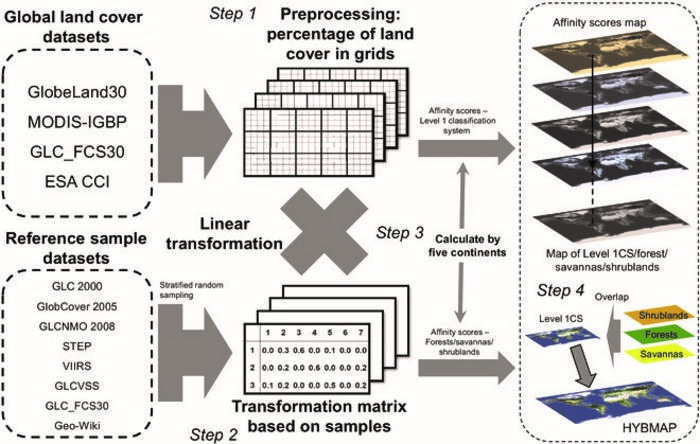
In March 2024, researchers from Peking University published a new study (DOI: 10.34133/remotesensing.0122) in the Journal of Remote Sensing. They integrated four major land cover products using a hierarchical International Geosphere-Biosphere Programme (IGBP) classification system, leading to the creation of a hybrid global annual land cover product (HYBMAP). This hybrid approach harmonizes disparate land cover datasets and offers improved resolution and accuracy.
This research intricately weaves together data from four major land cover datasets utilizing a refined IGBP classification system. By harnessing a global collection of reference samples for unprecedented accuracy, HYBMAP mitigates the longstanding issue of discrepancies among existing datasets, showcasing a remarkable reduction in disagreement by up to 20.1%. What sets HYBMAP apart is its dual focus on enhancing accuracy and resolution, achieving an overall accuracy of 75.5%, thereby outperforming the individual datasets it integrates. This meticulous synthesis not only harmonizes divergent classification systems but also encapsulates temporal changes, identifying trends such as the rapid expansion of built-up areas.
Zaichun Zhu, the corresponding author, emphasizes the importance of HYBMAP in global change research, stating, “HYBMAP’s integration of multiple data sources and its enhanced accuracy provide a more reliable foundation for studying global biogeochemical cycles and ecosystem services.”
HYBMAP offers a consistent and reliable global land cover time series, essential for environmental monitoring, policy-making, and climate change research. Its enhanced accuracy and resolution will improve our understanding of land use impact on global ecosystems and help in the development of sustainable land management strategies.
###
References
DOI
10.34133/remotesensing.0122
Original Source URL
https://spj.science.org/doi/10.34133/remotesensing.0122
Funding information
This work was supported by the National Natural Science Foundation of China (42271104), the Shenzhen Fundamental Research Program (GXWD20201231165807007-20200814213435001), the Shenzhen Science and Technology Program (JCYJ20220531093201004), and Shenzhen Science and Technology Program (KQTD20221101093604016).
About Journal of Remote Sensing
The Journal of Remote Sensing, an online-only Open Access journal published in association with AIR-CAS, promotes the theory, science, and technology of remote sensing, as well as interdisciplinary research within earth and information science.
Journal
Journal of Remote Sensing
DOI
10.34133/remotesensing.0122
Subject of Research
Not applicable
Article Title
Hybrid Global Annual 1-km IGBP Land Cover Maps for the Period 2000–2020
Article Publication Date
1-Mar-2024
COI Statement
The authors declare that they have no competing interests

