
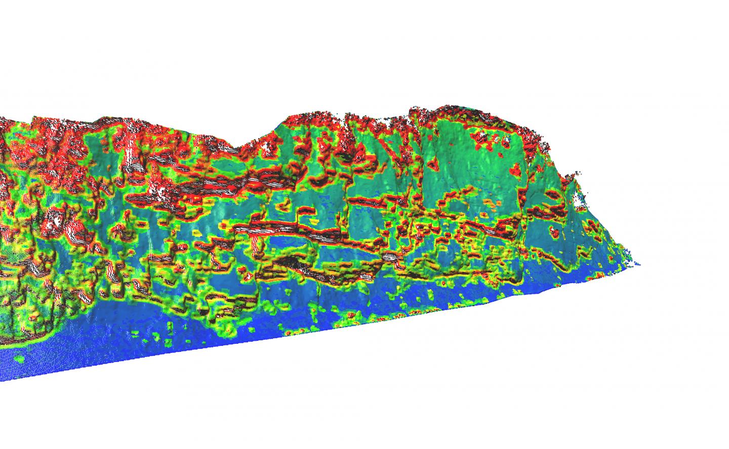
Credit: (Image by Matt O'Banion, courtesy of Oregon State University)
CORVALLIS, Ore. – Researchers in the Pacific Northwest have developed a new, automated technology to analyze the potential for rockfalls from cliffs onto roads and areas below, which should speed and improve this type of risk evaluation, help protect public safety and ultimately save money and lives.
Called a "rockfall activity index," the system is based on the powerful abilities of light detection and ranging, or LIDAR technology. It should expedite and add precision to what's now a somewhat subjective, time-consuming process to determine just how dangerous a cliff is to the people, vehicles, roads or structures below it.
This is a multi-million dollar global problem, experts say, of significant concern to transportation planners.
It's a particular concern in the Pacific Northwest with its many mountain ranges, heavy precipitation, erosion of steep cliffs and unstable slopes, and thousands of roads that thread their way through that terrain. The evaluation system now most widely used around the world, in fact, was developed by the Oregon Department of Transportation more than 25 years ago.
The new technology should improve on that approach, according to scientists who developed it from the University of Washington, Oregon State University and the University of Alaska Fairbanks. Findings on it were just published in Engineering Geology.
"Rockfalls are a huge road maintenance issue," said Michael Olsen, an associate professor of geomatics in the College of Engineering at Oregon State University, and co-author of the report.
"Pacific Northwest and Alaskan highways, in particular, are facing serious concerns for these hazards. A lot of our highways in mountainous regions were built in the 1950s and 60s, and the cliffs above them have been facing decades of erosion that in many places cause at least small rockfalls almost daily. At the same time traffic is getting heavier, along with increasing danger to the public and even people who monitor the problem."
The new approach could replace the need to personally analyze small portions of a cliff at a time, looking for cracks and hazards, with analysts sometimes even rappelling down it to assess risks. LIDAR analysis can map large areas in a short period, and allow data to be analyzed by a computer.
"Transportation agencies and infrastructure providers are increasingly seeking ways to improve the reliability and safety of their systems, while at the same time reducing costs," said Joe Wartman, associate professor of civil and environmental engineering at the University of Washington, and corresponding author of the study.
"As a low-cost, high-resolution landslide hazard assessment system, our rockfall activity index methodology makes a significant step toward improving both protection and efficiency."
The study, based on some examples in southern Alaska, showed the new system could evaluate rockfalls in ways that very closely matched the dangers actually experienced. It produces data on the "energy release" to be expected from a given cliff, per year, that can be used to identify the cliffs and roads at highest risk and prioritize available mitigation budgets to most cost-effectively protect public safety.
"This should improve and speed assessments, reduce the risks to people doing them, and hopefully identify the most serious problems before we have a catastrophic failure," Olsen said.
The technology is now complete and ready for use, researchers said, although they are continuing to develop its potential, possibly with the use of flying drones to expand the data that can be obtained.
Tens of millions of dollars are spent each year in the U.S. on rock slope maintenance and mitigation.
###
This research was supported by the Pacific Northwest Transportation Consortium, the National Science Foundation and the Alaska Department of Transportation and Public Facilities. Co-authors included Lisa Dunham, former civil and environmental engineering graduate student at the University of Washington; graduate assistant Matthew O'Banion at OSU; and Keith Cunningham, research assistant professor of remote sensing at the University of Alaska Fairbanks.
Media Contact
Michael Olsen
[email protected]
541-737-9327
@oregonstatenews
http://www.orst.edu
############
Story Source: Materials provided by Scienmag
