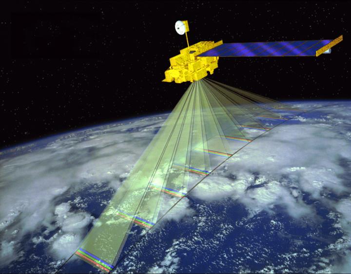

Credit: NASA
Using data from NASA satellites and airport visibility sensors, Veterans Affairs (VA) researchers and colleagues are extending an approach used to study air pollution in the U.S. They are developing methods to estimate exposures–from dust and sand storms and other sources — for U.S. troops who fought in Iraq and Afghanistan.
The work to date is reported in three related studies, two now online in the Journal of the Air and Waste Management Association and one pending publication.
The goal is to build reliable tools for epidemiologists trying to tease out the links between respiratory health and exposure to air pollution, especially in areas of the world where American troops are deployed but that lack air-quality monitoring networks like those in the U.S.
VA funded the research as a pilot to lay the groundwork for a larger study, under the auspices of VA's Cooperative Studies Program, to assess the lung health of 4,500 Iraq and Afghanistan veterans. The study, expected to be launched in 2017, is titled "Pulmonary Health and Deployment to Southwest Asia and Afghanistan."
The three preliminary studies involved researchers from VA, the U.S. Army, Harvard, and universities in Kuwait and Israel.
The lead experts in satellite imaging were Dr. Alexandra Chudnovsky in the Department of Geography and Human Environment, School of Geosciences, Tel Aviv University; and Dr. Petros Koutrakis in the Department of Environmental Health at the Harvard T.H. Chan School of Public Health. Chudnovsky is also currently a visiting scientist at the Chan School.
One of the newly published studies looked at how satellites can be used to estimate relative exposures to particulate matter–fine particles in the air that can harm the lungs over time. The focus was on PM2.5–particles smaller than 2.5 microns in diameter, which can lodge deep in the lungs. The team analyzed data for the years from 1997 to 2010. The work thus covers all of Operation Iraqi Freedom, which ran from 2003 to 2010. Between 2003 and 2011, more than 1.5 million American troops served in Iraq.
Satellites orbiting the earth routinely collect data on air quality. They do so by gauging how much light can travel through the atmosphere to reach on-board sensors. The resulting measurement, known as aerosol optical depth, may be used as a marker of air pollution.
"These satellites analyze the [light] energy that's deflected back up to the satellite," explains coauthor Dr. Eric Garshick, a physician with the VA Boston Healthcare System and Harvard Medical School. "Over the years, the analysis routines for these data have gotten more and more sophisticated. You can analyze data that is proportional to particle levels in the air, down to a one-square-kilometer level."
In the U.S., most air-quality data is gathered by monitoring stations on the ground. But in some areas of the world–including much of the Middle East–ground stations are rare, and satellites that circle the globe are one of the only sources of data on pollution.
Garshick and his colleagues are among the first to use satellite data to learn about the air conditions in which U.S. troops operated. A 2002 study by a VA, Army, and University of Iowa team used satellite and other data in a study of possible links between Kuwait oil fires and lung health in Gulf War Veterans.
The two other preliminary studies funded by VA took further steps toward developing ways to reliably estimate pollution in the absence of ground monitoring stations.
In one study, the researchers used visibility and humidity readings from U.S. air bases in Iraq, Afghanistan, and other countries in the region. They paired more than 600 daily readings with actual air samples that had been collected in Kuwait during the same days, as a way of calibrating the visibility data. The upshot, they write is that "[visibility] and relative humidity measurements are useful predictors of chronic PM2.5 exposure in Kuwait. Given the geographic proximity between Kuwait and its neighboring countries … this study provides for a possible means of predicting chronic PM2.5 in the greater Southwest Asia and Afghanistan region."
In the other study, the researchers used more than 1,800 paired readings — from U.S. air bases in Iraq and from satellites — to build a calibration model. Using this method, and relying on prior work they had done on the link between visibility and particulate matter in the air, the team estimated ground-level PM2.5 over an area of about 17,000 square kilometers during 2006 and 2007.
Garshick explains why the team used airport visibility data:
"The question was, what can you use that's in the area to calibrate satellite imaging that reflects air pollution? And it turns out that airport visibility is the earliest known measure of air pollution. Before anyone even used to measure air pollution, they'd look up at the sky and flash a visible beam, and you could come up with how far that went. And that's proportional to air pollution [because particles block some of the light]. The very early air pollution studies were based on these types of visibility measurements."
Today, most airports around the world have sophisticated units that send out a laser beam to a detector a few meters away. They can tell how much light is transmitted and how much is absorbed in the fog, or by particles in the air.
The data are stored long-term, meaning airports can remain a reliable resource for estimating air pollution levels even years later. And given the prevalence of air bases in areas where U.S. forces operate, and the frequency with which readings are taken, the researchers believe the data can be harnessed to great advantage by VA and Defense studies on respiratory health.
"We have airport visibility readings from the [U.S.] Air Force all over Afghanistan and Iraq, as well as other countries in the region," notes Garshick. "They exist anywhere there's an American base–anywhere you want to land any type of aircraft, even a small air base servicing some forward area. In order for a helicopter to land, you'd have to have a visibility reading. The Air Force records every hour. They have portable visibility units they put out–similar to portable weather stations."
Garshick emphasizes that his group aimed only to build methods to determine past exposures to particles in the air. The health effects of such exposures continue to be studied.
"This is only about exposure, not outcomes," he says Garshick. He acknowledges, though, that in general, long-term PM2.5 exposure is known to harm the lungs.
One of Garshick's main areas of study in recent years has been the health effects of chronic exposure to diesel exhaust.
For the satellite work, among other sources, the research used data from the MODIS instrument aboard NASA's Terra satellite. The spacecraft, the size of a small school bus, has been circling the earth 16 times a day, 438 miles high, since December 1999. The researchers also used data from the SeaWiFS sensor on NASA's SeaStar satellite. That spacecraft has been orbiting earth since 1997, although the SeaWiFS degraded and stopped collecting data in 2010. The team also used data from the Ozone Monitoring Instrument aboard the Aura satellite, launched in 2004.
###
For more information about VA research, visit http://www.research.va.gov.
Media Contact
Pallas A. Wahl
[email protected]
857-203-5879
http://www.va.gov/
############
Story Source: Materials provided by Scienmag
