Credit: Credits: NASA/NOAA GOES Project
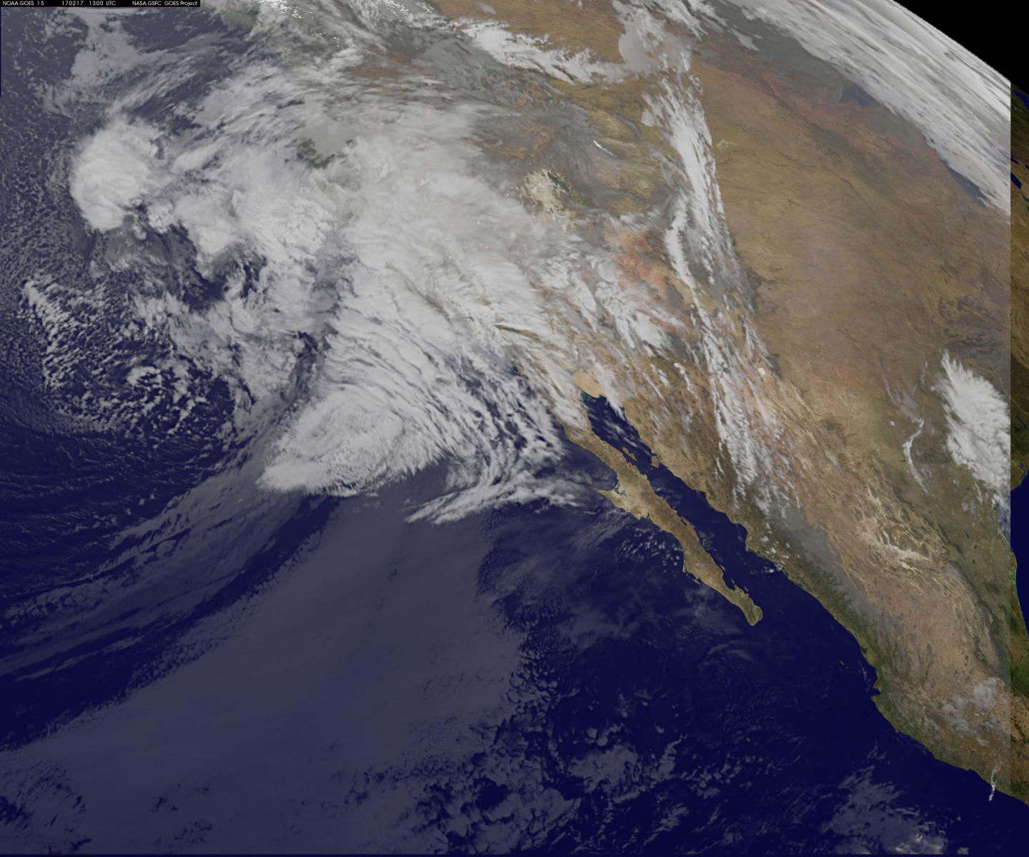
Satellite imagery captured the beginning of a chain of Eastern Pacific Ocean storms forecast to affect the U.S. West Coast. A close-up satellite view show from Feb. 17 shows a large storm system affecting southern California, while a wider satellite view revealed a second storm system in the Central Pacific Ocean headed toward the east.
An almost continuous onshore flow is expected to bring storms to California and portions of the Pacific Northwest in a very active, wet pattern over the next couple of days, according to the National Weather Service.
NOAA's GOES-West satellite keeps a constant eye on the western U.S. and the Eastern Pacific Ocean. NOAA manages the Geostationary Operational Environmental Satellite or GOES series of satellites, while NASA/NOAA's GOES Project at NASA's Goddard Space Flight Center in Greenbelt, Maryland uses that data to create images and animations. On Feb. 17 at 1300 UTC (8 a.m. EST) an infrared image showed the large storm system that is expected to bring heavy rain to southern California. Infrared imagery measures temperature and is used to detect clouds at night.
NASA/NOAA's GOES Project also provided a wider view from GOES-West that showed the Eastern and Central Pacific Ocean and two systems. Behind the system currently impacting southern California is another low pressure system to the west, in the Central Pacific Ocean. That system is also headed toward the Pacific coast.
On Feb. 17, the National Weather Service (NWS) Weather Prediction Center noted "Another series of powerful Pacific storms will bring heavy rain and strong winds to the west coast. Saturated soils from previous rains could lead to additional floods, flash floods, and mudslides along the west coast. However, the most intense rainfall is forecast to inundate Southern California Friday into Saturday [Feb. 18]."
Rain and mountain snow is forecast for much of the western U.S. as a deep upper-level low pressure area and associated surface cold front pushes inland, according to forecasters at NWS. That means heavy rainfall for coastal areas and nearby mountains. Some areas are forecast to see as much as 4 inches of rainfall by the morning of Saturday, Feb. 18.
On Feb. 17 the NWS in Los Angeles, California issued several warnings. There is a Flash Flood Watch in effect from 7 a.m. PST until Feb. 18 at 11 a.m. PST. The NWS forecast calls for "Periods of heavy rain with rainfall rates around 1 inch per hour at times. Rainfall totals through Saturday morning are expected to average 3 to 6 inches in coastal and valley areas and 5 to 10 inches in favored foothill and mountain locations. The highest rainfall totals are expected along and below south facing slopes from the Santa Ynez Range eastward through the San Gabriel Mountains."
There is also a High Surf Advisory in effect until Feb. 19, 10 p.m. PST, and a Wind Advisory in effect from Feb. 17 at 7 a.m. PST until Feb. 17 at 7 p.m. PST.
There is a danger of rapid runoff in fire scarred areas, which can result in flash flooding, mudslides or debris flows. Rivers and streams may also rise quickly in response to the significant rainfall. The NWS also noted that warmer temperatures could speed up snow melt across the region.
###
Media Contact
Rob Gutro
[email protected]
@NASAGoddard
http://www.nasa.gov/goddard
############
Story Source: Materials provided by Scienmag


