
Researchers from Politecnico di Milano and the National Technical University of Athens are at the forefront of a significant advancement in the field of remote sensing imagery analysis. They have introduced a novel segmentation pipeline designed to automatically identify and label features in aerial and satellite imagery more efficiently. This work comes at a time when the sheer volume of aerial and satellite data continues to swell globally, yet the challenge of accurately pinpointing objects such as trees, cars, and rooftops remains a formidable task.
Traditional methods of image analysis often struggle with the growing diversity and complexity of features found in new aerial and satellite images. General-purpose artificial intelligence models, while powerful, frequently falter when faced with unfamiliar objects that lack specific prior training. This limitation can lead to an increased computational burden and lower accuracy in identifying targeted features. The researchers address these challenges through a novel methodological approach that enhances both the efficacy and efficiency of the analysis process.
The key innovation in this new pipeline is the implementation of a sliding window hyper inference approach. By segmenting large images into smaller, manageable patches, the researchers are able to apply complex AI models more effectively. This method not only reduces the workload on computational resources but also increases detection accuracy as the models can focus on smaller sections of the image. Each of these smaller patches is analyzed individually, ensuring that even the most intricate details are captured.
In a groundbreaking two-step methodology, this pipeline incorporates advanced open-source AI models, specifically the Segment Anything Model (SAM) and Grounding DINO. The initial phase of the process is intentionally designed to over-detect objects within the imagery. This over-detection is crucial, as it ensures that no relevant detail is overlooked during the segmentation process. By applying AI detection models to the numerous smaller patches created from the larger aerial images, researchers can maximize their chances of capturing all necessary features.
Following this initial over-detection phase, the method transitions to a refinement step. The pipeline utilizes statistical and data-driven techniques to filter out irrelevant bounding boxes. These could be excessively large boxes or those poorly positioned within the image, which do not accurately represent the true features. This system of refinement ensures that only the most credible and high-quality bounding boxes are retained for further analysis. The final step is where SAM is applied to produce precise segmentation masks that can effectively delineate the identified features.
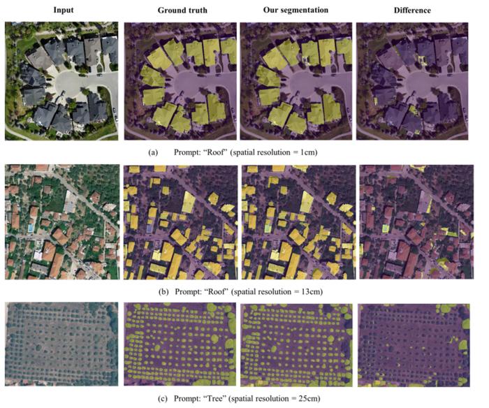
A crucial aspect of this new pipeline is its zero-shot inference capability. This means that the AI models are utilized in their original form, without any additional fine-tuning or retraining on external datasets. This ability to operate in a zero-shot manner significantly enhances the usability of the pipeline, allowing the researchers to achieve up to 99% accuracy for segmentation in aerial images with a spatial resolution of less than one meter. The potential for high accuracy without extensive model training presents a promising development in practical applications of AI in geosciences.
The process, developed by Mohanad Diab and his colleagues, reflects an intelligent integration of cutting-edge technology with practical requirements. The use of large-scale AI models allows for robust analyses suitable for various real-world applications, from environmental monitoring to urban planning. As noted by Professor Maria Antonia Brovelli, the corresponding author of the study, this strategic approach can significantly reduce the computational demands associated with processing large datasets while improving the overall quality of results.
Additionally, the implications of this new pipeline extend beyond just the realm of academia. The methods employed could pave the way for automation in various sectors that rely on remote sensing technology. The accessibility and efficiency provided by the new system are poised to transform how organizations conduct imagery analysis, which could lead to increased adoption of aerial data for planning environmental surveys and urban initiatives.
As the research continues to evolve, the potential applications of this pipeline are vast. The ability to efficiently analyze large volumes of imagery can facilitate better decision-making in agriculture, forestry, disaster response, and urban development, ultimately contributing to enhanced sustainability efforts. As cities grow and environmental challenges mount, advancements like these play a crucial role in integrating technology with strategic planning.
Moreover, the collaborative efforts between Politecnico di Milano and the National Technical University of Athens exemplify how interdisciplinary approaches can fuel innovation. By combining expertise in AI, data science, and geosciences, the researchers have developed a solution that harnesses the full potential of current technologies while addressing pressing issues encountered in the field. Their work embodies the spirit of using cutting-edge research not only for academic purposes but also for solving real-world problems.
In summary, the innovative segmentation pipeline developed by these researchers stands as a testament to the power of intelligent engineering and analytic capabilities in enhancing how we approach remote sensing imagery. As the technology becomes more refined and accessible, the possibilities for its application in various fields are bound to expand, fostering a new era of automated analysis in remote sensing and beyond. The future of this research promises to unveil further advancements in AI and data processing that will continue to reshape our understanding and management of geographical data.
Subject of Research:
Article Title:
News Publication Date:
Web References:
References:
Image Credits:
Keywords
Tags: aerial imagery analysisautomated image segmentation techniquescomputational efficiency in image processingefficient object labeling methodsenhancing accuracy in remote sensinghyper inference approach in AIimage analysis challengesinnovative segmentation pipelineovercoming AI training limitationsremote sensing advancementssatellite imagery feature identificationzero-shot AI applications


