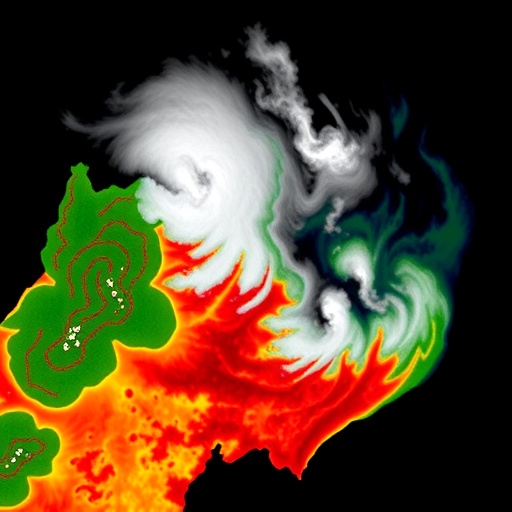
In the rapidly evolving field of Earth observation, the accurate mapping of forest burned areas (FBAs) has emerged as a critical challenge. The increasing frequency and intensity of wildfires worldwide underscore the necessity for precise, efficient, and scalable detection methodologies that can operate effectively despite common obstacles such as cloud cover in optical satellite data. A groundbreaking study published in the prestigious journal Big Earth Data introduces a novel deep learning architecture designed to revolutionize FBA detection by seamlessly integrating data from multiple satellite sensors. This pioneering approach, dubbed CA-MTransU-Net, stands at the forefront of remote sensing research, leveraging advanced attention mechanisms and multimodal data fusion to overcome longstanding limitations in the field.
Traditional methods for detecting burned forest areas using optical imagery have repeatedly stumbled against the pervasive problem of cloud contamination. Clouds obscure critical spectral information, rendering many optical satellite-based burn mapping algorithms less reliable in regions with frequent cloud cover. Previous attempts to mitigate this challenge often involve discarding cloudy images or resorting to less informative but cloud-penetrating radar data separately, limiting the granularity and efficacy of fire damage assessments. CA-MTransU-Net confronts this issue head-on by innovatively combining Sentinel-1 Synthetic Aperture Radar (SAR) data, known for its cloud penetration and all-weather capabilities, with Sentinel-2 optical imagery, which provides rich spectral information but is prone to cloud interference.
At the heart of CA-MTransU-Net lies a sophisticated dynamic cloud-weighting mechanism that intelligently adjusts the reliance on optical data according to cloud probability maps derived from the imagery itself. This adaptive weighting ensures that the model dynamically emphasizes the more reliable SAR inputs in cloud-affected regions, while still capitalizing on detailed spectral features from the optical data when clouds are absent or minimal. This nuanced integration vastly improves the robustness and accuracy of burned area detection, particularly in heterogeneous and cloud-prone landscapes where traditional single-modality approaches falter.
The architecture employs a cutting-edge Compact Linear Attention Mechanism (CLAM), a transformative innovation that addresses the prohibitive computational costs traditionally associated with transformer models in image segmentation tasks. Conventional attention mechanisms, integral for capturing long-range spatial dependencies, typically demand high memory and processing power, limiting their practical deployment. CLAM, however, utilizes a more efficient linearized attention approach that preserves the global context essential for accurate segmentation while significantly reducing computational overhead. This innovation allows CA-MTransU-Net to achieve superior inference speeds without compromising model performance, a substantial step forward for operational remote sensing applications.
Moreover, the inclusion of a Mixture-of-Experts (MoE) framework within the model architecture further enhances its capability to capture diverse and complex feature representations. By dynamically routing input data through multiple specialized subnetworks, or “experts,” the MoE design efficiently manages computational resources while enabling the integration of diverse data sources and spatial information. This modular design mirrors human cognitive processes and substantially elevates model generalizability across varied environmental conditions and fire scenarios.
Experimental evaluation of CA-MTransU-Net on benchmark datasets confirms its exceptional performance, setting a new standard in FBA mapping. The model achieved a mean Intersection-over-Union (mIoU) score of 87.00%, surpassing a range of well-established segmentation architectures such as U-Net, SegFormer, DeepLabv3+, and even transformer-based models like TransU-Net. This marked improvement—an average gain of over 6% compared to benchmark methods—illustrates the transformative potential of the cloud-aware, multimodal fusion approach. Notably, CA-MTransU-Net also demonstrated faster inference speeds, with milliseconds per image substantially lower than those of comparable transformer-based models, facilitating near real-time applications.
Despite these breakthroughs, the research acknowledges certain limitations inherent in the current model. The advanced attention and mixture-of-experts mechanisms, while computationally efficient relative to traditional transformers, still incur higher peak memory usage compared to simpler convolutional neural network architectures. This factor could constrain deployment in resource-restricted environments, such as onboard satellite processing units or mobile field devices. Additionally, similar to other automated segmentation models, CA-MTransU-Net occasionally misclassifies water bodies as burned areas, a challenge that warrants further refinement in post-processing algorithms or additional sensor integration.
The development of CA-MTransU-Net represents a significant leap forward in the integration of multimodal satellite data for environmental monitoring. Its cloud-aware design pragmatically addresses one of the most stubborn obstacles in remote sensing, enabling a more accurate and scalable mapping of fire-affected forests that can support disaster response and ecosystem restoration efforts worldwide. As wildfire events continue to threaten communities and biodiversity, such advanced tools provide invaluable insights for policymakers and conservationists aiming to mitigate harm and promote resilience.
An important contextual element of this research is its foundation on the synergistic use of Sentinel-1 and Sentinel-2 data platforms. Sentinel-1’s radar imaging offers consistent all-weather monitoring capabilities, penetrating clouds, rain, and smoke, while Sentinel-2’s multispectral optical sensors contribute rich spectral detail essential for precise vegetation and burn severity characterization. CA-MTransU-Net’s joint exploitation of these complementary datasets represents a paradigm shift toward data fusion strategies that can capitalize on the strengths of heterogeneous sensors.
This sophisticated fusion is orchestrated through a novel stacking technique whereby the input data cube comprises 24 spectral bands assembled from primary inputs, derived spectral indices, and auxiliary cloud probability maps. This layered data construction enriches feature representation and maximizes the utility of available observations. It exemplifies a methodological innovation that could inspire future remote sensing frameworks to embrace increasingly complex and informative data architectures without sacrificing computational tractability.
The broader implications of this research extend beyond forest fire monitoring. The model’s capacity to dynamically weigh sensor inputs based on cloud conditions and its efficient attention mechanism make it a promising candidate for a variety of Earth observation tasks hindered by atmospheric interference and large data volumes. Potential applications include flood mapping, agricultural monitoring, urban development tracking, and other environmental phenomena requiring resilient and high-fidelity image segmentation.
Published in Big Earth Data, a leading interdisciplinary platform dedicated to pioneering research in Earth system big data interpretation, CA-MTransU-Net exemplifies the profound impact of merging advanced artificial intelligence techniques with remote sensing data. The journal’s emphasis on open access and the promotion of cutting-edge analytical methods aligns perfectly with the goals of fostering global solutions for environmental stewardship and disaster risk reduction.
The authors of this innovation, led by Sahand Tahermanesh and colleagues, emphasize the importance of balancing accuracy with model efficiency, addressing both scientific challenges and practical constraints. Their work not only advances the theoretical frontier of deep learning in remote sensing but also offers tangible benefits for operational wildfire management, thus bridging the gap between research and real-world impact.
With wildfires poised to shape ecological and social landscapes in the coming years, models like CA-MTransU-Net provide powerful tools for rapid and reliable assessment, essential for directing emergency responses, managing post-fire landscapes, and monitoring recovery processes. As satellite technology and machine learning algorithms continue to co-evolve, integrated solutions such as this will be instrumental in safeguarding forests, biodiversity, and human livelihoods against the ravages of fire.
Subject of Research:
Not explicitly specified beyond computational simulation/modeling for forest burned area mapping using remote sensing data.
Article Title:
CA-MTransUNet: Cloud-Aware Mixture-of-Experts Linear Transformer U-Net for forest burned area (FBA) mapping using Sentinel-1 and Sentinel-2 images
News Publication Date:
9-Jan-2026
Web References:
DOI link to article
References:
Tahermanesh, S., Jamali, A., Moghimi, A., Mohsenifar, A., Khankeshizadeh, E., & Mohammadzadeh, A. (2026). CA-MTransUNet: Cloud-Aware Mixture-of-Experts Linear Transformer U-Net for forest burned area (FBA) mapping using Sentinel-1 and Sentinel-2 images. Big Earth Data, 1–30.
Image Credits:
Big Earth Data
Keywords
Deep learning; burned area mapping; TransU-Net; remote sensing; multi-sensor satellite imagery; Forest burned area detection; Cloud-aware modeling; Transformer; Attention mechanism; Synthetic Aperture Radar; Sentinel-1; Sentinel-2; Mixture-of-Experts
Tags: advanced forest fire monitoring techniquesattention mechanisms in transformer modelsCA-MTransU-Net architecturecloud-aware deep learning modelforest burned area mappingmultimodal data fusion in earth observationovercoming cloud cover challengesremote sensing for environmental disastersscalable wildfire damage assessmentSentinel-1 SAR data integrationSentinel-2 optical satellite imagerywildfire detection using remote sensing


