• HOME
  • NEWS
  • EXPLORE
    • CAREER
      • Companies
      • Jobs
    • EVENTS
    • iGEM
      • News
      • Team
    • PHOTOS
    • VIDEO
    • WIKI
  • BLOG
  • COMMUNITY
    • FACEBOOK
    • INSTAGRAM
    • TWITTER
Thursday, November 13, 2025
BIOENGINEER.ORG
No Result
View All Result
  • Login
  • HOME
  • NEWS
  • EXPLORE
    • CAREER
      • Companies
      • Jobs
        • Lecturer
        • PhD Studentship
        • Postdoc
        • Research Assistant
    • EVENTS
    • iGEM
      • News
      • Team
    • PHOTOS
    • VIDEO
    • WIKI
  • BLOG
  • COMMUNITY
    • FACEBOOK
    • INSTAGRAM
    • TWITTER
No Result
View All Result
Bioengineer.org
No Result
View All Result
Home NEWS Science News

NASA sees Tropical Depression 2E moving over Mexican state of Oaxaca

Bioengineer by Bioengineer
June 1, 2017
in Science News
Reading Time: 2 mins read
0
Share on FacebookShare on TwitterShare on LinkedinShare on RedditShare on Telegram
IMAGE

Credit: Credits: NASA Goddard MODIS Rapid Response Team

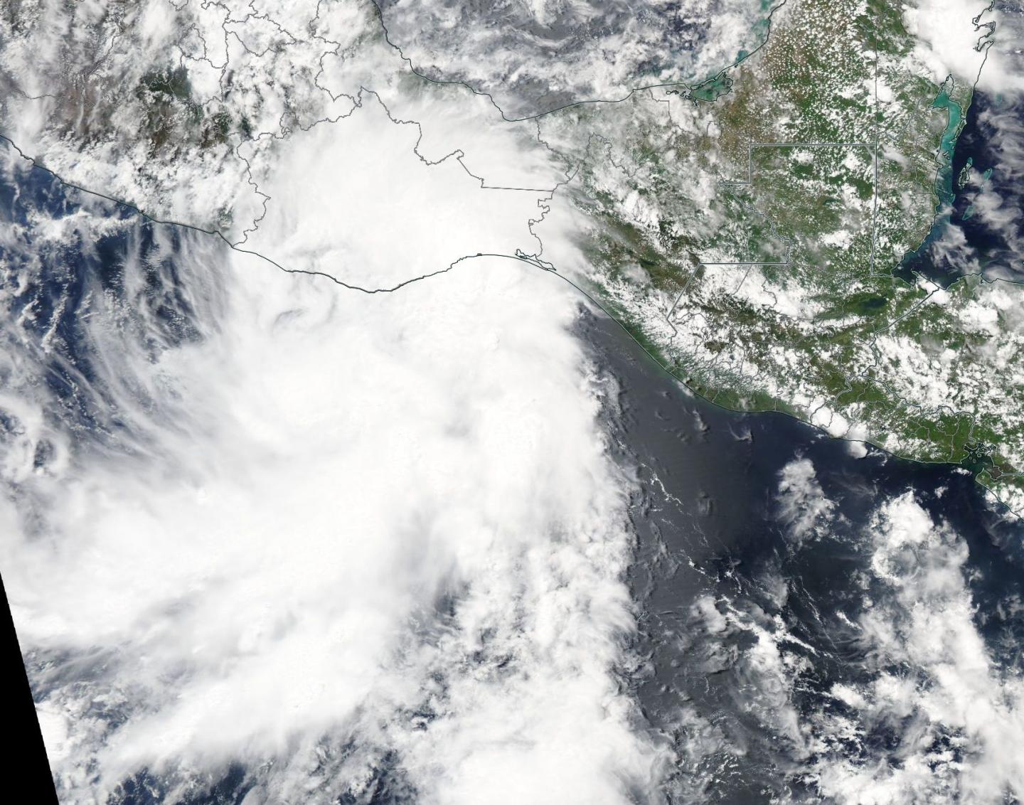
NASA's Aqua satellite analyzed Tropical Depression 2E in infrared, visible and microwave light as it began its landfall on June 1, bringing heavy rains to southern Mexico.

Tropical Depression 02E (TD2E) formed on May 31 and has not strengthened, likely due to its close proximity to the coast of southern Mexico. The National Hurricane Center (NHC) said that Tropical Depression 2E's "central convection has decreased somewhat, with the primary convection now in a large band over the southeastern semicircle."

The Atmospheric Infrared Sounder or AIRS instrument aboard NASA's Aqua satellite looked at Tropical Depression 2E in infrared light. The AIRS image was taken on June 1 at 7:41 UTC (3:41 a.m. EST) and showed some cloud top temperatures of thunderstorms near the center of circulation as cold as minus 63 degrees Fahrenheit (minus 53 degrees Celsius). NASA research has shown the storms with cloud tops that cold have the potential to generate heavy rainfall. The image shows that the northern quadrant containing those strong storms extended over southern Mexico.

The infrared data was false-colored at NASA's Jet Propulsion Laboratory in Pasadena, California, where AIRS data is managed.

The MODIS instrument aboard Aqua captured a visible image of Tropical Depression 2E at the same time as the AIRS instrument. The MODIS image clearly showed the northern extent of TD2E over the Mexican state of Oaxaca.

A Tropical Storm Warning is in effect for the Pacific coast of Mexico from Salina Cruz to Puerto Escondido.

The NHC noted at 11 a.m. EDT on June 1 the center of TD2E was located near latitude 15.4 degrees North and longitude degrees 97.1 West. That's about 45 miles (70 km) west-southwest of Puerto Angel, Mexico and about 215 miles (340 km) east-southeast of Acapulco, Mexico.

NHC said "The depression is moving toward the north-northeast near 6 mph (9 kph) and this motion is expected to continue through Friday. On the forecast track, the center of the tropical cyclone is expected to move inland across the state of Oaxaca later today or tonight. Maximum sustained winds are near 35 mph (55 kph) with higher gusts."

There's a chance that the depression could still become a tropical storm before landfall.

After landfall, the system is expected to weaken and dissipate on Friday over the mountains if southeastern Mexico.

###

Media Contact

Rob Gutro
[email protected]
@NASAGoddard

http://www.nasa.gov/goddard

############

Story Source: Materials provided by Scienmag

Share12Tweet7Share2ShareShareShare1

Related Posts

Rare Genetic Variants Linked to ADHD Risk

November 13, 2025

Enhancing Teamwork in Healthcare: A Visual Framework

November 13, 2025

Climate Change Reshapes Global Carbon Sinks

November 13, 2025

TRIM25 Loss Boosts Cancer Immunotherapy via VISTA

November 13, 2025
Please login to join discussion

POPULAR NEWS

  • blank

    Stinkbug Leg Organ Hosts Symbiotic Fungi That Protect Eggs from Parasitic Wasps

    317 shares
    Share 127 Tweet 79
  • ESMO 2025: mRNA COVID Vaccines Enhance Efficacy of Cancer Immunotherapy

    209 shares
    Share 84 Tweet 52
  • New Study Suggests ALS and MS May Stem from Common Environmental Factor

    141 shares
    Share 56 Tweet 35
  • Sperm MicroRNAs: Crucial Mediators of Paternal Exercise Capacity Transmission

    1306 shares
    Share 522 Tweet 326

About

We bring you the latest biotechnology news from best research centers and universities around the world. Check our website.

Follow us

Recent News

Rare Genetic Variants Linked to ADHD Risk

Enhancing Teamwork in Healthcare: A Visual Framework

Climate Change Reshapes Global Carbon Sinks

Subscribe to Blog via Email

Enter your email address to subscribe to this blog and receive notifications of new posts by email.

Join 69 other subscribers
  • Contact Us

Bioengineer.org © Copyright 2023 All Rights Reserved.

Welcome Back!

Login to your account below

Forgotten Password?

Retrieve your password

Please enter your username or email address to reset your password.

Log In
No Result
View All Result
  • Homepages
    • Home Page 1
    • Home Page 2
  • News
  • National
  • Business
  • Health
  • Lifestyle
  • Science

Bioengineer.org © Copyright 2023 All Rights Reserved.