• HOME
  • NEWS
  • EXPLORE
    • CAREER
      • Companies
      • Jobs
    • EVENTS
    • iGEM
      • News
      • Team
    • PHOTOS
    • VIDEO
    • WIKI
  • BLOG
  • COMMUNITY
    • FACEBOOK
    • INSTAGRAM
    • TWITTER
Tuesday, September 16, 2025
BIOENGINEER.ORG
No Result
View All Result
  • Login
  • HOME
  • NEWS
  • EXPLORE
    • CAREER
      • Companies
      • Jobs
        • Lecturer
        • PhD Studentship
        • Postdoc
        • Research Assistant
    • EVENTS
    • iGEM
      • News
      • Team
    • PHOTOS
    • VIDEO
    • WIKI
  • BLOG
  • COMMUNITY
    • FACEBOOK
    • INSTAGRAM
    • TWITTER
No Result
View All Result
Bioengineer.org
No Result
View All Result
Home NEWS Science News

NASA sees Tropical Cyclone Debbie make landfall in Queensland

Bioengineer by Bioengineer
March 28, 2017
in Science News
Reading Time: 2 mins read
0
Share on FacebookShare on TwitterShare on LinkedinShare on RedditShare on Telegram
IMAGE

Credit: Credits: NASA/NOAA

Tropical Cyclone Debbie made landfall in Queensland bringing heavy rainfall, hurricane-force winds, rough seas, and flooding. NASA-NOAA's Suomi NPP satellite provided a visible look at the storm from space while NASA's Aqua satellite analyzed cloud temperatures to determine the location of the strongest storms within.

Before Debbie made landfall, NASA's Aqua satellite analyzed the temperatures in the storm on Mar. 27 at 0347 UTC (Mar. 26 at 11:47 pm. EST). The infrared imagery showed a large area of cloud top temperatures in thunderstorms around Debbie's eye as cold as near minus 63.1 degrees Celsius or minus 81.6 degrees Fahrenheit. Cloud top temperatures that cold have been shown to produce heavy rainfall.

Cyclone Debbie made landfall north of Proserpine at Airlie Beach on March 28, shortly after noon AEST/Queensland local time (0200 UTC/March 27 at 10 p.m. EST). The Australian Bureau of Meteorology noted wind gusts stronger than 160 mph (260 kph) were recorded near landfall.

The strong winds downed trees and powerlines. Power losses occurred in a large area between the towns of Bowen and Mackay, according to Ergon Energy. The Townsville airport and ocean ports were closed.

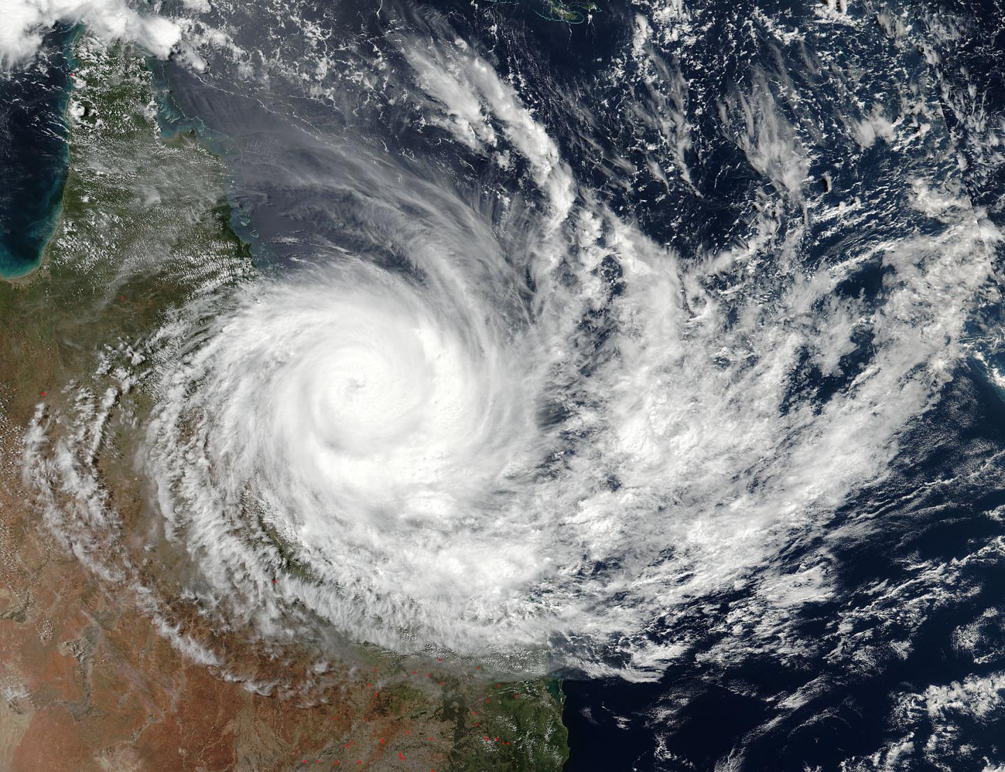
Shortly after Debbie's 30-mile-wide (50 km) eye made landfall, the VIIRS instrument aboard NASA-NOAA's Suomi NPP satellite captured a visible image of the storm at 03:42 UTC (1:42 p.m. AEST Queensland local time /Mar. 27 at 11:42 p.m. EST). The image showed a thick band of powerful thunderstorms wrapped around the cloud-filled eye.

At 11:58 p.m. AEST/Queensland local time (9:58 a.m. EST/U.S.), the Australian Bureau of Meteorology (ABM) noted that the Warning Zone extended from Bowen to St Lawrence, including Mackay and the Whitsunday Islands, and extending inland to Mount Coolon and Moranbah.

At that time, ABM noted that maximum sustained winds near Debbie's center were near 52.8 mph (85 kph) with higher gusts. Debbie was centered near 20.8 degrees south latitude and 147.5 degrees east longitude, about 71.4 miles (115 kilometers) west southwest of Proserpine and 24.8 miles (40 kilometers) southwest of Collinsville. Debbie continued to move inland in a west-southwesterly direction at (9.3 mph) 15 kph.

ABM noted "Tropical cyclone Debbie is expected to weaken further to a tropical low during the next few hours. During the day today, this remnant low will curve from the current southwesterly motion to a more southerly track over inland Queensland.

Although the peak winds near Debbie's center are weakening rapidly tonight, heavy rainfall is expected to continue across the region for the next 12 to 24 hours, gradually contracting southwards with the system."

For additional updates from ABM, visit: http://www.bom.gov.au/cyclone/index.shtml.

Cyclone Debbie was the most powerful storm to make landfall in Queensland since Cyclone Yasi in 2011.

###

Media Contact

Rob Gutro
[email protected]
@NASAGoddard

http://www.nasa.gov/goddard

############

Story Source: Materials provided by Scienmag

Share12Tweet8Share2ShareShareShare2

Related Posts

blank

How Placental Research Could Revolutionize Our Understanding of Autism and Human Brain Evolution

September 16, 2025
blank

Pueraria lobata and Puerarin Boost Dopamine Activity

September 16, 2025

Study Identifies Population Aging as Key Driver of Musculoskeletal Disorders

September 16, 2025

Charting the Universe: Faster Mapping with Unmatched Precision

September 16, 2025
Please login to join discussion

POPULAR NEWS

  • blank

    Breakthrough in Computer Hardware Advances Solves Complex Optimization Challenges

    154 shares
    Share 62 Tweet 39
  • New Drug Formulation Transforms Intravenous Treatments into Rapid Injections

    116 shares
    Share 46 Tweet 29
  • Physicists Develop Visible Time Crystal for the First Time

    66 shares
    Share 26 Tweet 17
  • A Laser-Free Alternative to LASIK: Exploring New Vision Correction Methods

    49 shares
    Share 20 Tweet 12

About

We bring you the latest biotechnology news from best research centers and universities around the world. Check our website.

Follow us

Recent News

How Placental Research Could Revolutionize Our Understanding of Autism and Human Brain Evolution

Pueraria lobata and Puerarin Boost Dopamine Activity

Study Identifies Population Aging as Key Driver of Musculoskeletal Disorders

  • Contact Us

Bioengineer.org © Copyright 2023 All Rights Reserved.

Welcome Back!

Login to your account below

Forgotten Password?

Retrieve your password

Please enter your username or email address to reset your password.

Log In
No Result
View All Result
  • Homepages
    • Home Page 1
    • Home Page 2
  • News
  • National
  • Business
  • Health
  • Lifestyle
  • Science

Bioengineer.org © Copyright 2023 All Rights Reserved.