• HOME
  • NEWS
  • EXPLORE
    • CAREER
      • Companies
      • Jobs
    • EVENTS
    • iGEM
      • News
      • Team
    • PHOTOS
    • VIDEO
    • WIKI
  • BLOG
  • COMMUNITY
    • FACEBOOK
    • INSTAGRAM
    • TWITTER
Saturday, February 7, 2026
BIOENGINEER.ORG
No Result
View All Result
  • Login
  • HOME
  • NEWS
  • EXPLORE
    • CAREER
      • Companies
      • Jobs
        • Lecturer
        • PhD Studentship
        • Postdoc
        • Research Assistant
    • EVENTS
    • iGEM
      • News
      • Team
    • PHOTOS
    • VIDEO
    • WIKI
  • BLOG
  • COMMUNITY
    • FACEBOOK
    • INSTAGRAM
    • TWITTER
No Result
View All Result
Bioengineer.org
No Result
View All Result
Home NEWS Science News

NASA sees ex-Tropical Cyclone Debbie over Queensland

Bioengineer by Bioengineer
March 29, 2017
in Science News
Reading Time: 2 mins read
0
Share on FacebookShare on TwitterShare on LinkedinShare on RedditShare on Telegram
IMAGE

Credit: Credits: NASA/NOAA

NASA-NOAA's Suomi NPP satellite passed over Ex-Tropical Cyclone Debbie after it made landfall in eastern Queensland and weakened.

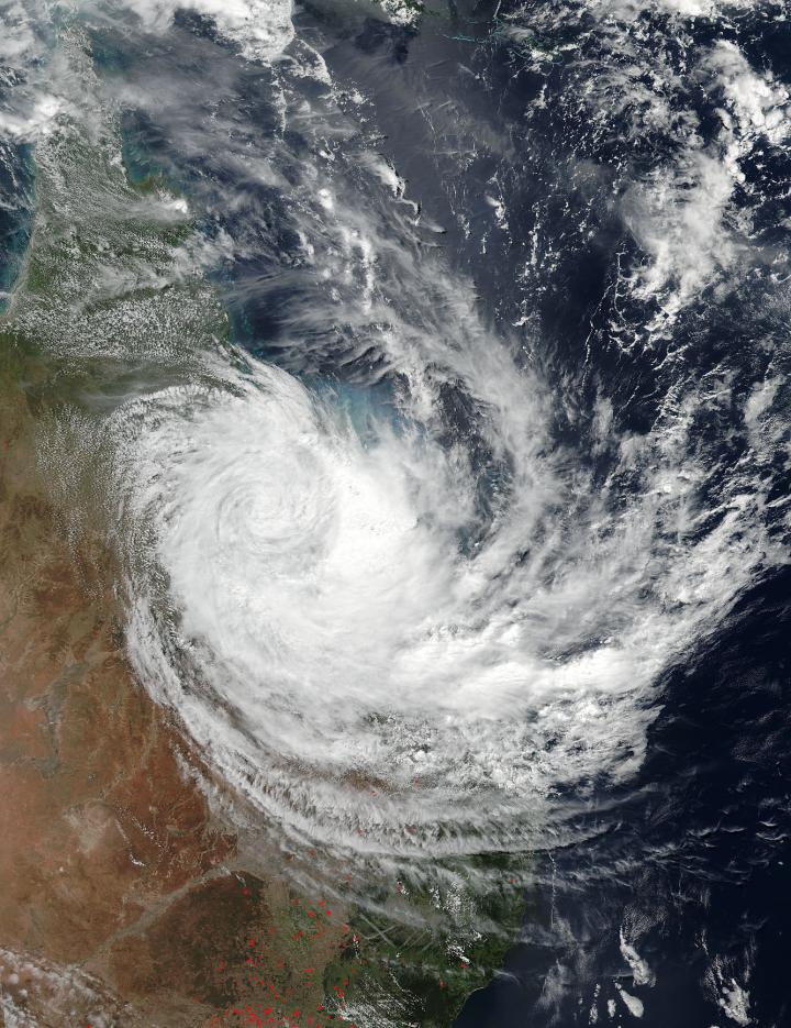
On March 29, 2017 at 0324 UTC or 1:24 p.m. AEST/Queensland local time (Mar. 28 11:24 p.m. EST) the Visible Infrared Imaging Radiometer Suite (VIIRS) instrument aboard the NASA-NOAA Suomi NPP satellite captured this a image of Ex-Tropical Cyclone Debbie over Queensland, Australia. Debbie weakened below hurricane-force and its eye filled in with clouds. The image showed the system's clouds stretched from Townsville in the north, south to Brisbane along the coast. Debbie's center of circulation appeared to be west of Mount Coolon at the time of the image.

A 9 p.m. AEST (7 a.m. EST/U.S.) the Australian Bureau of Meteorology or ABM reported that Ex-Tropical Cyclone Debbie was located over inland central Queensland near Clermont. Debbie is expected to continue moving in a southerly direction over the central interior of the state overnight before tracking southeastward on Thursday, March 30 (AEST local time).

Heavy rainfall remains a threat as it does when a tropical system moves inland. Debbie is expected to generate areas of very heavy rain over the Capricornia, Central Coast and Whitsundays and Central Highlands and Coalfields districts this evening. ABM said, "Currently the heaviest rainfall is occurring over the areas inland and south of Mackay with rainfall rates in excess of 5.9 inches (150mm) over a 3 hour period. Outside this area widespread daily rainfall totals of 5.9 to 9.8 inches (150 to 250 mm) are expected, with significantly higher totals possible locally. This rainfall will likely be very intense at times, leading to a risk of localized flash flooding. Locations that may be affected include Mackay, Sarina, Carmila, Yeppoon, St Lawrence, Springsure and Rolleston. The focus for heavy rain will then shift south and extend into the southeastern quarter of the state during Thursday, with widespread daily rainfall totals in excess of 7.8 inches (200 mm) possible."

ABM issued a Flood Watch "for coastal catchments between Gladstone and the New South Wales border, extending inland to parts of the Central Highlands and Coalfields, Central West, Maranoa and Warrego, and Darling Downs and Granite Belt forecast districts."

In addition to heavy rain and flooding, tropical storm force and hurricane force winds are possible, according to ABM. "Damaging winds, with peak gusts of around 62 mph (100 kph), are occurring in the warning area, particularly about the coast and islands and also over elevated terrain inland. Currently the strongest wind gusts are affecting areas north of about Emerald to St Lawrence, however the possibility of damaging wind gusts should shift to the remaining warning area as Ex-Tropical Cyclone Debbie tracks southeastwards tonight and Thursday morning.

Destructive wind gusts, in excess of 77.7 mph (125 kph), are expected to develop about the coastal areas and elevated terrain of the Wide Bay and Burnett and Southeast Coast districts from Thursday afternoon."

###

For updates from ABM, visit: http://www.bom.gov.au/qld/warnings/.

Media Contact

Rob Gutro
[email protected]
@NASAGoddard

http://www.nasa.gov/goddard

############

Story Source: Materials provided by Scienmag

Share12Tweet8Share2ShareShareShare2

Related Posts

Succinate Receptor 1 Limits Blood Cell Formation, Leukemia

February 7, 2026

Palmitoylation of Tfr1 Drives Platelet Ferroptosis and Exacerbates Liver Damage in Heat Stroke

February 7, 2026

Oxygen-Enhanced Dual-Section Microneedle Patch Improves Drug Delivery and Boosts Photodynamic and Anti-Inflammatory Treatment for Psoriasis

February 7, 2026

Scientists Identify SARS-CoV-2 PLpro and RIPK1 Inhibitors Showing Potent Synergistic Antiviral Effects in Mouse COVID-19 Model

February 7, 2026
Please login to join discussion

POPULAR NEWS

  • Robotic Ureteral Reconstruction: A Novel Approach

    Robotic Ureteral Reconstruction: A Novel Approach

    82 shares
    Share 33 Tweet 21
  • Digital Privacy: Health Data Control in Incarceration

    63 shares
    Share 25 Tweet 16
  • Study Reveals Lipid Accumulation in ME/CFS Cells

    57 shares
    Share 23 Tweet 14
  • Breakthrough in RNA Research Accelerates Medical Innovations Timeline

    53 shares
    Share 21 Tweet 13

About

We bring you the latest biotechnology news from best research centers and universities around the world. Check our website.

Follow us

Recent News

Succinate Receptor 1 Limits Blood Cell Formation, Leukemia

Palmitoylation of Tfr1 Drives Platelet Ferroptosis and Exacerbates Liver Damage in Heat Stroke

Oxygen-Enhanced Dual-Section Microneedle Patch Improves Drug Delivery and Boosts Photodynamic and Anti-Inflammatory Treatment for Psoriasis

Subscribe to Blog via Email

Enter your email address to subscribe to this blog and receive notifications of new posts by email.

Join 73 other subscribers
  • Contact Us

Bioengineer.org © Copyright 2023 All Rights Reserved.

Welcome Back!

Login to your account below

Forgotten Password?

Retrieve your password

Please enter your username or email address to reset your password.

Log In
No Result
View All Result
  • Homepages
    • Home Page 1
    • Home Page 2
  • News
  • National
  • Business
  • Health
  • Lifestyle
  • Science

Bioengineer.org © Copyright 2023 All Rights Reserved.