Human and economic losses inflicted by disasters are still growing in the world in spite of technological advances. A recent case study from Estonia shows that mobile positioning data can play a key role in improving the availability of emergency assistance, reducing the risk to human life and health in crisis situations.
Researchers from the University of Tartu together with private company Positium and the Estonian Rescue Board have developed a novel method for using mobile phone data to estimate the de facto population and population groups in potential disaster areas, and to assess population groups’ spatio-temporal variation and vulnerability. Even though the case study is conducted on Estonian data, researchers are convinced that their methodology can be applied to other countries and regions, and that these findings can inform policymakers and emergency managers in planning and implementing disaster prevention and response measures more effectively.
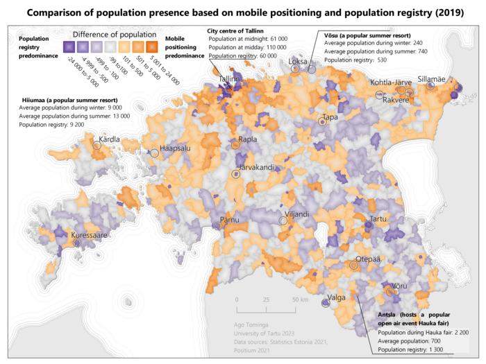
Mobile positioning data has been used in both scientific and applied research in Estonia for more than 15 years. The mobile positioning data based on mobile network operators includes anonymized information about the location and time of mobile phone use. The location is based on the network antenna that provided the network signal the phone was connected to. Researchers have developed a methodology to identify how many local and temporary residents, workers, domestic and foreign tourists and random visitors there are in different places at different times. The methodology uses historical passive mobile positioning data to identify these population groups based on their mobility patterns.
Registry-based information is not enough in a crisis
Traditional, registry-based methods have limitations when it comes to tracking people’s whereabouts during disasters. “Mobile positioning data can offer a timely solution that improves evacuation planning, resource allocation, and emergency communication, “said Ago Tominga, Junior Research Fellow of Human Geography at the University of Tartu and the leading author of the study.
The study showed that variability of within-area population presence is high, but can be well-explained by daily, weekly, seasonal and locational factors, as well as national-level cultural events. “The variability highlights the need to estimate the presence of the population more accurately over time and to include information on temporary populations as part of disaster management, “explained Tominga. People can become vulnerable in various ways based on their role: a local resident may be at risk of losing a house or having nowhere to go, whereas tourists and transit visitors may not be familiar with local context or information sources.
Study designed together with the rescue board
The study stands out among others in the field because rescue workers were involved already in the planning phase of the study to make sure that it answers their needs in the best way. According to Tominga, this helps to ensure that the application is validated based on scenarios displaying how crisis managers will actually use it. Moreover, having sufficient time to familiarize themselves with a new information source is of vital importance for rescuers in order to make quick decisions in an acute crisis.
The rescue workers involved in this research stated that dynamic information on population placement would help them fill information gaps in disaster preparation and response activities. Moreover, both authors and rescue workers agree that the early inclusion of emergency managers in the research and development process is one of the keys to the effective adoption of novel methodologies.
Similar methodologies and statistics for spatial and temporal distribution of distinct population groups are also useful in other areas where it is necessary to know where, when and which people are in certain places, e.g. in urban and regional planning or transport planning.
Now, the research group is looking more specifically at how mobile positioning-based population statistics can improve decision-making processes in crisis management in both national and international settings.
The study demonstrates the potential of using mobile phone data as a dynamic source of information for disaster risk reduction. The study was published in the International Journal of Disaster Risk Reduction.
Credit: Author: Ago Tominga
Human and economic losses inflicted by disasters are still growing in the world in spite of technological advances. A recent case study from Estonia shows that mobile positioning data can play a key role in improving the availability of emergency assistance, reducing the risk to human life and health in crisis situations.
Researchers from the University of Tartu together with private company Positium and the Estonian Rescue Board have developed a novel method for using mobile phone data to estimate the de facto population and population groups in potential disaster areas, and to assess population groups’ spatio-temporal variation and vulnerability. Even though the case study is conducted on Estonian data, researchers are convinced that their methodology can be applied to other countries and regions, and that these findings can inform policymakers and emergency managers in planning and implementing disaster prevention and response measures more effectively.
Mobile positioning data has been used in both scientific and applied research in Estonia for more than 15 years. The mobile positioning data based on mobile network operators includes anonymized information about the location and time of mobile phone use. The location is based on the network antenna that provided the network signal the phone was connected to. Researchers have developed a methodology to identify how many local and temporary residents, workers, domestic and foreign tourists and random visitors there are in different places at different times. The methodology uses historical passive mobile positioning data to identify these population groups based on their mobility patterns.
Registry-based information is not enough in a crisis
Traditional, registry-based methods have limitations when it comes to tracking people’s whereabouts during disasters. “Mobile positioning data can offer a timely solution that improves evacuation planning, resource allocation, and emergency communication, “said Ago Tominga, Junior Research Fellow of Human Geography at the University of Tartu and the leading author of the study.
The study showed that variability of within-area population presence is high, but can be well-explained by daily, weekly, seasonal and locational factors, as well as national-level cultural events. “The variability highlights the need to estimate the presence of the population more accurately over time and to include information on temporary populations as part of disaster management, “explained Tominga. People can become vulnerable in various ways based on their role: a local resident may be at risk of losing a house or having nowhere to go, whereas tourists and transit visitors may not be familiar with local context or information sources.
Study designed together with the rescue board
The study stands out among others in the field because rescue workers were involved already in the planning phase of the study to make sure that it answers their needs in the best way. According to Tominga, this helps to ensure that the application is validated based on scenarios displaying how crisis managers will actually use it. Moreover, having sufficient time to familiarize themselves with a new information source is of vital importance for rescuers in order to make quick decisions in an acute crisis.
The rescue workers involved in this research stated that dynamic information on population placement would help them fill information gaps in disaster preparation and response activities. Moreover, both authors and rescue workers agree that the early inclusion of emergency managers in the research and development process is one of the keys to the effective adoption of novel methodologies.
Similar methodologies and statistics for spatial and temporal distribution of distinct population groups are also useful in other areas where it is necessary to know where, when and which people are in certain places, e.g. in urban and regional planning or transport planning.
Now, the research group is looking more specifically at how mobile positioning-based population statistics can improve decision-making processes in crisis management in both national and international settings.
The study demonstrates the potential of using mobile phone data as a dynamic source of information for disaster risk reduction. The study was published in the International Journal of Disaster Risk Reduction.
Journal
International Journal of Disaster Risk Reduction
DOI
10.1016/j.ijdrr.2023.103887
Method of Research
Case study
Subject of Research
People
Article Title
Mobile positioning-based population statistics in crisis management: An Estonian case study
Article Publication Date
1-Oct-2023
COI Statement
There is no conflict of interest.


