Credit: NASA
On Sept. 21, 2014, NASA scientists and engineers launched RapidScat toward the orbiting International Space Station, 250 miles above the Earth's surface, with a few objectives in mind: improve weather forecasting on Earth, provide cross-calibration for all international satellites that monitor ocean winds, and improve estimates of how ocean winds change throughout the day, around the globe.
Rapid Scat Gif
RapidScat's radar technology used microwaves, bounced off the ocean's surface, to determine wind speed and direction.
Credits: NASA
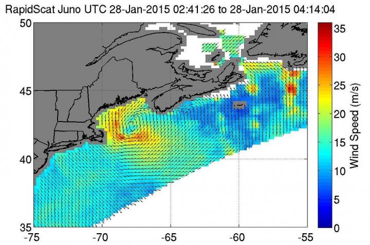
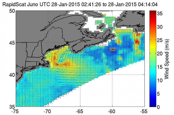
On Jan. 28, 2015, ISS-RapidScat saw the Nor'easter's strongest sustained winds (red) between 56 and 67 mph
On Jan. 28, 2015, ISS-RapidScat saw the Nor'easter's strongest sustained winds (red) between 56 and 67 mph just off-shore from Eastern Cape Cod.
Credits: NASA
ISS-RapidScat data on a North Atlantic extratropical cyclone
ISS-RapidScat data on a North Atlantic extratropical cyclone, as seen by the National Centers for Environmental Prediction Advanced Weather Interactive Processing System used by weather forecasters at NOAA's Ocean Prediction Center.
Credits: NASA/JPL-Caltech/NOAA
Following the 2009 end of mission of QuikScat, a similar instrument on a free-flying satellite in operation before RapidScat, NASA was challenged with the task of engineering a replacement device – and quickly — as the data QuikScat provided had helped meteorologists to predict weather patterns and prepare for large storm systems for more than a decade. Using the existing data and power services of the station and hardware initially built as a spare for QuikScat, RapidScat not only recreated its predecessors work, but greatly improved the timeliness of data transmissions and the potential for cross-calibration of other sensors designed to measure sea-surface winds. RapidScat data was used all over the world by government laboratories and meteorological agencies, scientists, private companies, students and individuals to track the progression of a storm's strength.
Because of its ability to monitor weather systems around the world, RapidScat played a vital role in storm prediction and allowed maritime and air traffic time to avoid potentially dangerous weather conditions. RapidScat's radar technology used microwaves, bounced off the ocean's surface, to determine wind speed and direction. Choppy, large waves send back stronger signals, indicating that heavy winds are present in the area.
RapidScat observations played an essential role in National Oceanic and Atmospheric Administration (NOAA) weather forecasting by aiding in their ability to measure temporal changes of wind fields and allowing them to study changes within one hour in high latitudes, compared to six hours with previous instruments.
Wind speed is not only important in the prediction of bad weather and investigation of global wind circulation patterns, but also helps organizations like NASA to plan launches, flights and landings of space- and aircrafts. RapidScat aided in the successful NASA Orion test flight by providing near-real-time wind speeds, allowing NASA to choose a safe landing zone for the spacecraft.
The station's orbit is not synchronized with Earth's rotation, as all other space borne scatterometers currently are. This made the station an ideal home for the RapidScat instrument because its orbit allowed it to intersect and cross-calibrate with the international constellation of scatterometers. This paved the way to measure and compare data from various scatterometers, together providing wind measurements multiple times each day, giving meteorologists and other scientists a better look into how storms developed. Moving forward, these organizations will use data transmitted from the newly-launched ScatSat, an ocean wind sensor instrument of the Indian Space Research Organization.
RapidScat completed its successful two-year mission, outlasting its original decommission date before suffering a power loss in mid-August. Although RapidScat is no longer transmitting data back to Earth, the station hosts many other Earth-observation tools and investigations such as Crew Earth Observations, an investigation which arms crew members with handheld digital cameras to observe how the Earth changes over time, from human-caused changes to natural disasters (including storm systems); the Cyclone Intensity Measurements from the ISS or CyMISS ( also known as the Tropical Cyclone project), a Center for the Advancement of Science in Space (CASIS)-funded Earth-Observation experiment that seeks to develop detailed information on tropical storm structure to better estimate storm intensity, which will help government agencies to better prepare communities for impending natural disasters; and the Cloud-Aerosol Transport System (CATS), a lidar instrument measuring atmospheric profiles of aerosols and clouds to better understand their properties and interactions, as well as providing data useful to improving climate change models
###
For a more in-depth look at the RapidScat mission, visit http://winds.jpl.nasa.gov/missions/RapidScat/.
Media Contact
Rachel Hobson
[email protected]
281-244-7449
@NASA_Johnson
http://www.nasa.gov/centers/johnson/home
############
Story Source: Materials provided by Scienmag


