Whether birds get caged in the eye of a hurricane may depend on the intensity and totality of the chaos beyond the calm, says a novel study from the University of Nebraska–Lincoln’s Matthew Van Den Broeke.
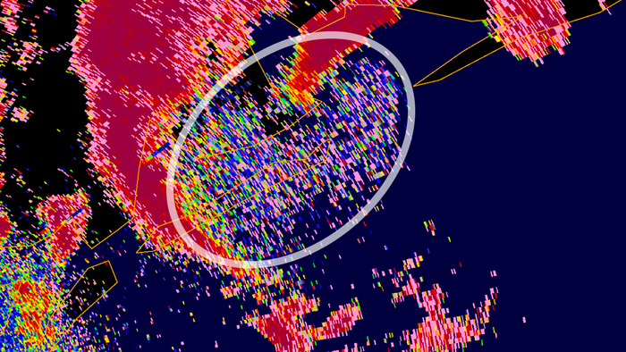
Credit: Remote Sensing in Ecology and Conservation / John Wiley & Sons, Inc.
Whether birds get caged in the eye of a hurricane may depend on the intensity and totality of the chaos beyond the calm, says a novel study from the University of Nebraska–Lincoln’s Matthew Van Den Broeke.
Reports of birds being trapped in the center of hurricanes date back to at least the 19th century, when crews observed the phenomenon from the bows of ships and saw their vessels become mobile ports for exhausted birds.
“It’s been really fun reading some of these older observations from the 1800s about taking a ship through a hurricane eye and watching birds landing on it,” said Van Den Broeke, associate professor of Earth and atmospheric sciences. “So we’ve known for a long time that this happens.
“But it’s really only since (the advent of) radar observations that we have gotten any sense of how many of these systems actually do transport birds and insects.”
The technology that allowed meteorologists to really begin differentiating weather from organisms — dual-polarimetric radar, which added a second, vertical dimension to previously one-dimensional observations — became widely available only in the past 10 years. Which means that much still remains unclear about when, how often and under what conditions a hurricane turns a free bird into a whirlybird.
Van Den Broeke set out to analyze the dual-pol data from 33 Atlantic hurricanes that struck either the U.S. coast or Puerto Rico between 2011 and 2020. Those 33 included some of the most ferocious hurricanes in recent memory: Irene in 2011, Sandy in 2012, Harvey and Irma in 2017, Dorian in 2019.
He was hunting specifically for bioscatter signatures — the electromagnetic, speed-of-light waves that bounced back to a radar station not from the precipitation encircling the eye, but from birds or even insects within. In every one of the 33 cases, Van Den Broeke identified at least some bioscatter.
But the signatures differed. Tellingly, those differences generally corresponded with differences in the hurricanes themselves. The greater the wind speed of a hurricane, the denser and sometimes larger the bioscatter signature was, indicating the presence of more birds within the eye. Van Den Broeke also classified the hurricanes according to whether their eyes were closed, open or somewhere in between. A closed eye was 100% surrounded by thunderstorms, whereas a mostly closed eye was 75%-99% surrounded, and so on. As with wind speed, greater thunderstorm coverage generally correlated with more birds.
Of course, stronger winds and more thunderstorms tend to go together, Van Den Broeke said, making it difficult to tease apart the precise influences of wind speed vs. precipitation. What is clear: The more severe the hurricane, the more daunting the prospect of abandoning the relative safety of the eye — even if it might mean spending thousands of miles and a week in the air.
Though the intensity of a hurricane may hold the greatest sway, Van Den Broeke came across evidence that timing and geography matter, too. The largest bioscatter signatures appeared in hurricanes that occurred between July and October, when many bird species are migrating southward to the tropics, suggesting that native seabirds are not alone in getting swept up. Bioscatter was also larger and denser, on average, in hurricanes that struck the Gulf Coast and Florida, which boast a larger concentration and diversity of birds than other areas struck by the recorded hurricanes.
That could have ecological implications, Van Den Broeke said, especially if the strength and frequency of Atlantic hurricanes are growing in response to global warming. Population dynamics could hypothetically be skewed, or invasive species introduced, by a hurricane of the right intensity crossing a migratory route at the wrong time.
“Ecologists think about transport quite a bit,” he said. “How do you get organisms from one point to another? How many organisms are being transported? Are you able to transport new species that weren’t previously present? Can you transport pests that might be a threat to agriculture?”
The question of just how many birds might be transported by a single hurricane is a murky one, and probably unanswerable without knowing which species are trapped within the eye, Van Den Broeke said. Other lingering questions, though, should prove more resolvable.
In his recent study, Van Den Broeke discovered that the cruising altitude of trapped birds also increases in tandem with hurricane intensity. He’s unsure why, though it may have to do with the thermal structure of a typical hurricane. Hot, moist air near the water’s surface tends to rise up the eye until it reaches a boundary, called the inversion, beyond which the higher, drier air tends to sink. Inversion altitude can vary substantially among hurricanes and might be affecting that of the birds, Van Den Broeke said.
He’s now analyzing inversion data collected by parachuted instruments, called dropsondes, that are released within hurricanes from aircraft flown by the U.S. Air Force and the National Oceanic and Atmospheric Administration.
“I’m comparing the observations of inversion height to the bioscatter signatures,” said Van Den Broeke, whose work is supported by the National Science Foundation. “Does it match up? Do birds fly above that? Below it? And can we say something, then, about intensity changes in tropical cyclones, and relate that to how the bioscatter signature behaved?
“It’s possible there’s some kind of systematic effect there.”
If so, bioscatter altitude might eventually become a radar-based proxy for hurricane traits that can currently be measured only via dropsonde. In the meantime, Van Den Broeke, who once considered a career in ecology and still has a penchant for it, said he’s relishing the chance to bridge two fields that rarely overlap.
“I’m always fascinated by ecosystems and the interactions of organisms with their environment,” he said. “But my expertise is in meteorology, so to be able to combine the two fields is really exciting to me.”
Journal
Remote Sensing in Ecology and Conservation
DOI
10.1002/rse2.225
Subject of Research
Not applicable
Article Title
Bioscatter transport by tropical cyclones: insights from 10 years in the Atlantic basin


