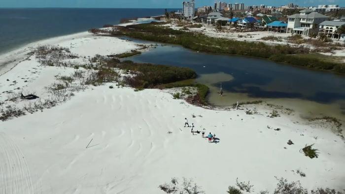
Category 4 Hurricane Ian made landfall in Florida’s Lee County on Sept. 28, 2022, battering the region with wind speeds of 155 miles per hour and storm surge up to 13 feet – the highest storm surge documented in Southwest Florida in the past 150 years.
Credit: Ryan Sloan and James Gammack-Clark, Florida Atlantic University
Category 4 Hurricane Ian made landfall in Florida’s Lee County on Sept. 28, 2022, battering the region with wind speeds of 155 miles per hour and storm surge up to 13 feet – the highest storm surge documented in Southwest Florida in the past 150 years.
In the aftermath of a disaster, rapidly assessing damage is critical for rescue, recovery and emergency planning. Damage assessments are typically conducted through field reconnaissance deployments, which can be labor-intensive, costly and risky. Moreover, field-based emergency response assessments can be hindered by delays and other setbacks due to the severity of the damage and the inability to access the hardest hit areas.
Using remote sensing technology, Florida Atlantic University researchers have developed a novel technique that provides rapid, high-resolution assessments of detailed damage after a hurricane. Using aerial imagery data and LiDAR, they identified the hardest-hit areas of Southwest Florida’s Estero Island and estimated the extent of structural damage. Researchers also compared pre- and post-storm structural or morphological changes to the beach. The study is the first to apply an advanced multi-faceted approach that links damage assessment to post-storm change in the structure of barrier islands.
Results of the study, published in the Journal of Marine Science and Engineering, identified a total of 2,427 structures on Estero Island that were impacted by Hurricane Ian, with 170 structures suffering extensive damage. A single store was the only structure in the study area classified as “not affected.”
Using data from the Lee County tax appraiser, researchers estimated the total assessed value of the heavily damaged structures at more than $200 million.
Overall, 734 buildings had 30 to 50 percent structural damage, the majority of which were single-family and multi-unit residences. Researchers identified 158 buildings that were severely damaged with partial or complete roof failure.
The highest percentage of damaged structures occurred on the central and northern portions of the island, where most of the structures were single-family and multi-family residences. Most of the structures that experienced 0 to 30 percent damage were classified as low-rise condominiums (three stories or less), commercial shopping centers and stores. Among the “severely damaged” and “destroyed” structures were seven mobile home subdivisions.
“Employing this advanced technology of aerial imagery and airborne LiDAR enabled us to collect extensive data from Hurricane Ian’s aftermath and analyze large-scale datasets rather quickly,” said Tiffany Roberts Briggs, Ph.D., senior author, chair and an associate professor in the Department of Geosciences within FAU’s Charles E. Schmidt College of Science.
The 2,427 structures were built between 1963 to 2019. The buildings in the areas where less damage was observed were built between 1963 and 1981. Similarly, in the areas of heavy damage, the majority of the buildings were built between 1963 and 1981. The spatial distribution of ground elevation and year built indicated no apparent trends associated with these two variables.
“We found no correlation between the ground elevation or year built for the extent of damages in this analysis, which emphasizes the role of the extreme inundation and importance of other factors contributing to vulnerability,” said Roberts Briggs. “Results from our study can help improve disaster planning by developing new policies and guidelines for coastal development in some of the most vulnerable and storm-exposed areas.”
Areas associated with little to no damage were spatially clustered in the southern and central portion of the island, with most structures concentrated on the landward side of the barrier island.
“The southern portion of Estero Island contains multiple saltwater marshes,” said Leanne Hauptman, first author and a Ph.D. student in FAU’s Department of Geosciences. “Because of these saltwater marshes, storm-wave energy may been substantially dissipated by friction by the time the waves reached the barrier interior, potentially lessening the impact on the structures in that area.”
Findings also showed substantial post-storm debris and sand deposition across the entire island, and a notable deposition of sediment across the roadways and on the backside of the barrier, which is not readily returned seaward to the beach under post-storm conditions. Ponding water also was found hundreds of meters inland near buildings and other structures, providing evidence of the extent of inundation resulting from the storm.
“Although our study focused on Estero Island, this new remote sensing approach is generalizable,” said Diana Mitsova, Ph.D., corresponding author, chair and professor, FAU Department of Urban and Regional Planning within the Charles E. Schmidt College of Science and an affiliate professor, FAU Department of Geosciences. “As this technology continues to advance and becomes more readily available, it will offer a broad range of high-resolution coverage that can help prioritize emergency response efforts immediately following catastrophic natural disasters and other events.”
For the study, analysis of beach morphology was conducted by creating profile graphs to visualize elevation changes over a continuous distance. To measure structural damage, researchers use LiDAR tools to extract building footprints and building heights pre- and post-storm. Building footprints were overlaid on the post-imagery to estimate the total number of damaged buildings as well as the level of damage to each structure.
– FAU –
About Florida Atlantic University:
Florida Atlantic University, established in 1961, officially opened its doors in 1964 as the fifth public university in Florida. Today, the University serves more than 30,000 undergraduate and graduate students across six campuses located along the southeast Florida coast. In recent years, the University has doubled its research expenditures and outpaced its peers in student achievement rates. Through the coexistence of access and excellence, FAU embodies an innovative model where traditional achievement gaps vanish. FAU is designated a Hispanic-serving institution, ranked as a top public university by U.S. News & World Report and a High Research Activity institution by the Carnegie Foundation for the Advancement of Teaching. For more information, visit www.fau.edu.
Journal
Journal of Marine Science and Engineering
DOI
10.3390/jmse12040668
Method of Research
Computational simulation/modeling
Subject of Research
Not applicable
Article Title
Hurricane Ian Damage Assessment Using Aerial Imagery and LiDAR: A Case Study of Estero Island, Florida
Article Publication Date
17-Apr-2024


