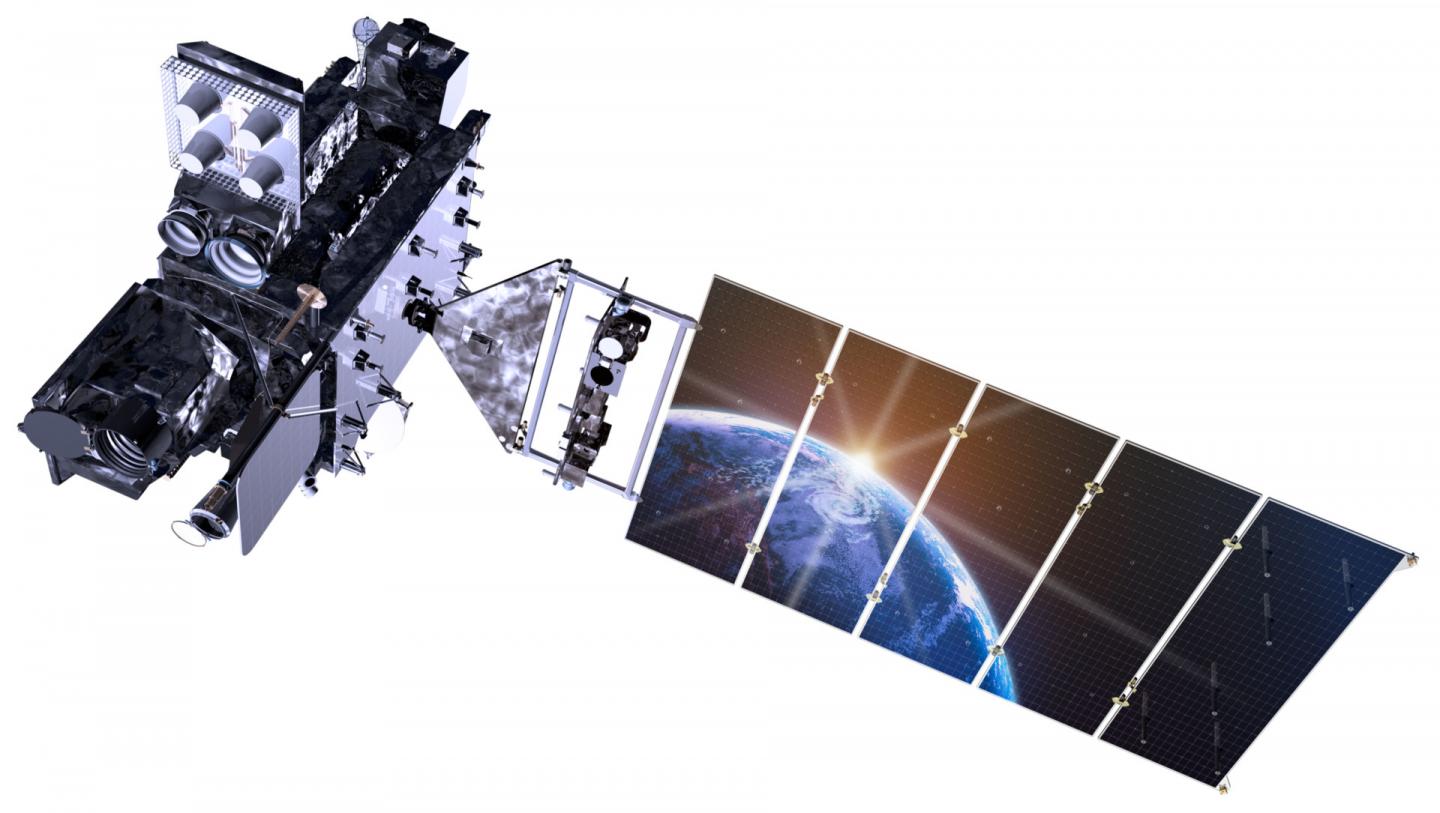
Credit: Lockheed Martin
FORT COLLINS, COLORADO – Scheduled for launch from Cape Canaveral Nov. 19, the nation's newest weather satellite, GOES-R, promises to revolutionize how researchers and forecasters see the Earth from space. Scientists at Colorado State University are at the forefront of developing new tools and products in support of the upcoming mission.
The Geostationary Operational Environmental Satellite (GOES) program, a joint venture of NASA and NOAA, constitutes the most commonly used, and arguably most important instruments for observing and forecasting weather. Currently, two GOES spacecraft are orbiting the planet from about 22,000 miles away, a carefully selected distance at which the spacecraft's orbital velocity matches the rotation of the Earth. From the perspective of a viewer on Earth, the satellite appears to hover, giving it a stationary (hence "geostationary") view of our ever-changing weather.
The next-generation GOES-R satellite will include several new science instruments for Earth observation from the geostationary orbit, including the Advanced Baseline Imager (ABI) and the Geostationary Lightning Mapper (GLM).
The current GOES series of satellites observes the Earth at five different spectral bands, called "channels," of energy – one channel covers sunlight reflection, and four channels probe different levels of thermal radiation emitted by the Earth's surface and atmosphere. The new ABI instrument on GOES-R will provide 16 channels, giving scientists far more information about the Earth and its weather. This includes, for the first time in over 50 years, a true-color picture of the planet, compared to the black-and-white imagery from the current GOES series.
Moreover, the new ABI instrument senses the Earth in much higher definition – up to four times the spatial resolution for some channels – and will collect pictures of the planet at a faster cadence than the 15-minute resolution of the old series. The ABI can also scan features of interest, such as hurricanes or thunderstorms, at 1-minute or even 30-second intervals. This high refresh rate will allow forecasters to observe storm structures that evolve too rapidly for legacy sensors to capture, but hold key information related to severe weather onset.
All of these features mean forecasters will have more accurate information to use when making time-critical forecasts of weather events year-round. This will include severe storms and squall lines in the spring and summer months, tropical cyclones in the late summer and early fall, and powerful winter weather systems.
Development of satellite-based products and forecaster-friendly tools has been at the core of research at the Cooperative Institute for Research in the Atmosphere (CIRA) at Colorado State University since its inception in 1980.
One of only 16 cooperative partnerships with NOAA nationwide, CIRA harnesses the research excellence of CSU, particularly the Department of Atmospheric Science, to bridge the gap that often exists between basic research and operation applications. CIRA's expertise in satellite remote sensing and computer modeling of the Earth's atmosphere plays an important role in advancing NOAA's operational capabilities, for the benefit of all.
As part of the nationwide GOES-R Proving Ground initiative, sponsored by NOAA, researchers at CIRA have developed several new forecast products to use the new features of GOES-R. They are in the process of deploying these products to NOAA regional centers and National Weather Service forecast offices nationwide.
CIRA research scientist Steve Miller leads a team to harness the utility of the GOES-R Advanced Baseline Imager. They have developed a suite of algorithms that will maximize the potential of the ABI data to produce ultra-high-definition, true-color images of the planet. They've done this using data from a sister geostationary satellite launched by the Japan Meteorological Agency, which carries a similar instrument to the ABI. Miller's team's work will help characterize surface features such as wildfires, snowfields, dust storms, dense fog layers, and other difficult-to-identify phenomena.
"Through its vastly improved combination of space, time, and multi-channel coverage, the ABI will give us an unprecedented ability to identify the unique 'fingerprints' of various surface and atmospheric features, allowing us to distinguish between them in what tend to be very complex scenes," Miller said. "One new capability we are all very excited about is true color imagery, which is perhaps the most visually intuitive form of satellite imagery and one that we can all relate to. It captures the wonder and beauty of our Blue Marble planet while at the same time giving forecasters a practical, at-a-glance tool for rapidly assessing the current weather situation."
The lightning mapper instrument, called the GLM, will provide better forecast capabilities for both severe storms over land and tropical weather at sea, including enhanced identification of tropical storms as they rapidly intensify into powerful systems. The recent devastation caused by Hurricane Matthew as it roared through the Caribbean before hitting the U.S. eastern seaboard demonstrates the need for the best possible information for these storms.
NOAA scientist John Knaff, one of the NOAA researchers embedded at CIRA, is developing tools to look at lightning frequency and intensity inside these storms using the GLM as a metric for storm strength. The more lightning that is occurring in these storms, the stronger the updrafts that feed the storm, and the more likely it will be that the storm strengthens.
Improving weather forecasts over the continental U.S. is another area where NOAA researchers, working hand-in hand with CSU and CIRA, are making progress. By utilizing every channel the ABI has to offer, NOAA researcher Dan Lindsey leads a team at CIRA to seamlessly blend observations from GOES-R into a graphical representation that matches exactly the visualizations created by our most sophisticated weather forecast models. Weather forecasters will then see weather as it evolves over time, with the ability to match their view with the predicted changes in weather. If the forecast model has errors in it, the transition between observations and forecasts will be much more apparent, and the forecast guidance can be adjusted appropriately.
CIRA researchers led by Bernie Connell are also putting together training programs for meteorologists nationwide to learn how best to use these products. Connell's work will help forecasters take full advantage of GOES-R capabilities starting on day one. Additionally, Andrea Schumacher of CIRA serves as a liaison between the GOES-R program and the National Hurricane Center, where she helps evaluate GOES-R products to optimize their use in improving hurricane forecasting.
"Hurricanes spend the majority of their lifetimes over the open ocean, making geostationary satellite data a crucial data source for forecasters," Schumacher said. "The improvements and enhancements provided by GOES-R are going to give forecasters an unprecedented view of the tropical oceans, which is expected to improve their ability to monitor and predict these powerful storms."
As the future of satellite technology becomes today's reality, researchers at CSU, in partnership with NOAA and NASA, will continue to lead the way in developing better and more accurate forecast products. More information about CIRA and its ongoing GOES-R research can be found at:
http://www.cira.colostate.edu
http://rammb.cira.colostate.edu/research/goes-r/proving_ground/
http://rammb.cira.colostate.edu/research/goes-r/proving_ground/blog/
###
Media Contact
Anne Manning
[email protected]
970-491-7099
@ColoStateNews
############
Story Source: Materials provided by Scienmag


