Satellite-derived bathymetry continues to advance and improve rapidly. A recent scientific study has confirmed the effectiveness of a methodology developed to obtain bathymetric data from satellite images in the Western Mediterranean. The results of this research, published in the prestigious International Journal of Applied Earth Observation and Geoinformation, reaffirm the value of this tool for monitoring coastal areas with varying turbidity levels and diverse seafloor characteristics.
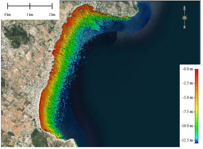
Credit: Satellite-Derived Bathymetry (SDB) from Sentinel-2 images (2020) in Son Servera Bay. The main study area, Cala Millor beach, is located in the southern part of the image / Sandra Paola Viaña-ICMAN
Satellite-derived bathymetry continues to advance and improve rapidly. A recent scientific study has confirmed the effectiveness of a methodology developed to obtain bathymetric data from satellite images in the Western Mediterranean. The results of this research, published in the prestigious International Journal of Applied Earth Observation and Geoinformation, reaffirm the value of this tool for monitoring coastal areas with varying turbidity levels and diverse seafloor characteristics.
The study was conducted in Cala Millor (Mallorca, Spain), an ecosystem of great significance due to its marine biodiversity but also its potential vulnerability to the effects of global change. The researchers successfully and accurately mapped its coastal seabed using satellite images from the Sentinel-2 twin satellites. This study represents the first attempt to test this methodology in an area with the presence of Posidonia oceanica, an endemic Mediterranean aquatic plant with significant ecological value.
This work has been carried out through a collaboration between researchers from the Institute of Marine Sciences of Andalusia (ICMAN-CSIC), the Coastal Observation System of the Balearic Islands (ICTS-SOCIB), and the National Oceanic and Atmospheric Administration (NOAA) of the United States.
“These tools are a valuable support for coastal management, as they provide up-to-date and continuous information on the morphodynamic changes occurring along the coasts. They are relevant in assisting decision-makers and defining effective adaptation measures against the impacts of global change, ultimately contributing to a more resilient coast,” explains Sandra Viaña-Borja, a researcher at the ICMAN-CSIC.
Bathymetry, decisive for Marine Strategies
Satellite-Derived Bathymetry (SDB) is moving a step closer towards consolidating itself as an alternative to traditional bathymetric techniques carried out by aircraft or ships. The main advantage that satellites offer is their open-access data and higher spatial coverage, eliminating the need for physical presence in the area or costly deployments. Nevertheless, despite the substantial advancements achieved in recent years, researchers are confronted with the primary challenge of substantiating the global and operational efficacy and precision of replicating these models in regions characterized by distinct features.
This methodology has already been employed with consistent results in other regions of the planet, such as the East Coast of the United States and the Caribbean. Now, it has been evaluated in a different ecosystem, the Mediterranean, where Cala Millor beach is one of the most monitored by the Comprehensive Beach Monitoring System of the ICTS-SOCIB, which has been operating since 2011. Moreover, due to its significance, the European Commission has recently approved a grant for the LIFE AdaptCalaMillor project, aiming to promote the adaptation of this beach to climate change and enhance the resilience of its infrastructure, ecosystems, and services.
Generating detailed maps of underwater topography is crucial to support a wide range of activities near the coast, such as dredging, environmental management, planning communication cable and pipeline routes, infrastructure maintenance, hydrographic applications, navigation, aquaculture and fisheries, research, tourism, and recreational sports. Moreover, bathymetry is one of the key features for the formulation of Marine Strategies, as outlined by the directives of the European Commission. This instrumental component establishes the overarching regulatory framework that guides and governs diverse sectoral policies and administrative measures pertaining to the marine environment.
“Currently, we are implementing these tools in other regions such as Galicia (NE Atlantic), South Korea, and Alaska, where we have obtained promising results. It is important to highlight that, according to the International Hydrographic Organization, more than half of the shallow seafloors in our oceans remain unmapped or are outdated. Satellite-derived bathymetry is a free and easily accessible technology. Undoubtedly, it is the future of coastal monitoring,” emphasizes Isabel Caballero de Frutos, a researcher at ICMAN-CSIC.
Funding
This research was supported by the grant OAPN (Observatory TIAMAT, 2715/2021), IJC2019-039382-I and project RTI2018- 098784-J-I00 both funded by MCIN/AEI/10.13039/501100011033 and by “ERDF A way of making Europe”; grant PTA2020-018491-I funded by MCIN/AEI/10.13039/501100011033 and by “ESF Investing in your future”; and by the European Union-NextGenerationEU Agreement between MITECO, CSIC, AZTI, SOCIB, and the universities of Vigo and Cadiz, to promote research and generate scientific knowledge in the field of marine sustainability. The research was also supported by the National Oceanic and Atmospheric Administration (NOAA). This work represents a contribution to CSIC’s Thematic Interdisciplinary Platforms PTI TELEDETECT and PTI OCEANS+.
Journal
International Journal of Applied Earth Observation and Geoinformation
DOI
10.1016/j.jag.2023.103328


