• HOME
  • NEWS
  • EXPLORE
    • CAREER
      • Companies
      • Jobs
    • EVENTS
    • iGEM
      • News
      • Team
    • PHOTOS
    • VIDEO
    • WIKI
  • BLOG
  • COMMUNITY
    • FACEBOOK
    • INSTAGRAM
    • TWITTER
Saturday, February 7, 2026
BIOENGINEER.ORG
No Result
View All Result
  • Login
  • HOME
  • NEWS
  • EXPLORE
    • CAREER
      • Companies
      • Jobs
        • Lecturer
        • PhD Studentship
        • Postdoc
        • Research Assistant
    • EVENTS
    • iGEM
      • News
      • Team
    • PHOTOS
    • VIDEO
    • WIKI
  • BLOG
  • COMMUNITY
    • FACEBOOK
    • INSTAGRAM
    • TWITTER
No Result
View All Result
Bioengineer.org
No Result
View All Result
Home NEWS Science News

Hurricane Oscar on satellite imagery: A one-eyed little monster with a tail

Bioengineer by Bioengineer
October 31, 2018
in Science News
Reading Time: 2 mins read
0
Share on FacebookShare on TwitterShare on LinkedinShare on RedditShare on Telegram
IMAGE

Credit: Credit: NASA/NRL

Of course, tropical cyclones have one eye and with Halloween on the horizon, false-colored infrared imagery from NASA's Aqua satellite brought out that eye in this small tropical monster with a tail of thunderstorms.

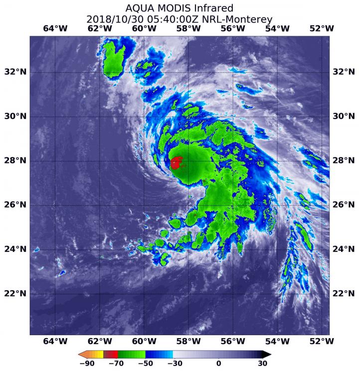
When NASA's Aqua satellite passed over the Central Atlantic Ocean, it took Hurricane Oscar's cloud top temperatures that helped forecasters key into where the strongest side of the storm was located.

Cloud top temperatures determine strength of the thunderstorms that make up a tropical cyclone. The colder the cloud top, the stronger the uplift in the storm that helps thunderstorm development. Basically, infrared data helps determine where the most powerful storms are within a tropical cyclone.

The Moderate Resolution Imaging Spectroradiometer or MODIS instrument aboard Aqua provided that infrared data on Oct. 30 at 1:40 a.m. EDT (0540 UTC) MODIS data showed cloud top temperatures in strongest storms around Oscar's eye were as cold as or colder than minus 70 degrees Fahrenheit (minus 56.6 degrees Celsius). NASA research indicates very cold cloud tops with the potential to generate very heavy rainfall.

The National Hurricane Center or NHC said " Cloud-top temperatures have warmed a bit overall, and the convective pattern is becoming more asymmetric as dry air is infiltrating the southern and eastern part of Oscar's circulation. However, the hurricane is still producing plenty of inner-core convection and some lightning strikes."

A fragmented band of thunderstorms wrapping into the center of circulation from the southeast gave the storm an appearance of having a tail.

MODIS imagery also showed that Oscar is a small storm. Hurricane-force winds extend outward up to 25 miles (35 km) from the center, and tropical-storm-force winds extend outward up to 90 miles (150 km).

At 11 a.m. EDT (1500 UTC) on Oct. 30 the center of Hurricane Oscar was located near latitude 29.7 North, longitude 57.7 West. Oscar is moving toward the north-northeast near 14 mph (22 kph). A north-northeastward or northeastward motion with an increase in forward speed is expected through Friday. Maximum sustained winds are near 100 mph (155 kph) with higher gusts. The estimated minimum central pressure is 972 millibars.

Gradual weakening is forecast during the next several days, but Oscar is expected to become a powerful extratropical low over the north-central Atlantic Ocean by late Wednesday, Oct. 31.

###

For updated forecasts, visit: http://www.nhc.noaa.gov

Media Contact

Rob Gutro
[email protected]
@NASAGoddard

http://www.nasa.gov/goddard

Original Source

https://blogs.nasa.gov/hurricanes/tag/oscar-2018/

Share12Tweet8Share2ShareShareShare2

Related Posts

Succinate Receptor 1 Limits Blood Cell Formation, Leukemia

February 7, 2026

Palmitoylation of Tfr1 Drives Platelet Ferroptosis and Exacerbates Liver Damage in Heat Stroke

February 7, 2026

Oxygen-Enhanced Dual-Section Microneedle Patch Improves Drug Delivery and Boosts Photodynamic and Anti-Inflammatory Treatment for Psoriasis

February 7, 2026

Scientists Identify SARS-CoV-2 PLpro and RIPK1 Inhibitors Showing Potent Synergistic Antiviral Effects in Mouse COVID-19 Model

February 7, 2026
Please login to join discussion

POPULAR NEWS

  • Robotic Ureteral Reconstruction: A Novel Approach

    Robotic Ureteral Reconstruction: A Novel Approach

    82 shares
    Share 33 Tweet 21
  • Digital Privacy: Health Data Control in Incarceration

    63 shares
    Share 25 Tweet 16
  • Study Reveals Lipid Accumulation in ME/CFS Cells

    57 shares
    Share 23 Tweet 14
  • Breakthrough in RNA Research Accelerates Medical Innovations Timeline

    53 shares
    Share 21 Tweet 13

About

We bring you the latest biotechnology news from best research centers and universities around the world. Check our website.

Follow us

Recent News

Succinate Receptor 1 Limits Blood Cell Formation, Leukemia

Palmitoylation of Tfr1 Drives Platelet Ferroptosis and Exacerbates Liver Damage in Heat Stroke

Oxygen-Enhanced Dual-Section Microneedle Patch Improves Drug Delivery and Boosts Photodynamic and Anti-Inflammatory Treatment for Psoriasis

Subscribe to Blog via Email

Enter your email address to subscribe to this blog and receive notifications of new posts by email.

Join 73 other subscribers
  • Contact Us

Bioengineer.org © Copyright 2023 All Rights Reserved.

Welcome Back!

Login to your account below

Forgotten Password?

Retrieve your password

Please enter your username or email address to reset your password.

Log In
No Result
View All Result
  • Homepages
    • Home Page 1
    • Home Page 2
  • News
  • National
  • Business
  • Health
  • Lifestyle
  • Science

Bioengineer.org © Copyright 2023 All Rights Reserved.